
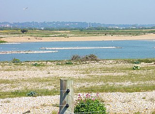
Pagham Harbour is a 629-hectare (1,550-acre) biological and geological Site of Special Scientific Interest on the western outskirts of Bognor Regis in West Sussex. It is a Geological Conservation Review site, a Nature Conservation Review site, a Ramsar site, a Special Protection Area and a Marine Conservation Zone. An area of 599.1 hectares is a Local Nature Reserve.

Hastings Country Park was formed in 1974 and covers 345 hectares east of Hastings in England. Sandstone cliffs, glens covered with gorse and trees, footpaths, nature trails, picnic areas and ample car parking are some of the features at the country park. Set in the High Weald Area of Outstanding Natural Beauty, it is also a Local Nature Reserve as Hastings Country Park & Fairlight Place Farm. An area of 184.5 hectares has been designated Hastings Cliffs Special Area of Conservation. Most of the park is in Hastings Cliffs to Pett Beach Site of Special Scientific Interest and it is also part of Hastings Cliffs Special Area of Conservation and Dungeness, Romney Marsh and Rye Bay Special Protection Area. Two areas in the park are Geological Conservation Review sites.

Asham Quarry is a 2.6-hectare (6.4-acre) geological Site of Special Scientific Interest north of Newhaven in East Sussex. It is a Geological Conservation Review site and in the Sussex Downs Area of Outstanding Natural Beauty.

Brighton to Newhaven Cliffs is a 165.4-hectare (409-acre) biological and geological Site of Special Scientific Interest and Geological Conservation Review site, which stretches along the coast between Brighton and Newhaven in East Sussex. An area of 16.4 hectares is the Castle Hill, Newhaven Local Nature Reserve

Castle Hill is a 114.6-hectare (283-acre) biological Site of Special Scientific Interest on the eastern outskirts of Brighton in East Sussex. It is a Special Area of Conservation and Nature Conservation Review site. The northern half is a national nature reserve
Dungeness, Romney Marsh and Rye Bay is a 10,172.9-hectare (25,138-acre) biological and geological Site of Special Scientific Interest which stretches from New Romney in Kent to Winchelsea in East Sussex. An area of 5,129.5 hectares is a Special Protection Area, an area of 3,141.1 hectares is a Special Area of Conservation, and an area of 6,377.6 hectares is a Ramsar Site, a wetland site designated of international importance under the Ramsar Convention. Part of the site is in the High Weald Area of Outstanding Natural Beauty, parts are Geological Conservation Review sites, part is a Local Nature Reserve, and part is a Royal Society for the Protection of Birds nature reserve, and part is a National Nature Reserve.

Seaford to Beachy Head is a 1,108.7-hectare (2,740-acre) biological and geological Site of Special Scientific Interest which stretches from Seaford to Eastbourne in East Sussex. It has several Geological Conservation Review sites. Part of it is a Nature Conservation Review site, Grade I. An area of 150 hectares is a Local Nature Reserve managed by the Sussex Wildlife Trust.

Folkestone Warren is a 316.3-hectare (782-acre) biological and geological Site of Special Scientific Interest (SSSI) which runs along the coast between Folkestone and Dover in Kent. It is a Nature Conservation Review site and it contains three Geological Conservation Review sites and part of a fourth. An area of 83.6 hectares is a Local Nature Reserve,

Morston Cliff is a 1-hectare (2.5-acre) geological Site of Special Scientific Interest east of Wells-next-the-Sea in Norfolk. It is a Geological Conservation Review site. It is part of Blakeney National Nature Reserve, which is managed by the National Trust, and of the Norfolk Coast Area of Outstanding Natural Beauty.

Benfield Hill is an 11.8-hectare (29-acre) Local Nature Reserve (LNR) on the northern outskirts of Hove in East Sussex and is within the boundaries of the South Downs National Park. It is owned and managed by Brighton and Hove City Council.

Hurst Castle and Lymington River Estuary is a 1,077.3-hectare (2,662-acre) biological and geological Site of Special Scientific Interest near Lymington in Hampshire. It is a Nature Conservation Review site and two areas are Geological Conservation Review sites. Three areas are local nature reserves, Boldre Foreshore, Sturt Pond and Lymington and Keyhaven Marshes; the latter site is managed by the Hampshire and Isle of Wight Wildlife Trust. Part of it is North Solent National Nature Reserve. It is part of Solent and Southampton Water Ramsar site and Special Protection Area. Parts of it are in Solent Maritime and Solent and Isle of Wight Lagoons Special Areas of Conservation.

North Solent is a 1,186.7-hectare (2,932-acre) biological and geological Site of Special Scientific Interest along the north bank of the Solent between East End and Calshot in Hampshire. It is a Nature Conservation Review site, Grade I. Part of it is in North Solent National Nature Reserve and two areas are Geological Conservation Review sites. It is part of Solent and Southampton Water Ramsar site and Special Protection Area, and of Solent Maritime Special Area of Conservation. Boldre Foreshore is a local nature reserve.

Lymington and Keyhaven Marshes is a 738-hectare (1,820-acre) nature reserve which stretches from Keyhaven along the south coast across the Lymington River in Hampshire. It is managed by the Hampshire and Isle of Wight Wildlife Trust. It is part of Solent and Southampton Water Ramsar site and Special Protection Area. Some areas are part of two Special Areas of Conservation, Solent and Isle of Wight Lagoons and Solent Maritime and Solent. It is also part of Hurst Castle and Lymington River Estuary, which is a Site of Special Scientific Interest, and of North Solent Marshes Nature Conservation Review site, Grade 2. Two areas are Geological Conservation Review sites, and two are Local Nature Reserves, Boldre Foreshore and Lymington-Keyhaven Marshes.

