
Szczecin is the capital and largest city of the West Pomeranian Voivodeship in northwestern Poland. Located near the Baltic Sea and the German border, it is a major seaport and Poland's seventh-largest city. As of December 2021, the population was 395,513.

Toruń is a city on the Vistula River in north-central Poland and a UNESCO World Heritage Site. Its population was 196,935 as of December 2021. Previously, it was the capital of the Toruń Voivodeship (1975–1998) and the Pomeranian Voivodeship (1921–1945). Since 1999, Toruń has been a seat of the local government of the Kuyavian-Pomeranian Voivodeship and is one of its two capitals, together with Bydgoszcz. The cities and neighboring counties form the Bydgoszcz–Toruń twin city metropolitan area.

The West Pomeranian Voivodeship, also known as the West Pomerania Province, is a voivodeship (province) in northwestern Poland. Its capital and largest city is Szczecin. Its area equals 22 892.48 km2, and in 2021, it was inhabited by 1,682,003 people.

Świnoujście is a city in Western Pomerania and seaport on the Baltic Sea and Szczecin Lagoon, located in the extreme north-west of Poland. Situated mainly on the islands of Usedom and Wolin, it also occupies smaller islands. The largest is Karsibór island, once part of Usedom, now separated by the Piast Canal dug in the late 19th century to facilitate ship access to Szczecin.

Police is a town in the West Pomeranian Voivodeship, in northwestern Poland. It is the capital of Police County and one of the biggest towns of the Szczecin agglomeration.

Controlled-access highways in Poland are part of the national roads network and they are divided into motorways and expressways. Both types of highways feature grade-separated interchanges with all other roads, emergency lanes, feeder lanes, wildlife crossings and dedicated roadside rest areas. Motorways differ from expressways in their technical parameters like designated speed, permitted road curvature, lane widths or minimal distances between interchanges. Moreover, expressways might have single-carriageway sections in case of low traffic densities.

The Monash Freeway is a major urban freeway in Victoria, Australia, linking Melbourne's CBD to its south-eastern suburbs and beyond to the Gippsland region. It carries up to 180,000 vehicles per day and is one of Australia's busiest freeways. The entire stretch of the Monash Freeway bears the designation M1.
King's Highway 402, commonly referred to as Highway 402 and historically as the Blue Water Bridge Approach, is a 400-series highway in the Canadian province of Ontario that connects the Blue Water Bridge international crossing near Sarnia to Highway 401 in London. It is one of multiple trade links between Ontario and the Midwestern United States. It is four lanes for much of its length, though the approach to the Blue Water Bridge is six lanes.

Route 4, also known as the Colonel Rodman Highway, is a 10.37-mile-long (16.69 km) numbered state highway located in Washington County and southern Kent County, Rhode Island, United States. The route is a major north–south freeway in the southern Providence metropolitan area, directly linking Providence with eastern Washington County, the beaches of Narragansett and South Kingstown, and the city of Newport. Route 4 begins as a two-lane divided highway at an intersection with U.S. Route 1 in the town of North Kingstown, becoming a limited-access freeway after 1.89 miles (3.04 km). The route has four numbered interchanges before terminating in the city of Warwick, where the northbound lanes merge into Interstate 95 (I-95).

Solidarity Szczecin–Goleniów Airport is the main domestic and international airport serving the city of Szczecin in Poland and is located 45 km (28 mi) northeast of the city, near the town of Goleniów, in the village of Glewice. About 1.6 million residents live within its catchment area.
The Gateway Motorway is a major tolled motorway in Brisbane, Queensland, Australia which includes the Sir Leo Hielscher Bridges. The motorway is operated by toll road operator Transurban.

The autostrada A6 in Poland is a short motorway that starts at the Polish/German border at Kołbaskowo/Pomellen connecting to the German A11 autobahn. It forms a southern bypass of the Szczecin metropolitan area and terminates at Rzęśnica interchange to the east of the city, from where it continues in an expressway standard as S3 towards Świnoujście and S6 towards Gdańsk. Its length is 29.2 km (18.1 mi). The motorway is part of the European route E28.
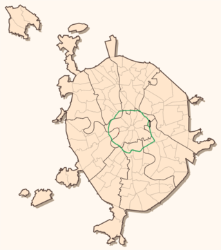
The Third Ring Road, or The Third Ring, is a beltway around central Moscow, Russia, located between the Garden Ring in the city centre and the Moscow Ring Road (MKAD).
Ueckermünde is a seaport town in northeast Germany, located in the district of Vorpommern-Greifswald, Western Pomerania, near Germany's border with Poland's Police County.

Interstate 10 (I-10) runs for 362 miles (583 km) in Florida as the easternmost section of an east–west Interstate Highway in the southern United States. It is also the eastern end of one of three coast-to-coast Interstates, along with I-80 and I-90. The highway runs east from the Alabama border, traveling through the Panhandle of Florida, serving the major cities of Pensacola, Tallahassee, Lake City, ending at Jacksonville, and carries the hidden Florida Department of Transportation (FDOT) designation of State Road 8 (SR 8).

Memorial Parkway, also known as the Parkway, is a major thoroughfare in Huntsville, Alabama that carries over 100,000 vehicles on average a day. It, in whole or in part, follows U.S. Route 231, U.S. Route 431, U.S. Route 72, and State Route 53 through the Huntsville city limits. It is a limited access road through most of Huntsville city proper, providing exits to the frontage road which allows access to road intersections, as well as businesses and residences along the route. Both the limited access and frontage roads are referred to as Memorial Parkway. Originally constructed to bypass downtown Huntsville and officially opened on December 1, 1955, the highway is the major commercial thoroughfare through Huntsville, a status it has held since the mid-1960s.

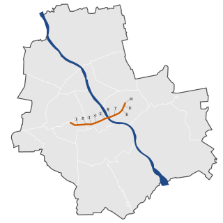
The Tricity Ring Road is a ring road in Poland bypassing the metropolitan area formed by the cities of Gdynia, Sopot and Gdańsk commonly known as the Tricity. The beltway runs north to south from Gdynia to Pruszcz Gdański and is 38.6 km (24.0 mi) long. It forms a part of the S6 expressway which will eventually run from Szczecin to Gdańsk. It is also part of the European route E28.

The Świętokrzyski Bridge is a bridge over the Vistula river in Warsaw, Poland linking Powiśle neighborhood with Praga Północ district.

Berlinka is the informal Polish and Russian name given to sections of the unfinished Reichsautobahn Berlin-Königsberg, which was a pre-World War II German Reichsautobahn project to connect Berlin with Königsberg in East Prussia. In the late 1930s, the sections near these two cities were finished, but not the larger section in between. The German demand in 1939 to run this road across the Polish Corridor with extraterritorial status and Poland's refusal to allow this was an important element in the tensions that led to the start of World War II. After the war, the German Democratic Republic, the People's Republic of Poland and the Soviet Union's Kaliningrad Oblast inherited the remnants.
Baths Route is a road in Warsaw, Poland. It connects the center of Warsaw with the east-bank of Warsaw. It was built from 1971 to 1974.

