Castlegate (York)

Last updated

Castlegate
Castlegate, York showing the spire of St Mary's Church - geograph.org.uk - 886305.jpg
View south-west along Castlegate
Castlegate (York)
Location within York
Location York, United Kingdom
Coordinates 53°57′25″N1°04′50″W / 53.9570°N 1.0806°W / 53.9570; -1.0806 Coordinates: 53°57′25″N1°04′50″W / 53.9570°N 1.0806°W / 53.9570; -1.0806
North west end
Major
junctions
Friargate
South east end Tower Street

Castlegate is a historic street in York, England, which leads to York Castle. [1]

Contents

History

The street roughly follows the line of Roman road, which ran between the fortress of Eboracum and the River Ouse, and remains of residential Roman buildings have been found in excavations. A hoard from the Viking Jorvik period has also been found, while St Mary's Church, on the street's north-east side, appears to have pre-Conquest origins. [2] [3]

In the Mediaeval period, it linked the city of York with the bailey of York Castle, although no references to it are known from before the 14th-century. In this period, its north-east side was dominated by St Mary's, and its south-west side by the York Franciscan Friary. [3]

In the Georgian period, the street was a desirable location to live, and the mansions of Fairfax House and Castlegate House were erected. Castlegate was shortened slightly in 1826, when the castle's prison was extended, and the street lost importance after 1881, when Clifford Street was constructed to its west, providing a more direct route out of the city. [2] [3]

From 1913 until 1954, the headquarters of the Yorkshire Gazette were on Castlegate, while in 1921, the St George's Hall cinema opened, closing in 1959. [2] The street currently hosts a mixture of commercial and residential uses, including a small chocolate factory, and was pedestrianised in 2020. [4] [5]

Layout and architecture

The street runs south-east, from the junction of Clifford Street, Coppergate, King Street and Nessgate; to its junction with Tower Street, at the Castle Car Park. Friargate leads off its south-west side, while there is access to the Coppergate Shopping Centre from its north-east side. [3]

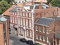
Notable buildings on the north-east side include 1-5 Castlegate, built about 1730 and including the Blue Boar pub; 7 Castlegate, which is mid-18th century; 9-11 Castlegate, built in 1766; St Mary's Church; Fairfax House; and large 19th-century houses at 29 and 31 Castlegate. On the south-west side lie 12-16 Castlegate, built about 1730; 18 Castlegate, also early 18th-century; 22 Castlegate, built in the late-18th century but including part of the wall of the Franciscan Friary; and Castlegate House. [3]

Related Research Articles

<span class="mw-page-title-main">Scandinavian York</span> Historical Norse colony in present-day England

Scandinavian York, Viking Yorkshire or Norwegian York is a term used by historians for the south of Northumbria during the period of the late 9th century and first half of the 10th century, when it was dominated by Norse warrior-kings; in particular, it is used to refer to York, the city controlled by these kings.

<span class="mw-page-title-main">York Castle</span> Grade I listed monument in York, England

York Castle is a fortified complex in the city of York, England. It consists of a sequence of castles, prisons, law courts and other buildings, which were built over the last nine centuries on the south side of the River Foss. The now-ruined keep of the medieval Norman castle is commonly referred to as Clifford's Tower. Built originally on the orders of William I to dominate the former Viking city of Jórvík, the castle suffered a tumultuous early history before developing into a major fortification with extensive water defences. After a major explosion in 1684 rendered the remaining military defences uninhabitable, York Castle continued to be used as a gaol and prison until 1929.

<span class="mw-page-title-main">Bootham</span> Street and area of York, England

Bootham is a street in the city of York, in England, leading north out of the city centre. It is also the name of the small district surrounding the street.

<span class="mw-page-title-main">Fishergate</span> Street in York, England

Fishergate is a street and surrounding area of York, England.

<span class="mw-page-title-main">History of York</span> History of the city of York, England

The history of York, England, as a city dates to the beginning of the first millennium AD but archaeological evidence for the presence of people in the region of York dates back much further to between 8000 and 7000 BC. As York was a town in Roman times, its Celtic name is recorded in Roman sources ; after 400, Angles took over the area and adapted the name by folk etymology to Old English Eoforwīc or Eoforīc, which means "wild-boar town" or "rich in wild-boar". The Vikings, who took over the area later, in turn adapted the name by folk etymology to Norse Jórvík meaning "wild-boar bay", 'jór' being a contraction of the Old Norse word for wild boar, 'jǫfurr'. The modern Welsh name is Efrog.

<span class="mw-page-title-main">Coppergate Shopping Centre</span> Shopping centre in the City of York, North Yorkshire, England

Coppergate Shopping Centre is a shopping centre in York in North Yorkshire, England. It is named after Coppergate, one of York's medieval streets.

<span class="mw-page-title-main">Fairfax House</span> Grade I listed building in York, England

Fairfax House is a Georgian townhouse located at No. 27, Castlegate, York, England, near Clifford's Tower and York Castle Museum. It was probably built in the early 1740s for a local merchant and in 1759 it was purchased by Charles Gregory Fairfax, 9th Viscount Fairfax of Emley, who arranged for the interior to be remodelled by John Carr (architect). After the Viscount's death in 1772, the house was sold and subsequently passed through a number of local families before spending some time as a Gentleman's Club, a Building Society and a cinema. The property was bought by York Civic Trust in the 1980s and completely restored to its former grandeur. Fairfax House is now a museum open to the public and a Grade I listed building.

<span class="mw-page-title-main">Timeline of York</span>

The following is a timeline of the history of the city of York, North Yorkshire in northern England.

<span class="mw-page-title-main">Bishophill</span> Area of the City of York, North Yorkshire, England

Bishophill is an area of central York, in England. It lies within the city walls and has been occupied since at least the Roman period.

<span class="mw-page-title-main">Coppergate</span> Street in York, England

Coppergate is a street in the city centre of York, in England. The street runs north-east from the junction of Castlegate, Nessgate, King Street and Clifford Street, to end at the junction of Pavement, Piccadilly, Parliament Street and High Ousegate.

<span class="mw-page-title-main">Pavement (York)</span> Street in York, England

Pavement is a street in the city centre of York, in England.

<span class="mw-page-title-main">Fossgate</span> Street in York, England

Fossgate is a street in the city centre of York, in England.

<span class="mw-page-title-main">Walmgate</span> Street in York, England

Walmgate is a street in the city centre of York, in England. During the Medieval period, the street was the site of a seafissh and cattle market. Walmgate Bar, was involved in the Siege of York in 1644, during the First English Civil War. During the 20th century, many of the older buildings were cleared away and newer structures put up.

<span class="mw-page-title-main">Goodramgate</span> Street in York, England

Goodramgate is a street in the city centre of York, in England.

<span class="mw-page-title-main">Ousegate</span> Street in York, England

Ousegate is a street in the city centre of York, in England. It is divided into High Ousegate and Low Ousegate.

<span class="mw-page-title-main">Clifford Street (York)</span> Street in York, England

Clifford Street is a road in the city centre of York, in England.

<span class="mw-page-title-main">Gillygate</span> Street in York, England

Gillygate is a street in York, in England, immediately north of the city centre.

<span class="mw-page-title-main">Tower Street (York)</span> Street in York, England

Tower Street is a road in the city centre of York, in England.

<span class="mw-page-title-main">Davy Tower</span>

The Davy Tower is a feature of the York city walls in England.

References

  1. "Castlegate, York". Jorvik.co.uk. Jorvik. 30 January 2013. Retrieved 18 March 2020.
  2. 1 2 3 A History of the County of York: the City of York. London: Victoria County History. 1961. Retrieved 7 August 2020.
  3. 1 2 3 4 5 An Inventory of the Historical Monuments in City of York, Volume 5, Central. London: HMSO. 1981. Retrieved 7 August 2020.
  4. Knowlson, Laura (29 March 2018). "New chocolate factory opens in York city centre". The Press. Retrieved 21 September 2020.
  5. "Castlegate to be closed to cars". The Press. 30 June 2020. Retrieved 21 September 2020.