
The Verde River is a major tributary of the Salt River in the U.S. state of Arizona. It is about 170 miles (270 km) long and carries a mean flow of 602 cubic feet per second (17.0 m3/s) at its mouth. It is one of the largest perennial streams in Arizona.

The Nisqually River is a river in west central Washington in the United States, approximately 81 miles (130 km) long. It drains part of the Cascade Range southeast of Tacoma, including the southern slope of Mount Rainier, and empties into the southern end of Puget Sound. Its outlet was designated in 1971 as the Nisqually Delta National Natural Landmark.

The Ocmulgee River is a western tributary of the Altamaha River, approximately 255 mi (410 km) long, in the U.S. state of Georgia. It is the westernmost major tributary of the Altamaha. It was formerly known by its Hitchiti name of Ocheese Creek, from which the Creek (Muscogee) people derived their name.

Oak Orchard Creek is a tributary of Lake Ontario in Orleans County, New York in the United States.

Attwater Prairie Chicken National Wildlife Refuge is a federally protected refugium encompassing one of the largest remnants of coastal prairie habitat remaining in southeast Texas, United States, and home to one of the last populations of critically endangered Attwater's prairie chickens, a ground-dwelling grouse of the coastal prairie ecosystem.
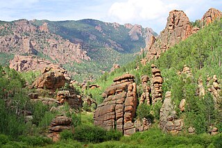
The Lost Creek Wilderness is a 119,790-acre (485 km2) wilderness area located in central Colorado in Jefferson and Park counties south of the town of Bailey. The area is situated entirely within the boundaries of the Pike National Forest.
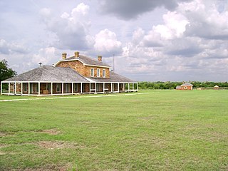
Fort Richardson was a United States Army installation located in present-day Jacksboro, Texas. Named in honor of Union General Israel B. Richardson, who died in the Battle of Antietam during the American Civil War, it was active from 1867 to 1878. Today, the site, with a few surviving buildings, is called Fort Richardson State Park, Historic Site and Lost Creek Reservoir State Trailway. It was designated a National Historic Landmark in 1963 for its role in securing the state's northern frontier in the post-Civil War era.

The Au Sable State Forest is a state forest in the north-central Lower Peninsula of Michigan. It is operated by the Michigan Department of Natural Resources.
Keeley Creek Natural Area is a Research Natural Area and a National Natural Landmark that is protected by the United States Department of Agriculture, specifically through the branch of the Forest Service. It is located in Stony River Township, in Lake County, Minnesota, and is part of the Superior National Forest.

Caledon State Park is a 2,579-acre (10.44 km2) state park located in King George, Virginia. As of 2010, the yearly visitation was 49,328. The property was initially owned by the Alexander brothers, founders of the city of Alexandria, and was established in 1659 as Caledon Plantation. Ownership passed, in 1974, to the Commonwealth of Virginia.

Sand Creek is a stream noted for the "most spectacular examples of cross-bedded sandstone and topple blocks in North America". Sand Creek flows from the Laramie Mountains in Larimer County, Colorado into Albany County, Wyoming where it joins the Laramie River.

Buffalo Lake National Wildlife Refuge is a protected area in Randall County in the Texas Panhandle. Its shortgrass prairies spill into marshes, woodlands, riparian habitat, croplands, and water-carved canyon walls that together form 7,664 acres (31.02 km2) of homes for migratory and year-round wildlife. The area forms a habitat for black-tailed prairie dogs and burrowing owls, among many other species. Some 175 acres (0.71 km2) of the refuge carries the designation of National Natural Landmark.

The South Fork Eel River Wilderness is a 12,868-acre (5,207 ha) wilderness area located in Mendocino County, California. The wilderness was added to the National Wilderness Preservation System when the United States Congress passed the Northern California Coastal Wild Heritage Wilderness Act in 2006. The Department of the Interior's Bureau of Land Management (BLM) is the agency in charge.
Devil's Sinkhole State Natural Area is a natural bat habitat near the city of Rocksprings in Edwards County in the U.S. state of Texas. Carved by water erosion, the cavern is home to several million Mexican free-tailed bats that emerge at sunset during April through October.

Mosquito Creek Lake is a reservoir in Trumbull County, northeast Ohio, in the United States. It is approximately 6 miles (9.7 km) northeast of Warren. The lake is fed by Mosquito Creek and Walnut Creek. Construction was completed in 1944.

