Description
The Cattai National Park is located on the site of the First Fleet land grant given to surgeon, Dr Thomas Arndell (1753-1821) in around 1804 and presently covers an area of 424 hectares (1,050 acres) and comprises three separate park areas: [1]
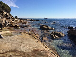
- Cattai Park at the junctions of Cattai Creek and the Hawkesbury Rivers is the largest of the three park areas and covers an area of 224 hectares (550 acres). The park has limited low impact camping grounds, barbecue areas, shelter sheds and open picnic areas along the banks of the Hawkesbury River. This area of the national park also contains The Cattai Farm area that was originally owned by Dr Thomas Arndell and the historic homestead Caddie that he began building shortly before his death in 1821. [14] [1]
- Mitchell Park is located approximately 2.5 kilometres (1.6 mi) up stream from Cattai Park and covers 140 hectares (350 acres) and includes picnic and barbecue areas. Also available within the park are approximately 4 kilometres (2.5 mi) of walking tracks that were developed by the University of Western Sydney, Hawkesbury campus, and the NSW National Parks and Wildlife Services. [14] [1]
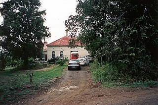
- Hope Farm is the only area within the Cattai National Park not open to the public for recreational activities at present. The park covers an area of 60 hectares (150 acres) and is located on the northern side of Cattai Park. Hope Farm is the site of a derelict stone windmill, considered to be the first European built industrial building in Australia. [14] [1]
The Cattai Estate is home to a diverse range of plants and forms a natural habitat for many native and introduced animals. Thirteen plants within the park have been recognised as unique to the area and at least one plant has been listed for conservation due to its national importance. Cattai Park and Hope Farm contain a range of native trees including Ironbarks (Eucalyptus paniculata), grey gums (E. punctata) and forest red gum (E. tereticornis) indicative of the original species found in the area. This area of the national park also contains small areas of rare virgin bushland. (NPWS, 1997, Section 4.1.2.). Parts of Cattai and Mitchell Park also contain areas of wetlands that are home to large numbers of aquatic plants and birds that are unique to the Western Sydney ecosystem. Some remaining areas of the original Cumberland Plains have also been found within the national park and are home to rare vegetation that has been lost in other areas of Western Sydney due to agriculture and urban expansion that has occurred through the centuries since European settlement. Evidence of habitation of the original occupants of the area, the Darug can also be found throughout the park and twenty-seven sites of significance have been noted. [15] [1]
- Cattai Park industrial sites
The Cattai Farm area features some significant industrial sites including historic grain silos and the ruins of a windmill believed to be the oldest industrial building surviving in NSW. [16] [1]
- Cattai Park Arndell homestead precinct garden
The garden area surrounding the Arndell homestead has a cottage type garden with a remnant area of orchard/vegetable garden to the south with some fruit trees (peaches, plums). Trees around the house include jacaranda (J.mimosaefolia), kurrajong (Brachychiton populneum), Brazilian peppercorn tree (Schinus molle var.areira), crepe myrtle (Lagerstroemia indica), mulberry (Morus sp.), Queensland nut (Macadamia integrifolia), long-leaved privet (Ligustrum ovalifolium) and African olive (Olea europaea var.cuspidata)(both possibly from former hedges) and frangipani (Plumeria rubra cv.). Shrubs include oleander (Nerium oleander), Cape plumbago (P.capensis), Syrian & Chinese hibiscus (H.syriacus cv. & H.rosa-sinensis cv.), geraniums (Pelargonium spp./cv.s), heavenly bamboo (Nandina domestica and its dwarf form, N.d.'Pygmaea'), Paris daisy (Euryops pectinatus), azaleas (Rhododendron indicum cv.s), Wisteria (W.sinensis), cotoneaster (C.sp. e.g. C.pannosus), Lady Bank's rose (Rosa banksiae cv.), Himalayan jasmine (Jasminium mesnyi), roses (Rosa cv.s) and ladder ferns (Blechnum sp.) and bulbs. [1]
- Cattai Park former orchard area (now picnic grounds area)
The floodplain below the Arndell homestead has today grass cover with scattered native and exotic tree species, predominantly river oaks (Casuarina cunninghamiana), honey locusts (Gleditsia triacanthos), Lombardy poplars (Populus nigra "Italica", black poplars (P.nigra), kurrajongs (Brachychiton populneum) and white cedars (Melia azederach var. australasica). [17] [1]
Heritage listing
As at 4 May 2017, the Cattai National Park was a place of complexity and diversity that reflects the evolution of occupation, ownership and land management from Aboriginal occupation, through the contact and subsequent conflicts with European settlement of the earliest years of the nineteenth century to the late twentieth century recreational, environmental and educational values placed on this landscape. This comprehensive cultural landscape illustrates exploitation, manipulation and appreciation of the landscape and its various resources from the necessities of subsistence to today's management for, and orientation to cultural and natural values. [18] [1]
Hope Farm collectively with Caddie is of state significance as a representative of continuous settlement and farming activities by one family since the (European) settlement of the colony and the allocation of land grants along the Hawkesbury River in the early 1800s. [1]
Hope Farm has state significance for its associations between European settlers and the historic Aboriginal tribe, the Dharug, who were the original inhabitants of the area. It also has state significance for its associations with Dr Thomas Arndell, a surgeon, magistrate and land holder, who formed part of the first medical staff that cared for convicts of the First Fleet. [1]
The Hope Farm house complex is of local significance as it remains a key focal element of the early pastoral landscape of Hope Farm that exhibits characteristics typical to Cumberland Plain colonial landscapes and setting, which are becoming increasingly rare in the Sydney Region due to the pressure of modern urban development. The farm buildings themselves are amongst a declining number of rural groups surviving in the area. The surviving rural landscape has local significance due to its ability to demonstrate important aspects of early European occupation such as buildings, cultural plantings, early approach routes, fencing and some archaeological features and sites. [1]
The Hope Farm homestead has aesthetic significance at a local level as a simple slab hut (with later alterations and additions), being an integral part of a larger cultural landscape that includes adjoining Cattai and Mitchell Parks. The homestead complex also retains some cultural plantings including the English oaks (Quercus robur) and crepe myrtles (Lagerstroemia indica) that add to the aesthetic quality of the landscape. The homestead also has aesthetic significance at a local level for its siting and high scenic quality being located along the Hawkesbury River. Windmill Tower before c. – c. 1809. [19] [1]
Cattai Estate was listed on the New South Wales State Heritage Register on 2 April 1999 having satisfied the following criteria. [1]
The place is important in demonstrating the course, or pattern, of cultural or natural history in New South Wales.
Cattai and Mitchell Parks are of national cultural significance. Collectively they encompass a most substantial portion of an original First Fleet grant and an early Common that in the case of the former has been retained generally intact and which has evolved over two hundred years according to an array of external factors, personal tastes, needs and preferences. This complex cultural landscape reflects the broader regional patterns of the Hawkesbury as well as the individual specific aspirations and regional patterns of the Hawkesbury as well as he individual specific aspirations and achievements of one family. It documents an extensive variety of European activities achievements of one family. It documents an extensive variety of European activities (domestic, industrial, agricultural, pastoral, recreational and aesthetic refinements) and illustrates their evolution according to the several historic catalysts. With the extensive evidence of Aboriginal occupation also contained in the parks, including evocative evidence of the contact period, it is possible to illustrate and investigate many hundreds and possibly thousands of years of continuous occupation and cultural diversity. [1]
The physical demonstration of these several "layers" of occupation is spread throughout the entire park and takes many forms, architectural features, relics, archaeological sites, changes, additions to or subtractions from the landscape. These "constructs" of culture are not the only evidence the environment. Areas of little or no change have been left for perceived or exploited the environment. Areas of little or no change have e been left for particular reasons which are as instructive of purpose and action as are the demonstrable changes and additions. [1]
Most sites, places are relics display a high degree of integrity. They provide landmarks that identify the landscape as "old". Often they have a picturesque and evocative quality that reflects a nineteenth century appreciation of the landscape as well as appealing of twentieth century sensibilities. Individually the sites could be used to scientifically investigate or document various aspects of technological and/or cultural practices. The well defined history of the park makes such investigation particularly could be exploited and interpreted. This is true for both site specific questions and more general issues of history, culture and technology. [1]
Important or valuable as individual sites are, however, the most significant value of Cattai and Mitchell Parks are in their collective diverse and well preserve tapestry of Aboriginal and European lives and endeavours. [1]
The place is important in demonstrating aesthetic characteristics and/or a high degree of creative or technical achievement in New South Wales.
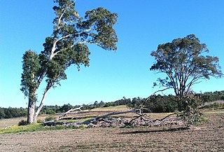
The natural systems of Cattai National Park are important as they include representative natural ecosystems of the Hawkesbury River floodplain and adjacent foothills on Hawkesbury sandstone and a range of rare elements which are significant at the regional, state and national level. While the vegetation communities of Cattai National Park are not Cumberland Plain Woodland, their location within this geographic area increases their significance because of the extent of clearing that has occurred on the Cumberland Plain generally. [1]
The underlying geology and soils provide a representative demonstration of the interaction between older, eroded sandstone foothills and the more recent alluvial deposits. the Burralow Swamp soil landscape found at Reedy Swamp in Mitchell Park is of restricted distribution in the region. [1]
Two plant communities, Sedgeland dominated by Knotweed and Paperbark Low Open-forest, are of significance as they are considered vulnerable to extinction in New South Wales. Several plant communities are of regional significance as they are of urbane expansion. These communities include Dry Rainforest, Forest Red gum Open-forest, and River Oak Open-forest. The Mitchell Park section includes an unusually diverse range of paint communities within a relatively small area. [1]
Cattai National Park provides suitable habitat for one plant species of national conservation significance, Brasenia schreberi, and one plant species of regional significance, Whalebone Tree (Streblus brunonianus). The Park also provides habitat for a large number of plant species which are considered vulnerable in western Sydney. [1]
The Park includes a diverse range of fauna habitats, including wetland habitats which are of restricted distribution in the region, and provides suitable habitat for many fauna species listed in Schedule 12 of the National Parks and Wildlife Act. [1]
The Park also demonstrates the relationship between the underlying natural characteristics, stages of agricultural development in the area and subsequent regeneration following cessation of agricultural pursuits. [1]
The place has a strong or special association with a particular community or cultural group in New South Wales for social, cultural or spiritual reasons.
Cattai National Park in its short history as a public recreation reserve has gained social value as an important recreational facility for the west and northwest of Sydney. It provides for many visitors throughout the year who are attracted to the Park by the sense of space and the connections that the park provides to the cultural and natural landscape. [1]
The park has particular value for families providing as it offers a diverse and attractive range of cross generational interests that encompass historic, recreational, educational and environmental interests. This multi-dimensional aspect of the Park would appear to attract a good spectrum of visitors. The Park is also likely to have particular value to Aboriginal people. [1]
As the west and northwest sector of Sydney continues to expand to its planned growth it can be anticipated that Cattai National Park will provide an increasingly sought-after recreational outlet. Consequently, it can be deemed that the Park is rapidly acquiring increasing social significance for the community within the region. [1]
The place has potential to yield information that will contribute to an understanding of the cultural or natural history of New South Wales.
Cattai National Park includes a range of evidence of Aboriginal occupation, artistic expression (engravings), tool preparation (grinding grooves, ground and pecked areas in a shelter), stone manufacturing technology and use (stone artefacts some of which have been retouched and/or used), some food sources (apparent rich evidence of bone in one shelter deposit); contemporary albeit brief, of Aboriginal and European occupation (the engraving of the sailing ship and a possible glass artefact recorded during the survey of Caddie Park. [1]
The significance of the Aboriginal archaeological evidence in Cattai National Park is very much limited by the fact that the archaeological evidence most likely to contribute to an understanding of the scientific significance has not been researched an cannot be assessed. [1]
The overall significance of the Aboriginal sites appears to be that they are representative of sites at both the local and regional levels. Some specific sites [20] are of higher significance within both the local and regional levels. The engraving of the sailing ship at SCRA 1 provides rare documentation of the arrival of Europeans by the Aboriginal inhabitants. The deposit at CSRA 9 has the potential to contain deposit which may date commencement of occupation in the area and a range of economic activity. [1]