Cauls Pond

Last updated
Map of Anguilla showing the pond near Sandy Hill on the south-east coast Anguilla map.jpg
Map of Anguilla showing the pond near Sandy Hill on the south-east coast

Cauls Pond is a wetland in Anguilla, a British Overseas Territory in the Caribbean Sea. It is one of the territory's Important Bird Areas (IBAs).

Anguilla British Overseas Territory in the Caribbean

Anguilla is a British overseas territory in the Caribbean. It is one of the most northerly of the Leeward Islands in the Lesser Antilles, lying east of Puerto Rico and the Virgin Islands and directly north of Saint Martin. The territory consists of the main island of Anguilla, approximately 16 miles (26 km) long by 3 miles (4.8 km) wide at its widest point, together with a number of much smaller islands and cays with no permanent population. The territory's capital is The Valley. The total land area of the territory is 35 square miles (91 km2), with a population of approximately 17,400.

British Overseas Territories Territories under the jurisdiction and sovereignty of the United Kingdom

The British Overseas Territories (BOTs) or United Kingdom Overseas Territories (UKOTs) are fourteen territories under the jurisdiction and sovereignty of the United Kingdom. They are remnants of the British Empire that have not been granted independence or have voted to remain British territories. These territories do not form part of the United Kingdom and, with the exception of Gibraltar, are not part of the European Union. Most of the permanently inhabited territories are internally self-governing, with the UK retaining responsibility for defence and foreign relations. Three are inhabited only by a transitory population of military or scientific personnel. They all share the British monarch as head of state.

Caribbean Sea A sea of the Atlantic Ocean bounded by North, Central, and South America

The Caribbean Sea is an American Mediterranean Sea of the Atlantic Ocean in the tropics of the Western Hemisphere. It is bounded by Mexico and Central America to the west and south west, to the north by the Greater Antilles starting with Cuba, to the east by the Lesser Antilles, and to the south by the north coast of South America.

Contents

Description

Cauls Pond is a rectangular brackish lagoon in the Sandy Hill district, near the south-east coast of the island. The second largest enclosed body of water in Anguilla, it lies beneath sea level and has a relatively large catchment. The substrate is mostly limestone with marl at its western end. It contains a small mudflat island. The vegetation around the edge of the pond consists of cacti and buttonwood mangroves, with other trees and shrubs growing behind them. [1]

Brackish water Water with salinity between freshwater and seawater

Brackish water is water having more salinity than freshwater, but not as much as seawater. It may result from mixing seawater with fresh water together, as in estuaries, or it may occur in brackish fossil aquifers. The word comes from the Middle Dutch root "brak". Certain human activities can produce brackish water, in particular civil engineering projects such as dikes and the flooding of coastal marshland to produce brackish water pools for freshwater prawn farming. Brackish water is also the primary waste product of the salinity gradient power process. Because brackish water is hostile to the growth of most terrestrial plant species, without appropriate management it is damaging to the environment.

Lagoon A shallow body of water separated from a larger body of water by barrier islands or reefs

A lagoon is a shallow body of water separated from a larger body of water by barrier islands or reefs. Lagoons are commonly divided into coastal lagoons and atoll lagoons. They have also been identified as occurring on mixed-sand and gravel coastlines. There is an overlap between bodies of water classified as coastal lagoons and bodies of water classified as estuaries. Lagoons are common coastal features around many parts of the world.

Sandy Hill, Anguilla District in Anguilla, United Kingdom

Sandy Hill is one of the fourteen Districts of Anguilla. Its population at the 2001 census was 557.

Birds

The 43 ha IBA, consisting of the pond and its immediate surroundings, was identified as such by BirdLife International because it supports a breeding colony of least terns as well as populations of brown pelicans, laughing gulls, green-throated caribs, Caribbean elaenias, pearly-eyed thrashers and Lesser Antillean bullfinches. [1]

BirdLife International is a global partnership of conservation organisations that strives to conserve birds, their habitats, and global biodiversity, working with people towards sustainability in the use of natural resources. It is the world's largest partnership of conservation organisations, with over 120 partner organisations.

Least tern species of bird

The least tern is a species of tern that breeds in North America and locally in northern South America. It is closely related to, and was formerly often considered conspecific with, the little tern of the Old World. Other close relatives include the yellow-billed tern and Peruvian tern, both from South America.

Brown pelican species of bird

The brown pelican is a North American bird of the pelican family, Pelecanidae. It is one of three pelican species found in the Americas and one of two that feed by diving in water. It is found on the Atlantic Coast from Nova Scotia to the mouth of the Amazon River, and along the Pacific Coast from British Columbia to northern Chile, including the Galapagos Islands. The nominate subspecies in its breeding plumage has a white head with a yellowish wash on the crown. The nape and neck are dark maroon–brown. The upper sides of the neck have white lines along the base of the gular pouch, and the lower fore neck has a pale yellowish patch. The male and female are similar, but the female is slightly smaller. The nonbreeding adult has a white head and neck. The pink skin around the eyes becomes dull and gray in the nonbreeding season. It lacks any red hue, and the pouch is strongly olivaceous ochre-tinged and the legs are olivaceous gray to blackish-gray.

Related Research Articles

Prickly Pear Cays

The Prickly Pear Cays, sometimes spelled Prickley Pear Cays, are a small pair of uninhabited islands about six miles from Road Bay, Anguilla, in the Leeward Islands of the Caribbean. They are divided by a narrow boat channel between Prickly Pear East and Prickly Pear West. Prickly Pear Cays were classified as 'wildlands' by the "Eastern Caribbean Natural Area Management Programme" (ECNAMP). In addition, Prickly Pear Cays are one of six marine protected areas of Anguilla.

The Bluff (Cayman Islands) mountain in the Cayman Islands


The Bluff is the highest part of the Cayman Islands, a British Overseas Territory in the Caribbean Sea. It stands at the eastern end of the island of Cayman Brac and has a maximum elevation of 43 m (141 ft).

Cove Pond

Cove Pond is a shallow 287 ha wetland at the south-western end of the Caribbean island of Anguilla, a British Overseas Territory. It forms part of a larger coastal lagoon from which it is separated by a causeway constructed for access to the Cap Juluca resort.

Grey Pond

Grey Pond is a 191 ha shallow, brackish lagoon at the eastern end of the main island of Anguilla, a British Overseas Territory in the Caribbean. Its southern and eastern shores are relatively steep-sided limestone slopes, while its north-eastern corner is separated from Savannah Bay by a belt of sand dunes. The limestone shores are covered by low, scrub vegetation.

Long Pond, Anguilla

Long Pond, also known as Long Salt Pond, is a 23 ha brackish lagoon on the central south-eastern coast of the main island of Anguilla, a British Overseas Territory in the Caribbean. About 1.2 km long, it is separated from the sea at its eastern end by sand dunes. Its south shore is separated from the sea by a 300 m wide strip of scrub vegetation on limestone. The area to the north and west is residential.

Booby Pond Nature Reserve

Booby Pond Nature Reserve is a protected wetland on Little Cayman, one of the Cayman Islands, a British Overseas Territory in the Caribbean Sea.

Central Mangrove Wetland

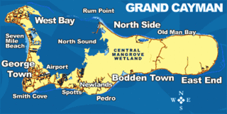
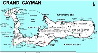
The Central Manrove Wetland is a large area of mangrove dominated wetland on Grand Cayman, one of the Cayman Islands, a British Overseas Territory in the Caribbean Sea. It is one of the territory’s Important Bird Areas (IBAs).

Crown Wetlands

The Crown Wetlands lie on Little Cayman, one of the Cayman Islands, a British Overseas Territory in the Caribbean Sea. Collectively they form one of the territory’s Important Bird Areas (IBAs).

Frank Sound Forest

Frank Sound Forest lies near the southern coast of the East End distinct of Grand Cayman, one of the Cayman Islands, a British Overseas Territory in the Caribbean Sea. It is one of the territory’s Important Bird Areas (IBAs).

Sparrowhawk Hill hill in Cayman Islands, United Kingdom

Sparrowhawk Hill lies in the centre of Little Cayman, one of the Cayman Islands, a British Overseas Territory in the Caribbean Sea. It is one of the territory’s Important Bird Areas (IBAs).

Road Salt Pond

Road Salt Pond, also known as Road Bay Pond or simply Road Pond, is a wetland in Anguilla, a British Overseas Territory in the Caribbean Sea. It is one of the territory’s Important Bird Areas (IBAs).

West End Pond

West End Pond is a wetland in Anguilla, a British Overseas Territory in the Caribbean Sea. It is one of the territory’s Important Bird Areas (IBAs).

Rendezvous Bay Pond

Rendezvous Bay Pond, also known as Rendezvous Bay Salt Pond, is a wetland in Anguilla, a British Overseas Territory in the Caribbean Sea. It is one of the territory’s Important Bird Areas (IBAs).

Meads Bay Pond

Meads Bay Pond is a wetland in Anguilla, a British Overseas Territory in the Caribbean Sea. It is one of the territory’s Important Bird Areas (IBAs).

Merrywing Pond System

The Merrywing Pond System is a golf course wetland system in Anguilla, a British Overseas Territory in the Caribbean Sea. It forms one of the territory’s Important Bird Areas (IBAs).

Forest Bay Pond

Forest Bay Pond is a small wetland in Anguilla, a British Overseas Territory in the Caribbean Sea. It forms one of the territory’s Important Bird Areas (IBAs).

Northern Forested Ghauts

The Northern Forested Ghauts constitute a tract of land on the island of Montserrat, a British Overseas Territory in the Leeward Islands of the Caribbean Sea. It forms one of the territory’s Important Bird Areas (IBAs).

South Soufriere Hills

South Soufriere Hills is a 35 ha patch of forest on the island of Montserrat, a British Overseas Territory in the Leeward Islands of the Caribbean Sea. It forms one of the territory’s Important Bird Areas (IBAs).

Fish Ponds and Crossing Place Trail Important Bird Area

The Fish Ponds and Crossing Place Trail Important Bird Area is a 1024 ha tract of land on the island of Middle Caicos in the Turks and Caicos Islands, a British Overseas Territory in the Lucayan Archipelago of the western Atlantic Ocean. It forms one of the territory’s Important Bird Areas (IBAs).

References

  1. 1 2 "Cauls Pond". Important Bird Areas factsheet. BirdLife International. 2014. Archived from the original on 2007-07-10. Retrieved 2014-04-06.

Coordinates: 18°13′23″N63°01′19″W / 18.22306°N 63.02194°W / 18.22306; -63.02194

Geographic coordinate system Coordinate system

A geographic coordinate system is a coordinate system that enables every location on Earth to be specified by a set of numbers, letters or symbols. The coordinates are often chosen such that one of the numbers represents a vertical position and two or three of the numbers represent a horizontal position; alternatively, a geographic position may be expressed in a combined three-dimensional Cartesian vector. A common choice of coordinates is latitude, longitude and elevation. To specify a location on a plane requires a map projection.