Cavitt Creek

Last updated
Cavitt Creek
Cavitt Creek Falls Recreation Site (22497563605).jpg
USA Oregon location map.svg
Red pog.svg
Location of the mouth of Cavitt Creek in Oregon
EtymologyFor Robert L. Cavitt, who settled along the creek in the mid-19th century [1]
Location
CountryUnited States
State Oregon
Region Umpqua National Forest
County Douglas
Physical characteristics
Source Cascade Range
 - locationnear Red Butte
 - coordinates 43°08′43″N122°52′18″W / 43.14528°N 122.87167°W / 43.14528; -122.87167
 - elevation4,019 ft (1,225 m) [2]
Mouth Little River
 - locationnear Peel
 - coordinates 43°14′27″N123°01′14″W / 43.24083°N 123.02056°W / 43.24083; -123.02056 Coordinates: 43°14′27″N123°01′14″W / 43.24083°N 123.02056°W / 43.24083; -123.02056 [3]
 - elevation889 ft (271 m) [3]

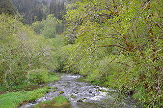
Cavitt Creek is a tributary of the Little River in Douglas County in the U.S. state of Oregon. [4] From its source near Red Butte, the creek flows generally west then north through the Umpqua National Forest of the Cascade Range before entering the river about 1.5 miles (2.4 km) upstream of the rural community of Peel and 7 miles (11 km) above the Little River's mouth on the North Umpqua River. [4]

Douglas County, Oregon County in the United States

Douglas County is a county in the U.S. state of Oregon. As of the 2010 census, the population was 107,667. The county seat is Roseburg. It is named after Stephen A. Douglas, an American politician who supported Oregon statehood.

U.S. state constituent political entity of the United States

In the United States, a state is a constituent political entity, of which there are currently 50. Bound together in a political union, each state holds governmental jurisdiction over a separate and defined geographic territory and shares its sovereignty with the federal government. Due to this shared sovereignty, Americans are citizens both of the federal republic and of the state in which they reside. State citizenship and residency are flexible, and no government approval is required to move between states, except for persons restricted by certain types of court orders. Four states use the term commonwealth rather than state in their full official names.

Oregon State of the United States of America

Oregon is a state in the Pacific Northwest region on the West Coast of the United States. The Columbia River delineates much of Oregon's northern boundary with Washington, while the Snake River delineates much of its eastern boundary with Idaho. The parallel 42° north delineates the southern boundary with California and Nevada. Oregon is one of only three states of the contiguous United States to have a coastline on the Pacific Ocean.

Contents

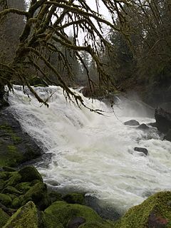
Cavitt Creek Falls Recreation Site is about 3 miles (5 km) upstream of the confluence along Cavitt Creek Road. Managed by the Bureau of Land Management, the forested site features 6-foot (1.8 m) Cavitt Creek waterfall above a swimming hole. Amenities include campsites, water spigots, parking, and restrooms, as well as proximity to fishing spots and hiking trails. The park is open from May 22 to September 26. [5]

Bureau of Land Management agency within the United States Department of the Interior

The Bureau of Land Management (BLM) is an agency within the United States Department of the Interior that administers more than 247.3 million acres (1,001,000 km2) of public lands in the United States which constitutes one-eighth of the landmass of the country. President Harry S. Truman created the BLM in 1946 by combining two existing agencies: the General Land Office and the Grazing Service. The agency manages the federal government's nearly 700 million acres (2,800,000 km2) of subsurface mineral estate located beneath federal, state and private lands severed from their surface rights by the Homestead Act of 1862. Most BLM public lands are located in these 12 western states: Alaska, Arizona, California, Colorado, Idaho, Montana, Nevada, New Mexico, Oregon, Utah, Washington and Wyoming.

Cavitt Creek Falls

Cavitt Creek Falls, is a waterfall located on the west edge of the Umpqua National Forest, outside of the town of Glide, in Douglas County, in the U.S. state of Oregon. It totals 8 feet fall in one cascade that shoots into a large swimming bowl and is the centerpiece attraction of the Cavitt Creek Falls trailhead and Recreation Site. Boulders across Cavitt Creek create two channels of water flow that make the cascade and add to a combined width of approximately 15 feet.

Bridge

Cavitt Creek Bridge carries Cavitt Creek Road over the Little River downstream of the confluence of the creek and the river. The road crosses Jim Creek, another Little River tributary, before reaching the bridge. [4]

Cavitt Creek Bridge

Cavitt Creek Bridge is a covered bridge in Douglas County in the U.S. state of Oregon. Built by Floyd C. Frear in 1943, it carries Cavitt Creek Road over the Little River about 20 miles (32 km) east of Roseburg. Cavitt Creek and the road and bridge were named for Robert L. Cavitt, who settled along the creek in the mid-19th century.

Tributaries

Named tributaries of Cavitt Creek from source to mouth are Withrow, Cultus, Liveoak, Tuttle, and Springer creeks. Further downstream come Mill, White Rock, Copperhead, Buck Peak, Buckshot, McKay, and Evans creeks. [4]

See also

Related Research Articles

Smith River (Umpqua River tributary) tributary of the Umpqua River in the U.S. state of Oregon

The Smith River is a 90-mile (140 km) tributary of the Umpqua River in the U.S. state of Oregon. It drains 352 square miles (910 km2) of the Central Oregon Coast Range between the watershed of the Umpqua to the south and the Siuslaw River to the north.

Little River (North Umpqua River tributary) tributary of the North Umpqua River in Oregon, United States of America

The Little River is a tributary of the North Umpqua River, about 30 miles (48 km) long, in southwestern Oregon in the United States. It drains part of the western side of the Cascade Range east of Roseburg, between the North and South Umpqua.

Salmon River (Clackamas County, Oregon) river in Oregons Cascade Range

The Salmon River is a 33.5-mile (53.9 km) river in the Cascade Range in the U.S. state of Oregon that drains part of southwestern Mount Hood. The entire length of the river is a protected National Wild and Scenic River. Several portions are in protected wilderness. It is affluent to the Sandy River, a tributary of the Columbia River.

Imnaha River tributary of the Snake River in Oregon

The Imnaha River is a 73.3-mile-long (118.0 km) tributary of the Snake River in the U.S. state of Oregon. Flowing generally east near the headwaters and then north through Wallowa County, the entire river is designated Wild and Scenic. It follows a geologic fault to the Snake River, and in addition to land in the Wallowa–Whitman National Forest and private land, its corridor includes parts of three special management areas: the Eagle Cap Wilderness, Hells Canyon National Recreation Area, and Hells Canyon Scenic Byway. The Imnaha flows by the unincorporated community of Imnaha, the only settlement along its course, and enters the Snake River roughly 4 miles (6 km) from the larger river's confluence with the Salmon River of Idaho and 192 miles (309 km) from its confluence with the Columbia River.

Umatilla River tributary of the Columbia River in Oregon

The Umatilla River is an 89-mile (143 km) tributary of the Columbia River in the U.S. state of Oregon. Draining a basin of 2,450 square miles (6,300 km2), it enters the Columbia near the city of Umatilla in the northeastern part of the state. In downstream order, beginning at the headwaters, major tributaries of the Umatilla River are the North Fork Umatilla River and the South Fork Umatilla River, then Meacham, McKay, Birch, and Butter creeks.

Quartzville Creek tributary of the Middle Santiam River in Oregon

Quartzville Creek is a 28-mile (45 km) tributary of the Middle Santiam River in Linn County in the U.S. state of Oregon. It is paralleled by the Quartzville Back Country Byway and used for recreation, including camping, fishing, hunting, kayaking, and gold panning. The lower 12 miles (19 km) of the creek, from the Willamette National Forest boundary to Green Peter Reservoir, was designated Wild and Scenic in 1988.

Grave Creek (Oregon) river in the United States of America

Grave Creek is a tributary, about 40 miles (64 km) long, of the Rogue River in southwestern Oregon in the United States.

Little North Santiam River river in the United States of America

The Little North Santiam River is a 27-mile (43 km) tributary of the North Santiam River in western Oregon in the United States. It drains 113 square miles (290 km2) of the Cascade Range on the eastern side of the Willamette Valley east of Salem.

Little Luckiamute River river in the United States of America

The Little Luckiamute River is a stream in Polk County in the U.S. state of Oregon. It rises in the Central Oregon Coast Range near Fanno Peak and joins the Luckiamute River about 4 miles (6 km) upstream of the Sarah Helmick State Recreation Site southwest of Monmouth.

Yakso Falls

Yakso Falls is a 70-foot (21 m) waterfall on Little River, in the Cascade Range east of Roseburg in the U.S. state of Oregon. The waterfall is about 27 miles (43 km) from the unincorporated community of Glide along Little River Road, which becomes Forest Road 27.

Mosby Creek (Oregon) river in the United States of America

Mosby Creek is a 21-mile (34 km) tributary of the Row River in Lane County, in the U.S. state of Oregon. It begins at the confluence of the east and west forks of the creek near the Calapooia Divide and the border with Douglas County. From its source it flows generally north-northwest to meet the river slightly east of Cottage Grove and about 4 miles (6 km) from the larger stream's confluence with the Coast Fork Willamette River.

North Fork Siuslaw River river in the United States of America

The North Fork Siuslaw River is a tributary of the Siuslaw River in Lane County in the United States state of Oregon. It is formed by the confluence of Sam Creek and West Branch in the Siuslaw National Forest of the Central Oregon Coast Range. The former community of Pawn was once at the juncture of the two creeks. From here, the river flows about 2 miles (3 km) southeast, then about 25 miles (40 km) southwest to meet the main stem 1.2 miles (1.9 km) east of Florence.

Crabtree Creek (South Santiam River tributary)

Crabtree Creek is a tributary of the South Santiam River in Linn County in the U.S. state of Oregon. It begins in the western foothills of the Cascade Range at Crabtree Mountain near Crabtree Lake. From there it flows generally west to meet the larger stream about 3 miles (5 km) upstream of where the South Santiam merges with the North Santiam River to form the Santiam River.

Deadwood Creek (Oregon) river in the United States of America

Deadwood Creek is a tributary of Lake Creek in the Siuslaw River basin in Lane County in the U.S. state of Oregon. Beginning near Taylor Butte in the Central Oregon Coast Range, it meanders generally southwest through the Siuslaw National Forest to meet the larger creek at the rural community of Deadwood. This is 5 miles (8 km) from Lake Creek's confluence with the river near Swisshome and 34 miles (55 km) by water from the Siuslaw River's mouth on the Pacific Ocean at Florence.

Lake Creek (Siuslaw River)

Lake Creek is a major tributary of the Siuslaw River in Lane County in the U.S. state of Oregon. On average, the 40-mile (64 km) long creek contributes about a third of the lower Siuslaw's water volume.

Fall Creek (Middle Fork Willamette River)

Fall Creek is a 34-mile (55 km) tributary of the Middle Fork Willamette River in Lane County in the U.S. state of Oregon. Beginning in the Cascade Range, the creek flows generally west through the Willamette National Forest to enter the Middle Fork upstream of Jasper, southeast of Springfield and Eugene.

Myrtle Creek (South Umpqua River tributary) river in the United States of America

Myrtle Creek is a short tributary of the South Umpqua River in Douglas County in the U.S. state of Oregon. Its main stem, formed by the confluence of two forks just south of the city of Myrtle Creek, is only about 1 mile (1.6 km) long. Its only named tributaries are the two forks, North Myrtle Creek and South Myrtle Creek, each of which is much longer than the main stem.

Ritner Creek tributary of the Luckiamute River in Polk County in the U.S. state of Oregon

Ritner Creek is a tributary of the Luckiamute River in Polk County in the U.S. state of Oregon. The creek begins near Bald Mountain in the Central Oregon Coast Range and flows generally southeast to meet the Luckiamute southwest of Pedee and north of Kings Valley. The confluence is 31 miles (50 km) upstream of the Luckiamute's mouth on the Willamette River. Named tributaries of Ritner Creek from source to mouth are Sheythe, Love, Clayton, and Kinsey creeks.

Calapooya Creek river in the United States of America

Calapooya Creek is a tributary, about 37 miles (60 km) long, of the Umpqua River in Douglas County in the U.S. state of Oregon. Formed by its north and south forks, the creek drains a mountainous region south of the Calapooya Divide and east of Oakland and Sutherlin.

References

  1. McArthur, Lewis A.; McArthur, Lewis L. (2003) [1928]. Oregon Geographic Names (7th ed.). Portland, Oregon: Oregon Historical Society Press. p. 181. ISBN   0-87595-277-1.
  2. Source elevation derived from Google Earth search using GNIS source coordinates.
  3. 1 2 "Cavitt Creek". Geographic Names Information System. United States Geological Survey. November 28, 1980. Retrieved March 22, 2016.
  4. 1 2 3 4 "United States Topographic Map". United States Geological Survey. Retrieved March 23, 2016 via Acme Mapper. The map includes mile markers along the Little River.
  5. "Cavitt Creek Recreation Site". Bureau of Land Management. Retrieved March 23, 2016.