Caxcan

Last updated
Caxcan
Cazcan
Guerra de juchipila.jpg
Caxcan warriors battling against the Spaniards
Total population
Unknown
Regions with significant populations
Western and North-Central Mexico
Languages
Caxcan and Spanish
Related ethnic groups
Other Chichimecas
Map of the Caxcan and surrounding nations during the 16th century ChichimecNations.png
Map of the Caxcan and surrounding nations during the 16th century

The Caxcan are an ethnic group who are indigenous to western and north-central Mexico, particularly the regions corresponding to modern-day Zacatecas, southern Durango, Jalisco, Colima, Aguascalientes, Nayarit. The Caxcan language is most often documented as an ancient variant of Nahuatl and is a member of the Uto-Aztecan language family. The last generation of natively fluent Caxcan language speakers came to an end in the 1890s. Despite this having long been conflated by anthropologists with an extinction of the Caxcan people themselves, much of Caxcan culture has persisted via oral tradition. There is currently an ongoing revitalization of Caxcan language, scholarship, and culture. [1]

Contents

History

Pre-1550

The Caxcan were a partly nomadic, partly sedentary people. Under their leader, Tenamaztle, the Caxcan were allied with the Zacatecos against the Spaniards during the Mixtón Rebellion in 1540-42. During the rebellion, they were described as "the heart and the center of the Indian Rebellion". After the rebellion, they were a constant target of the Zacatecos and Guachichiles due to their ceasefire agreement with the Spaniards. Their principal religious and population centers were at Teul, Tlaltenango, Juchipila, and Teocaltiche.

Over time, the Caxcans lost their culture due to warfare, disease, and marriage to non-Caxcans. Also, most of the Caxcans were sent into slavery by the Spanish to work in silver mines. During the colonial period, many Spanish (and some Basque settlers) had intermarried, or had relations, with the Caxcans making many Caxcan descendants Mestizos. The allied tribes and Mestizos settled the Caxcan lands in Zacatecas and Jalisco.

Their elected rulers were called tlatoani. Caxcan society was divided up into several different city-states.
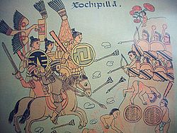
The Chichimeca War (1550-1590)

The Chichimeca War (15501590) was a military conflict waged between Spanish colonizers and their Indian allies against a confederation of Chichimeca Indians. It was the longest and most expensive conflict between Spaniards and the indigenous peoples of New Spain in the history of the colony. [2]

The Chichimeca wars began eight years after the Mixtón Rebellion (1540–1542). It can be considered as a continuation of that rebellion as the fighting did not come to a halt in the intervening years. Unlike in the Mixtón rebellion, the Caxcanes were now allied with the Spanish. The war was fought in the Bajío region known as La Gran Chichimeca, specifically in the Mexican states of Zacatecas, Guanajuato, Aguascalientes, Jalisco, and San Luis Potosi.

1900-2000

The Council of the Caxcan indigenous people was formed in the 1920s by Juana Belén Gutiérrez de Mendoza, a Caxcan from Durango. [3] She also published Alto!, a book which stressed Mexican Nationalism through indigenous roots and, even after the alleged extinction of the Caxcan people, is quoted as saying "We do not recognize the right of any race to impose its civilization upon us" as a way to promote indigeneity.

2000-Present

Caxcan people continue to live in Zacatecas and in diaspora. They are currently attempting to regain legal access to their sacred mountain, Tlachialoyantepec (El Cerro de las Ventanas). [4] [3]

Notes

  1. Luna, Jennie; Estrada, Gabriel S. (2020). "Trans*lating the Genderqueer -X through Caxcan, Nahua, and Xicanx Indígena Knowledge". In Aldama, Arturo J.; Luis Aldama, Frederick (eds.). Decolonizing Latinx Masculinities. University of Arizona Press. pp. 251–268. ISBN   9780816541836.
  2. LatinoLA | Comunidad :: The Indigenous People of Zacatecas
  3. 1 2 Pouwels, Joel Bollinger. Political Journalism by Mexican Women During the Age of Revolution 1876-1940. New York: Edwin Mellen P, 2006]
  4. https://uapress.arizona.edu/book/where-we-belong

Related Research Articles

<span class="mw-page-title-main">Nueva Galicia</span> Province & Indendancy in New Spain, Spain

Nuevo Reino de Galicia or simply Nueva Galicia was an autonomous kingdom of the Viceroyalty of New Spain. It was named after Galicia in Spain. Nueva Galicia's territory consisted of the present-day Mexican states of Aguascalientes, Guanajuato, Colima, Jalisco, Nayarit and Zacatecas.

<span class="mw-page-title-main">Totatiche</span> Place in Jalisco, Mexico

The municipality and town of Totatiche is located in the northern extreme of the state of Jalisco, Mexico between 21°48’30” and 22°06’00” latitude north and 103°20’00” and 103°34’00” longitude east at a height of 1,751 meters (5,745 ft) above sea level. The municipality is bordered on the north and southeast by the state of Zacatecas. On the northeast, it shares its border with the municipality of Colotlán and on the west it is bordered by the municipalities of Villa Guerrero and Chimaltitán.

The Tlaxcalans, or Tlaxcaltecs, are a Nahua people who live in the Mexican state of Tlaxcala.

<span class="mw-page-title-main">Tepehuán</span>

The Tepehuán are an indigenous people of Mexico. They live in Northwestern, Western, and some parts of North-Central Mexico. The indigenous Tepehuán language has three branches: Northern Tepehuan, Southeastern Tepehuan, Southwestern Tepehuan. The heart of the Tepehuan territory is in the Valley of Guadiana in Durango, but they eventually expanded into southern Chihuahua, eastern Sinaloa, and northern Jalisco, Nayarit, and Zacatecas. By the time of the Spanish conquest of the Aztec Empire, Tepehuan lands spanned a large territory along the Sierra Madre Occidental. Tepehuán groups are divided into the Ódami, Audam, and O'dam, each with their own language, culture, and beliefs.

<span class="mw-page-title-main">Zacateco</span>

The Zacatecos is the name of an indigenous group, one of the peoples called Chichimecas by the Aztecs. They lived in most of what is now the state of Zacatecas and the northeastern part of Durango. They have many direct descendants, but most of their culture and traditions have disappeared with time. Large concentrations of modern-day descendants may reside in Zacatecas and Durango, as well as other large cities of Mexico.

<span class="mw-page-title-main">Guachichil</span> Ethnic group of Mexico

The Guachichil, Cuauchichil, or Quauhchichitl, are an Indigenous people of Mexico. Pre-contact, they occupied the most extensive territory of all the indigenous Chichimeca Nations tribes in pre-Columbian Central Mexico.

<span class="mw-page-title-main">Mixtón War</span> War (1540–1542) between Caxcan and Spanish conquerors

The Mixtón War (1540-1542) was a rebellion by the Caxcan people of northwestern Mexico against the Spanish conquerors. The war was named after Mixtón, a hill in Zacatecas which served as an Indigenous stronghold.

<span class="mw-page-title-main">Chichimeca War</span> 16th-century Spanish invasion of Mesoamerica

The Chichimeca War (1550–90) was a military conflict between the Spanish Empire and the Chichimeca Confederation established in the territories today known as the Central Mexican Plateau, called by the Conquistadores La Gran Chichimeca. The epicenter of the hostilities was the region now called the Bajío. The Chichimeca War is recorded as the longest and most expensive military campaign confronting the Spanish Empire and indigenous people in Mesoamerica. The forty-year conflict was settled through several peace treaties driven by the Spaniards which led to the pacification and, ultimately, the streamlined integration of the native populations into the New Spain society.

<span class="mw-page-title-main">Tlaltenango de Sánchez Román Municipality</span> Place in Zacatecas, Mexico

Tlaltenango de Sánchez Román is a municipality located in the southwestern portion of the Mexican state of Zacatecas. The average elevation of the municipality is 1,723 meters (5,653 ft) above sea level and the municipality covers an area of 808.082 square kilometres (312.002 sq mi). The municipality lies in a valley bordered by the Sierra de Morones and lies on the banks of the Tlaltenango River, which runs north and is a tributary of the Bolaños River.

<span class="mw-page-title-main">Guamare</span>

The Guamare people were an indigenous people of Mexico, who were established mostly in Guanajuato and at the border of Jalisco. They were part of the Chichimecas, a group of a nomadic hunter-gatherer culture and called themselves Children of the Wind, living religiously from the natural land. As a tradition, they would cremate their dead and spread their ashes into the wind back to 'Mother Earth'. The Guamare people were politically united with the Chichimeca Confederation, but like other Chichimeca nations were independent. The Chichimeca were established in the present-day Bajio region of Mexico.

<span class="mw-page-title-main">Tecuexe</span>

The Tecuexe were an indigenous peoples of Mexico, who lived in the eastern part of present-day Guadalajara.

Jalpa is a town located in the Mexican state of Zacatecas, close to the border with Jalisco and Aguascalientes and about a two hours drive south of the capital city, Zacatecas. Jalpa is a colonial-style city, with cobble stone streets, narrow walkways, two main churches: El Señor de Jalpa and La Parroquia de San Antonio, and two plazas. Jalpa was modeled by the French in the 19th century. In the middle of the plaza is a kiosk which remains in good shape today, after hundreds of years. Most houses are painted in bright colors just as in colonial times. The houses are made of adobe and share common walls and most have flat roofs.

Cristóbal de Oñate was a Spanish Basque explorer, conquistador and colonial official in New Spain. He is considered the founder of the contemporary city of Guadalajara in 1531, as well as other places in Nueva Galicia.

<span class="mw-page-title-main">Colotlán</span> Municipality and town in Jalisco, Mexico

The municipality of Colotlán is in the northern extremity of the Mexican state of Jalisco. The municipality covers an area of approximately 648 square kilometers. Colotlán is located at 22°12′N103°18′W. It stands at 1,550 metres (5,090 ft) above sea level.

<span class="mw-page-title-main">Tepehuán Revolt</span>

The Tepehuán Revolt broke out in New Spain in 1616 when the indigenous Tepehuán attempted to break free from Spanish rule. The revolt was crushed by 1620 after a large loss of life on both sides.

<span class="mw-page-title-main">Zacatecas</span> State of Mexico

Zacatecas, officially the Free and Sovereign State of Zacatecas, is one of the 31 states of Mexico. It is divided into 58 municipalities and its capital city is Zacatecas.

<span class="mw-page-title-main">Francisco Tenamaztle</span>

Francisco Tenamaztle, also Tenamaxtlan, Tenamaxtli or Tenamaxtle, was a leader of the Caxcan indigenous peoples in Mexico during the Mixtón War of 1540–1542. He was later put on trial in Spain. With the support of Bartolomé de las Casas he defended the justice of his cause by appealing to King Carlos I.

<span class="mw-page-title-main">El Teúl</span>

El Teúl is an important archaeological Mesoamerican site located on a hill with the same name in the Teúl Municipality in the south of the Zacatecas State, Mexico, near the Jalisco State.

<span class="mw-page-title-main">Hernando Martel</span>

Hernando Martel was a Spanish conquistador, judge, politician and military officer, born in Seville, Spain. He conquered and pacified much of the region known today as Lagos de Moreno.