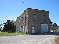
Cedar, Iowa

Last updated
Cedar, Iowa
Cedar Iowa.JPG
Cedar Hall
USA Iowa location map.svg
Red pog.svg
Cedar
Usa edcp location map.svg
Red pog.svg
Cedar
Coordinates: 41°12′44″N92°31′33″W / 41.21222°N 92.52583°W / 41.21222; -92.52583 Coordinates: 41°12′44″N92°31′33″W / 41.21222°N 92.52583°W / 41.21222; -92.52583
Country United States
State Iowa
County Mahaska
Elevation
814 ft (248 m)
Time zone UTC-6 (Central (CST))
  Summer (DST) UTC-5 (CDT)
ZIP code
52543 [1]
Area code 641
GNIS feature ID455220 [2]

Cedar is an unincorporated community in southeastern Mahaska County, Iowa, United States. It lies along Iowa Highway 23 southeast of the city of Oskaloosa, the county seat of Mahaska County. [3]

Cedar has a Methodist church, Christian Reformed church, and a grain elevator.

History

A post office opened in 1874. [4]

The Burlington and Western Railway arrived in Cedar in late 1882. This was a narrow gauge line, widened to standard gauge in 1902 and taken over by the Chicago, Burlington and Quincy. the Burlington line was abandoned in 1934. [5]

Cedar's population was 53 in 1925. [6]

Related Research Articles

Pekin is a small unincorporated community in northwestern Jefferson County, Iowa, United States.

Dewar is an unincorporated town in eastern Black Hawk County, Iowa, United States. It lies northeast of the city of Waterloo, the county seat of Black Hawk County. Its elevation is 889 feet (271 m). Although Dewar is unincorporated, it has a post office with the ZIP code of 50623, which opened on 25 October 1887.

Selma is an unincorporated community in northwestern Van Buren County, Iowa, United States. It lies along Iowa Highway 16 northwest of the city of Keosauqua, the county seat of Van Buren County. Its elevation is 617 feet (188 m).

Sperry is an unincorporated community in central Des Moines County, Iowa, United States. It lies along local roads north of the city of Burlington, the county seat of Des Moines County. Its elevation is 751 feet (229 m). Although Sperry is unincorporated, it has a post office with the ZIP code of 52650, which opened on 5 February 1870.

Killduff is an unincorporated community in southeastern Jasper County, Iowa, United States. It lies along local roads southeast of the city of Newton, the county seat of Jasper County.

Oran is an unincorporated community in southwestern Fayette County, Iowa, United States. It lies along local roads southwest of the city of West Union, the county seat of Fayette County, and west of the city of Oelwein, the largest city in Fayette County. Its elevation is 1,043 feet (318 m). Although Oran is unincorporated, it has a post office with the ZIP code of 50664.

Conroy is an unincorporated community and census-designated place (CDP) in central Iowa County, Iowa, United States. It lies along local roads southeast of the city of Marengo, the county seat of Iowa County. Its elevation is 879 feet (268 m). Conroy has a post office with the ZIP Code of 52220, which opened on 5 January 1885. As of the 2010 census the population was 259.

<span class="mw-page-title-main">Austinville, Iowa</span> Unincorporated community in Iowa, United States

Austinville is an unincorporated community in southwestern Butler County, Iowa, United States. It lies along Iowa Highway 57 southwest of the city of Allison, the county seat of Butler County. Its elevation is 1,001 feet (305 m). Although Austinville is unincorporated, it has a post office with the ZIP code of 50608, which opened on 3 October 1892. In 2022, the population was 100 in town and the surrounding area.

Prole is an unincorporated rural village in northwestern Warren County, Iowa, United States. It lies along Iowa Highway 28 northwest of the city of Indianola, the county seat of Warren County. Its elevation is 978 feet (298 m). Prole has a post office, with the ZIP code of 50229, a cafe, a floral shop and an auto repair shop by way of businesses and services.

Teeds Grove is an unincorporated community in northeastern Clinton County, Iowa, United States. It lies at the intersection of Clinton County Routes E44 and Z50, north of the city of Clinton, the county seat of Clinton County. Its elevation is 692 feet (211 m).

Little Cedar is an unincorporated community and census-designated place in central Mitchell County, Iowa, United States. As of the 2020 census it had a population of 64. Little Cedar has a post office with the ZIP code of 50454.

Pilot Grove is an unincorporated community in northern Lee County, Iowa, United States. It lies along local roads northwest of the city of Fort Madison, the county seat of Lee County. Its elevation is 643 feet (196 m).

Centerdale is an unincorporated community in Cedar County, Iowa, United States.

Crocker is an unincorporated community in Polk County in the U.S. state of Iowa.

Galbraith is an unincorporated community in Kossuth County, in the U.S. state of Iowa.

Lawn Hill is an unincorporated community in Hardin County, in the U.S. state of Iowa.

Maple River is an unincorporated community in Carroll County, in the U.S. state of Iowa.

Tioga is an unincorporated community in Mahaska County, in the U.S. state of Iowa.

Wright is an unincorporated community in Mahaska County, in the U.S. state of Iowa.

Union Mills is an unincorporated community in Mahaska County, in the U.S. state of Iowa.

References

  1. "Cedar ZIP Code". zipdatamaps.com. 2022. Retrieved November 11, 2022.
  2. U.S. Geological Survey Geographic Names Information System: Cedar, Iowa
  3. Rand McNally. The Road Atlas '08. Chicago: Rand McNally, 2008, p. 39.
  4. U.S. Geological Survey Geographic Names Information System: Cedar Post Office
  5. David Lotz and Charles Franzen, 'Rails to a County Seat', The Print Shop, Washington Iowa, 1989; pages 37, 47-52.
  6. Company, Rand McNally and (1925). Premier Atlas of the World: Containing Maps of All Countries of the World, with the Most Recent Boundary Decisions, and Maps of All the States,territories, and Possessions of the United States with Population Figures from the Latest Official Census Reports, Also Data of Interest Concerning International and Domestic Political Questions. Rand McNally & Company. p. 190.