Related Research Articles

The Polish Corridor, also known as the Danzig Corridor, Corridor to the Sea or Gdańsk Corridor, was a territory located in the region of Pomerelia, which provided the Second Republic of Poland (1920–1939) with access to the Baltic Sea, thus dividing the bulk of Weimar Germany from the province of East Prussia. At its narrowest point, the Polish territory was just 30 km wide. The Free City of Danzig, situated to the east of the corridor, was a semi-independent German speaking city-state forming part of neither Germany nor Poland, though united with the latter through an imposed union covering customs, mail, foreign policy, railways as well as defence.

The Partitions of Poland were three partitions of the Polish–Lithuanian Commonwealth that took place toward the end of the 18th century and ended the existence of the state, resulting in the elimination of sovereign Poland and Lithuania for 123 years. The partitions were conducted by the Habsburg monarchy, the Kingdom of Prussia, and the Russian Empire, which divided up the Commonwealth lands among themselves progressively in the process of territorial seizures and annexations.

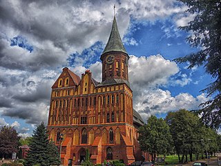
East Prussia was a province of the Kingdom of Prussia from 1772 to 1829 and again from 1878 ; following World War I it formed part of the Weimar Republic's Free State of Prussia, until 1945. Its capital city was Königsberg. East Prussia was the main part of the region of Prussia along the southeastern Baltic Coast.
Prussia is a historical region in Central Europe on the south-eastern coast of the Baltic Sea, that ranges from the Vistula delta in the west to the end of the Curonian Spit in the east and extends inland as far as Masuria, divided between Poland, Russia and Lithuania.

Bartoszyce is a town on the Łyna River in northern Poland, with 22,597 inhabitants as of December 2021. It is the capital of Bartoszyce County within the Warmian-Masurian Voivodeship.

Augustów is a town in north-eastern Poland. It lies on the Netta River and the Augustów Canal. It is the seat of Augustów County and of Gmina Augustów in the Podlaskie Voivodeship. Augustów has an area of 80.90 square kilometres, and as of June 2022 it has a population of 29,305.

Hajnówka is a town and a powiat seat in eastern Poland with 21,442 inhabitants (2014). It is the capital of Hajnówka County. The town is also notable for its proximity to the Białowieża Forest, the biggest primaeval forest in Europe. Through Hajnówka flows the river Leśna Prawa. It is one of the centres of Orthodox faith and a notable centre of Belarusian culture in Poland. Belarusians comprised 26.4% of the town's population in 2002.

Suraż is a town in north-eastern Poland situated in the Podlaskie Voivodeship, seat of Gmina Suraż in the Białystok County.

Galicia is a historical and geographic region spanning what is now southeastern Poland and western Ukraine, long part of the Polish–Lithuanian Commonwealth. It covers much of the other historic regions of Red Ruthenia and Lesser Poland.

Kuyavia, also referred to as Cuyavia, is a historical region in north-central Poland, situated on the left bank of Vistula, as well as east from Noteć River and Lake Gopło. It is divided into three traditional parts: north-western, central, and south-eastern.

The Neumark, also known as the New March or as East Brandenburg, was a region of the Margraviate of Brandenburg and its successors located east of the Oder River in territory which became part of Poland in 1945 except some villages of former districts of Königsberg in the New March and Weststenberg remained in Germany.

Suwałki Region is a historical region around the city of Suwałki in northeastern Poland near the border with Lithuania. It encompasses the powiats of Augustów, Suwałki, and Sejny, and roughly corresponds to the southern part of the former Suwałki Governorate.

Radziejów is a town in Poland, in Kuyavian-Pomeranian Voivodeship, about 45 km south of Toruń. It is the capital of Radziejów County. Its population is 5,696 (2010).

Skarszewy is a small town in Starogard Gdański County, Pomeranian Voivodeship, northern Poland. It is located within the ethnocultural region of Kociewie, 40 kilometres south of Gdańsk. Population: 6 809. In 2005 the town was given the title the Pearl of Pomerania. It is the seat of the urban-rural administrative district Gmina Skarszewy.

Wojciech Kętrzyński, was a Polish historian and the director of the Ossolineum Library in Lemberg, then the capital of Galicia, Austrian Empire. He focused on Polish history at a time when Poland was partitioned between foreign powers. He opposed the idea of Germanization and assisted in the January Uprising for Poland's cause. In 1861 he legally changed his name and became a Polish national.

Biała Piska is a town in Pisz County, Warmian-Masurian Voivodeship, Poland, with 3,986 inhabitants as of December 2021.

Pobiedziska is a town in Poznań County, Poland, with 8,209 inhabitants as of the year 2004. It is also the seat of the administrative district (gmina) called Gmina Pobiedziska.

Raszków is a town in Ostrów Wielkopolski County, Greater Poland Voivodeship, Poland, with 2,080 inhabitants (2010).
Kcynia is a town in Nakło County, Kuyavian-Pomeranian Voivodeship, in north-central Poland, with 4,702 inhabitants (2010). It is located in the Pałuki ethnographic region in the northern part of historic Greater Poland.

Świekatowo is a village in Świecie County, Kuyavian-Pomeranian Voivodeship, in north-central Poland. It is the seat of the gmina called Gmina Świekatowo. It lies approximately 23 kilometres (14 mi) west of Świecie and 35 km (22 mi) north of Bydgoszcz. It is located in the Tuchola Forest in the historic region of Pomerania.
References
- (in Polish) Joanna Strzelecka, Powszechne spisy ludności, Kancelaria Sejmu, Biuro Studiów i Ekspertyz, Informacja Nr 890, 4/2002
| | This Poland-related article is a stub. You can help Wikipedia by expanding it. |