External links
| Cities |  | |
|---|---|---|
| Local councils | ||
| Regional councils | ||
| See also | ||
| ||
| International | |
|---|---|
| National | |
Central Arava Regional |
|---|
مجلس إقليمي عربة الوسطى
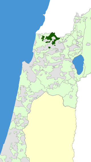
| settlement_type = Regional council (from 1976) | translit_lang1 = Hebrew | translit_lang1_type2 = Translit. | translit_lang1_info2 = Mo'atza Azorit HaArava HaTikhona | image_map = Israel Map - Central Arava Regional Council Zoomin.svg | coordinates = 30°48′00″N35°15′00″E / 30.800°N 35.250°E | subdivision_type1 = | subdivision_name1 = | subdivision_type2 = District | subdivision_name2 = Southern | established_title = Founded | established_date = 1977 | leader_title = Head of Municipality | leader_name = Meir Tzur | unit_pref = dunam | area_total_dunam = 1400000 | population_total = 2,700 | population_as_of = 2009 | population_density_km2 = auto }}
The Central Arava Regional Council (Hebrew : מועצה אזורית הערבה התיכונה) is a Regional Council in the South District of Israel.
It encompasses eight settlements near the eastern border of Israel, south of the Dead Sea. All settlements are located near Route 90, which is the longest north–south road in Israel.
The Central Arava Regional Council comprises five moshavim and three community settlements:
| Cities | | |
|---|---|---|
| Local councils | ||
| Regional councils | ||
| See also | ||
| ||
| International | |
|---|---|
| National | |

The Southern District is one of Israel's six administrative districts, the largest in terms of land area but the most sparsely populated. It covers most of the Negev desert, as well as the Arava valley. The population of the Southern District is 1,086,240 and its area is 14,185 km2. Its population is 79.66% Jewish and 12.72% Arab, with 7.62% of other origins.

Giv'at Ze'ev is an urban Israeli settlement in the West Bank, five kilometers northwest of Jerusalem. The settlement was founded in 1977 on the site of the abandoned Jordanian military camp, adjacent to the site of ancient Gibeon. While it lies within the borders of the Matte Binyamin Regional Council, it is a separate municipal entity. In 2021 it had a population of 20,034.

Neot Smadar is a kibbutz in southern Israel. Located in the Arava Desert, it falls under the jurisdiction of Hevel Eilot Regional Council. Its area is 80 hectares. In 2021 it had a population of 227.

Gesher is a kibbutz in the Beit She'an Valley in northeastern Israel. Founded in 1939 by Jewish refugees from Germany, it falls under the jurisdiction of Valley of Springs Regional Council. It is situated 10 km south of kibbutz Deganya Aleph and 15 km south of Tiberias. The population is approximately 500 inhabitants.

The Mateh Asher Regional Council is a regional council in the western Galilee of northern Israel. It is named after the Tribe of Asher which had been allotted the region in antiquity according to the Book of Joshua (19:24–31). It was founded in 1982 as a merger of three regional councils: Ga'aton, Na'aman and Sulam Tzor. The council's offices are located on Highway 4, between Regba and Lohamei HaGeta'ot.
The Ma'ale Yosef Regional Council is a regional council in the Upper Galilee, part of the Northern District of Israel, situated between the towns of Ma'alot-Tarshiha and Shlomi. Its offices are located in Gornot HaGalil.

Ramat HaNegev Regional Council is a regional council in the Negev desert in Israel. With around 8,000 residents spread across 20 villages, the council is geographically the largest in Israel, covering more than 20% of Israel's landmass. The council's headquarters are located on Highway 40 between Mashabei Sadeh and Tlalim.

The Tamar Regional Council is a regional council in Israel's Southern District, on the south and western edges of the Dead Sea along the Arava valley. The council was established in 1955 with the opening of lodging at Sodom near the Dead Sea Works, and its jurisdiction covers an area of 1,650 km2.
Beit HaArava is an Israeli settlement and kibbutz in the West Bank. Located near the Dead Sea and Jericho at the eponymous Beit HaArava Junction, the intersection of Highway 1 and Highway 90, it falls under the jurisdiction of Megilot Regional Council. In 2021 it had a population of 451.
Gederot Regional Council is a regional council in the Central District of Israel. It is located between Ashdod, Yavne and Gedera and covers an area of 13,000 dunams. Founded in 1953, it was named after a biblical town in the allotment of the tribe of Judah Its population is 4,200.

Hevel Eilot Regional Council is a regional council in the Southern District of Israel, near the city of Eilat. It is the southernmost regional council in Israel.
Megilot Regional Council, also Megilot Dead Sea Regional Council, is a regional council in the Judean Desert of the West Bank, near the western shores of the Dead Sea. It covers six Israeli settlements. With only about 1,400 residents, it is Israel's smallest regional council. Its municipal offices are located in Vered Yeriho.

Almog is an Israeli settlement in the West Bank, near the northwestern shores of the Dead Sea, in the Jordan Rift Valley, organized as a kibbutz. It is under the jurisdiction of the Megilot Regional Council. In 2021 its population was 255. The international community considers Israeli settlements in the West Bank illegal under international law, but the Israeli government disputes this.

Pardesiya is a town in the Central District of Israel. Located on the Sharon plain, between Kfar Yona and the Lev HaSharon Regional Council, it was founded between 1937 and 1939. In 2021 it had a population of 7,251; its jurisdiction is 1,273 dunams (~1.3 km2)
Elyakhin is a town and local council in the Central District of Israel. Located just south of Hadera and bordering the Emek Hefer Regional Council, it is accessible by local road 5812. With a jurisdiction of 1,600 dunams, it had a population of 3,461 in 2021.

Lev HaSharon Regional Council is a regional council in the Central District of Israel.

Yokneam is a moshava in the Northern District of Israel. Located on the outskirts of the city of Yokneam Illit on the border of the Jezreel Valley and the Menashe Heights, it falls under the jurisdiction of the Megiddo Regional Council and is administrated by a local committee which is elected every five years. In 2021 it had a population of 1,376.

Petza'el is a moshav and Israeli settlement in the West Bank. Located in the center of the Jordan Valley, 34.5 kilometers from the Green line, it falls under the jurisdiction of Bik'at HaYarden Regional Council. In 2021 it had a population of 361. It is named for Phasael, older brother of Herod the Great, for whom he had named a city nearby in ancient times.

Halamish, also known as Neveh Tzuf, is an Israeli settlement in the West Bank, located in the southwestern Samarian hills to the north of Ramallah, 10.7 kilometers east of the Green line. The Orthodox Jewish community was established in 1977. It is organised as a community settlement and falls under the jurisdiction of Mateh Binyamin Regional Council. In 2021 it had a population of 1,543.
The Korazim Plateau, is a volcanic plateau, located in northern Israel. The plateau is bounded between by the Hula Valley in the north, Sea of Galilee in the south, the mountains of the Galilee to the west and by the Jordan River to the east. It is named after an ancient Jewish settlement also known as "Chorazin". The highest point is Filon Hill, which is 409 meters above sea level.