Central Mexican wetlands

Last updated
Central Mexican wetlands
Lago de patzcuaro.png
Ecology
Realm Neotropical
Biome flooded grasslands and savannas
Geography
Area260 km2 (100 sq mi)
Country Mexico
States
Conservation
Conservation status Critical/endangered [1]
Protected100%

The Central Mexican wetlands is a flooded grasslands and savannas ecoregion in central Mexico.

Contents

Geography

The Central Mexican wetlands include of several wetland areas where the southern Central Mexican Plateau meets Trans-Mexican Volcanic Belt, an east–west range of volcanic and folded mountains in central Mexico. [ citation needed ]It consists of several distinct wetland areas:

Lakes Pátzcuaro and Cuitzeo have in the past been connected to the Lerma River system. [1]

Climate

The climate is temperate, with rainfall occurring mostly in the summer. The lower portions of the ecoregion are subhumid, becoming humid at higher elevations in the south. [1]

Flora

The natural vegetation is dense reeds and cattails over two meters tall. Dominant wetland plants include species of Typha, Scirpus, Heleocharis , and Cyperus . Aquatic plants in the lakes and channels include Potamogeton illinoensis, Scirpus pectinatus , tule ( Typha latifolia ), cattail ( Typha domingensis ), and Nymphaea mexicana . [1] The willow Salix bonplandiana , known as ahuejote, is a characteristic wetland tree. [4]

The surrounding terrestrial vegetation consists of mostly of xeric scrub – the Bajío dry forests around Lake Cuitzeo, and the Central Mexican matorral in the Valley of Toluca and Valley and Mexico – and pine and oak forests intertwined with xeric scrub around Lake Pátzcuaro. [1]

Fauna

The ecoregion is important habitat for birds. About 200 species are found in the wetlands, including resident and migratory land birds and waterbirds. [1] The black-polled yellowthroat (Geothlypis speciosa) is endemic. Two other endemic species are likely extinct; the yellow rail (Coturnicops noveboracensis) has not been seen since 1964, and the slender-billed grackle (Quiscalus palustris) has not been seen since the early 20th century. The ecoregion corresponds to the Central Mexican marshes endemic bird area. [5]

The Lake Pátzcuaro salamander (Ambystoma dumerilii) is endemic to Lake Patzcuaro, [1] and the axolotl salamander (Ambystoma mexicanum) is endemic to Valley of Mexico's wetlands.

The wetlands support aquatic life. Some commercially-important fish depend on wetlands at one or more of their life stages. Native fish species of the wetlands include the hooded sawfin ( Skiffia lermae ), Alloophorus robustus, Goodea atripinnis, Neophorus diazi , and ‘pescado blanco’ ( Chirostoma estor ). [1]

Conservation and threats

The wetlands have been greatly reduced in extent, and the remaining wetlands face numerous threats. Mexico City expanded over most of the former wetland areas in the Valley of Mexico. Water diversion from the upper Lerma River to serve Mexico City and Toluca has reduced freshwater flows into the Ciénegas de Lerma. Evaporation currently exceeds inflows into the closed basin lakes, causing them to recede. Water pollution and siltation also threaten the marshes. [1]

Protected areas

The Ciénegas del Lerma was designated a flora and fauna protection area in 2002, and a Ramsar site (wetland of international importance) in 2004. [2] 707 hectares of wetland at the southeastern end of Lake Pátzcuaro, known as the Humedales del Lago de Pátzcuaro, was designated a Ramsar site in 2005. [3]

Some canals and chinampas (floating gardens), remnants of former Lake Xochimilco, are preserved in Xochimilco Ecological Park and Plant Market in the Xochimilco neighborhood of Mexico City. The Xochimilco wetlands are a World Heritage Site, and 2,657 hectares were designated a Ramsar site in 2004. [4]

Related Research Articles

<span class="mw-page-title-main">Lake Texcoco</span> Former lake in Valley of Mexico

Lake Texcoco was a natural lake within the Anahuac or Valley of Mexico. Lake Texcoco is best known for an island situated on the western side of the lake where the Mexica built the city of Mēxihco Tenōchtitlan, which would later become the capital of the Aztec Empire. After the Spanish conquest, efforts to control flooding led to most of the lake being drained.

<span class="mw-page-title-main">Cuatro Ciénegas</span> City in the Mexican state of Coahuila

Cuatro Ciénegas is a city in the northern Mexican state of Coahuila. It stands at 26°59′N102°03′W, at an average elevation of 740 metres (2,430 ft) above sea level. The city serves as the municipal seat for the surrounding municipality of the same name.

<span class="mw-page-title-main">Lake Xochimilco</span> Body of water in Mexico City

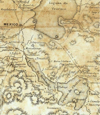
Lake Xochimilco is an ancient endorheic lake, located in the present-day Borough of Xochimilco in southern Mexico City. It is the last remaining habitat of the axolotl.

<span class="mw-page-title-main">Lake Chalco</span>

Lake Chalco was an endorheic lake formerly located in the Valley of Mexico, and was important for Mesoamerican cultural development in central Mexico. The lake was named after the ancient city of Chalco on its former eastern shore.

<span class="mw-page-title-main">Lake Pátzcuaro</span> Lake in Mexico

Lake Pátzcuaro is a lake in the municipality of Pátzcuaro, Michoacán, Mexico.

The Lake Lerma salamander is an extremely rare, occasionally neotenic mole salamander species from Mexico.

<span class="mw-page-title-main">Lerma River</span> River in Mexico

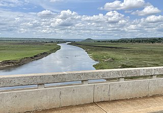
The Lerma River is Mexico's second longest river.

<span class="mw-page-title-main">Lake Cuitzeo</span> Lake in Michoacán State, Mexico

Lake Cuitzeo is a lake in the central part of Mexico, in the state of Michoacán. It has an area of 300–400 km2 (120–150 sq mi). The lake is astatic, meaning the volume and level of water in the lake fluctuates frequently. It is the second-largest freshwater lake in Mexico.

<span class="mw-page-title-main">Trans-Mexican Volcanic Belt pine–oak forests</span> Tropical and subtropical coniferous forests ecoregion in Mexico

The Trans-Mexican Volcanic Belt pine–oak forests is a subtropical coniferous forest ecoregion of the Trans-Mexican Volcanic Belt of central Mexico.

<span class="mw-page-title-main">Malagarasi River</span> River in Tanzania, Burundi

The Malagarasi River is a river in western Tanzania, flowing through Kigoma Region, although one of its tributaries comes from southeastern Burundi. The river also forms the western border of Tabora Region, the southern border of Kagera Region and the southwestern border of Geita Region. It is the second-longest river in Tanzania behind the Rufiji—Great Ruaha, and has the largest watershed of any river flowing into Lake Tanganyika. The Malagarasi-Muyovozi Wetlands are a designated a Ramsar site. Local tribes have nicknamed the Malagarasi as "the river of bad spirits".

<span class="mw-page-title-main">Río Pilcomayo National Park</span> National park in Argentina

The Río Pilcomayo National Park is a national park located in the northeastern part of the Argentine province of Formosa, on the border with Paraguay. Established on September 29, 1951 to protect the natural features, typical of the Humid Chaco ecoregion, the park is included in the Ramsar Convention's list of wetlands of international importance.

<span class="mw-page-title-main">Central Mexican matorral</span> Xeric shrubland ecoregion in Mexico

The Central Mexican matorral is an ecoregion of the deserts and xeric shrublands biome of central Mexico. It is the southernmost ecoregion of the Nearctic realm.

<span class="mw-page-title-main">Oriental Basin</span>

The Oriental Basin, also known as the Libres-Oriental Basin, Oriental-Serdán Basin or San Juan Plains, is an endorheic basin in east-central Mexico. It covers an area of 4,958.60 square kilometers, lying in the states of Puebla, Tlaxcala, and Veracruz.

<span class="mw-page-title-main">Bajío dry forests</span> Tropical dry broadleaf forest ecoregion in Mexico

The Bajío dry forests is a tropical dry broadleaf forest ecoregion in western−central Mexico.

<span class="mw-page-title-main">Lake Zirahuén</span> Endorheic lake in Michoacán, Mexico

Lake Zirahuén is a small endorheic lake in the municipality of Santa Clara del Cobre in Michoacán, Mexico. It is a deep mountain lake with a sandy bottom that is partially covered with mud. It covers an area of 970 hectares and has a volume of 0.216 cubic kilometres (0.052 cu mi).

The Whitlock Valley is a small valley in southeast Graham County, Arizona, southwestern United States, lying between three mountain ranges. The valley lies on the south perimeter region of the White Mountains in eastern Arizona, and lies south of the west-flowing Gila River, and the region transitions south into Cochise County and three large valleys, with some scattered dry lakes. The valley is endorheic, with a small dry lake called Parks Lake, and merges southwest into the north of the San Simon Valley, where the San Simon River has its origins in the flatlands, and surrounding perimeter mountains. The valley was named after Captain James H. Whitlock who commanded during the Battle of Mount Gray in 1864 which was fought near the valley.

<span class="mw-page-title-main">Wetlands of Bogotá</span>

Wetlands of Bogotá, Colombia are important areas of the capital city, and their development has become increasingly important for the area north of the Andes. A reserve for fauna and flora, the wetlands provide for the preservation and reproduction of a wide variety of mammals, reptiles and birds. These include more than 95 species of migratory birds, as well as many endemic plant species. The wetlands are part of the Bogotá River basin. The wetland complex has been designated as a protected Ramsar site since 2018.

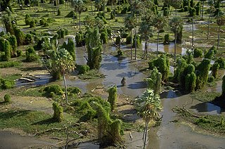
The Ciénegas del Lerma is a wetland in central Mexico. It consists of three lakes in the Toluca Valley, the upper basin of the Lerma River, near the city of Toluca. The wetlands cover 3,023 hectares.

Sacramento–San Joaquin is a freshwater ecoregion in California. It includes the Sacramento and San Joaquin river systems of California's Central Valley, which converge in the inland Sacramento–San Joaquin Delta. It also includes the mostly-closed Tulare Lake basin in the southern Central Valley, the rivers and streams that empty into San Francisco Bay, and the Pajaro and Salinas river systems of Central California which empty into Monterey Bay.

<span class="mw-page-title-main">Lake Yuriria</span> Reservoir in Guanajuato, Mexico

Lake Yuriria is a reservoir in Guanajuato state of central Mexico. The reservoir has existed since the 16th century, and is used for irrigation of the surrounding farms. The lake is an important habitat for waterbirds, and was declared a wetland of international importance.

References

  1. 1 2 3 4 5 6 7 8 9 "Central Mexican wetlands". Terrestrial Ecoregions. World Wildlife Fund.
  2. 1 2 "Ciénegas de Lerma". Ramsar Sites Information Service. Accessed 1 December 2020.
  3. 1 2 "Humedales del Lago de Pátzcuaro". Ramsar Sites Information Service. Accessed 1 December 2020.
  4. 1 2 "Sistema Lacustre Ejidos de Xochimilco y San Gregorio Atlapulco" Ramsar Sites Information Service. Accessed 2 December 2020.
  5. BirdLife International (2020) Endemic Bird Areas factsheet: Central Mexican marshes. Downloaded from http://www.birdlife.org on 01/12/2020.