Last updated • 11 min readFrom Wikipedia, The Free Encyclopedia
Park and market in Xochimilco, Mexico City, Mexico
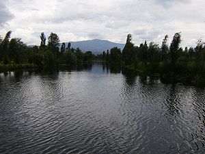
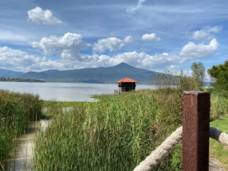
View from one of the canals in the park
Xochimilco Ecological Park and Plant Market is a natural reserve or park, with a 13-hectare (32-acre) plant market, the largest in Latin America. The park and market are located in the southern Mexico City borough of Xochimilco, about 23km south of the historic center of the city. The park was designed by Mario Schjetnan.[1] The park was inaugurated in 1993, on chinampas (artificial lake islands) which had been previously declared as part of a World Heritage Site. However, the area's ecology was badly degraded, and the park was established in order to revitalize and preserve the ecosystem. Success has been mixed. While much of the wetlands have been recharged, pollution and illegal settlements in the area remain as threats. As the park needs to be self-sustaining economically, there are a number of ways that the park raises money. One of the best known of these is the Xochimilco or Cuemanco Plant Market, which rents stalls to ornamental plant producers/sellers near the main entrance of the park.
Canal with chinampas on both sidesCows grazing on chinampas in the parkBoats called "trajineras" in a canal
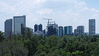
The park extends over 215 hectares (0.83sqmi) in the borough of Xochimilco, 23km south of the historic center of Mexico City, between the Calle de Miramontes and the headquarters of the Secretary of the Navy.[2] This area of Xochimilco is known as Cuemanco, so the park and market are also sometimes referred to with this name.[2][3] The population around the area is a mix of urban, semi-urban and rural settlements. No one is permitted to live in the park.[2] It is the largest park in Mexico City after Chapultepec,[3] and is considered to be one of the "lungs" of Mexico City.[4] The park is divided by the Anillo Periférico, with the section north of the road smaller than the southern section.[5]
The park has agreements with the public schools and receives 150,000 school children each year.[4]
Much of the park's territory is dedicated to chinampas. Chinampas are artificial islands created on the shallow waters of the lakes starting in the pre-Hispanic period. These islands began as rafts made with tree branches and other materials, which were then loaded with soil and mud from the lake bottom and tied to ahuejote or other kinds of trees to anchor them. Over time, these rafts would sink and pile up on the shallow lake bottom, eventually becoming fixed islands. As these islands multiplied in number, they became separated by canals, which are necessary to keep a constant supply of water to the chinampa. The canals of the parks were created by this method. In the past, chinampas were primarily used for the growing of foodstuffs, but today, most of what is raised is ornamental plants.[6] Much of the ecological system was restored over a five-year period, then the area opened as a park in 1993 in order to create tourism, hinder the urbanization of the area and preserve the local ecology.[2] Most of the park's area is an aquatic environment of lakes, canals or chinampas with some forested areas, much of which are planted with ahuejotes, pines and eucalyptus.[2] Most of these chinampas have been transformed into "agro-ecological" land, meaning it is an ecological preserve and farmland at the same time. This area extends from Cuemanco to Mixquic in the Tláhuac borough, all connected by a series of canals. These are what made Xochimilco a World Heritage Site.[7] The aim of this area is to preserve an environment known to the Aztecs over 500 years ago.[8][9]
In addition to the chinampas, restoration efforts expanded a lake to 54hectares and created two smaller artificial ones of about a hectare each. Facing these waterways is the Cuemanco embarcadero (docks) from which trajinera boats depart,[2] near the best-preserved chinampas in Xochimilco.[5] Trajineras are flat-bottomed barges similar to gondolas. These were used in the past to move merchandise around the vast lake and canal system of the Valley of Mexico. Today, most are used for tourism. Tourist trajineras have been somewhat modified from ancient ones with the addition of a roof for shade, tables and chairs for picnicking and a large brightly decorated arch, often with a woman's name over top.[6] In October and November, for Day of the Dead, the Cuemanco embarcadero hosts a play about La Llorona, a spectre said to roam parts of Mexico at night looking for her children. The play is called Cihuacóatl, Leyenda de la Llorona. This version of the story is based on an old goddess of the area called Cihuacóatl, whose story is similar to the current folk tale. Spectators are taken from the embarcadero to the Tlilac Lake on trajineras along canals with light and sound effects. The play takes place on a chinampa in the lake.[10] These boats, along with the associated plant market, are the best-known features of the park.[7]
The park is divided into four areas: recreational, the Xochilta Garden, the bird sanctuary, and the botanical garden.[11] The park has a number of other attractions. There are two greenhouses, bicycle and jogging paths, the Cuemanco canal for rowing, a small zoo, an aviary managed by SEDESOL, an area with archeological artifacts, enclosures for deer and coyotes in rehabilitation, playgrounds, 35 fields and courts for sports and areas for picnicking with palapas.[2][3][9] The park's information center has displays related to the flora and fauna of the area.[5] Although the park is owned by the city, it is managed by a private civil association called the Patronato del Parque Ecológico de Xochimilco Asociación Civil, with the aim of making the park self-sustaining economically. There is an entrance fee of twenty pesos, and bicycles, ATVs and boats available to rent.[12] The plant market is also part of this, as stalls are rented out to sellers.[2][13]
One of the park's functions is to provide shelter for wildlife. The most iconic species to Xochimilco is the axolotl, a salamander species considered to be an incarnation of a god by the Aztecs because of its ability to regrow certain body parts. This animal is highly endangered and is no longer found wild in the canals of Xochimilco. It is kept from extinction through the efforts of organizations such as Umbral Axochiatl, which works in conjunction with the Instituto de Biología de la Universidad Nacional Autónoma de México (UNAM). These have facilities at the park.[7] Other research facilities include a meteorology station and a laboratory to test the soil and water.[4]
Wading egret in the park
More successful has been the preservation of areas to host bird species, both those that live in the area year-round and those who migrate here in the winter.[3] Many are seen on the large lake, called Huetzalen.[14] The waters contain reeds, another plant called chacatules,[check spelling] often used in crafts, aquatic birds, insects and fish. The area is very quiet, especially compared to the urban area which nearly surrounds it.[12] Migratory birds can be seen in the area starting in October,[12] but the best time to see them is between December and April.[14] Registered birds include sparrows, grackles, storks, hummingbirds, eagles, herons, moorhens and egrets.[5] There are 15 species of ducks both native and migratory.[14]
Another migratory bird seen in the winter is the great egret, which grows to up to a meter in height. Some rare birds that have been seen here include the common kestrel, the osprey and certain types of owl. The most commonly observed migratory species is the American white pelican, which was not seen in the area before the lake and canals were restored.[14] However, this species has only been seen in numbers since the 2000s, with 500 reported as of 2009.[7][12] These birds migrate here from Canada and the northern US.[15] Another important species is the kingfisher, which was earlier thought to be extinct in the area, but has been seen again.[14]
One drawback of the park is its lack of mature shade trees, as they were planted when the park was founded in the 1990s.[5] The park's ecology remains in danger from pollution associated with urban sprawl. The water is contaminated by sewage and household garbage, damaging flora, driving away wildlife and risking the health of surrounding residents.[2]
The Cuemanco Plant Market
The Xochimilco Plant Market, also called the Cuemanco Market, sits on an extension of 13 hectares of park land near the main entrance on Canal Nacional, where it crosses the Anillo Períferico Oriente.[3][16] This live plant market and warehouse is the largest of its type in Latin America.[16][17] It is the main moneymaking operation of the ecological park, renting out 1,700 stalls to sellers of live plants and related items, much the same way as Mexican traditional markets. Most of the sellers are producers.[13][17] However, only about 600 stalls are active selling points, the rest are empty or used for storage.[13]
The most important related products made and sold at the market are flowerpots and vases. As the growing of ornamental plants is a relatively new phenomenon for Xochimilco, so is the making of these wares. Many craftsmen taught themselves how to create them. Most are made from traditional ceramics, but some are made with other materials, including recycled ones. Most are made by the sellers themselves and painted in bright colors and/or decorated with pebbles, crystals and other items.[16]
In addition to the plant-vending areas, there is a cactus garden and areas with restaurants.[3] The market has at least seven stands that serve beer without the necessary permits and have been accused of selling to underage students from the three universities and prepas near the area – UAM Xochimilco, ITESM-CCM and Colegio de Bachilleres#4. A number attract student patrons by playing popular music on large loudspeakers. These stands are particularly popular with students on Fridays.[18]
Although the installation of the market and other moneymaking operations have proven to be successful,[12] this plant market did have financial and operating difficulties in 2001. The financial difficulties were associated with losses in the funds destined for improvements and repairs. One reason for this was that many of the stalls had not yet been rented.[13] Another problem was ongoing disputes between plant sellers and the then manager of the market, which required intervention by borough authorities.[19] This market is the largest in Xochimilco but there are several others in the borough also dedicated to plants. These include Madreselva in the Bosque de Nativitas, Mercado Xochimilco, the Palacio de la Flor and the historic market of the San Luis Tlaxialtemalco community.[16][17]
History
Much of the area of the park has been chinampa land since the pre-Hispanic period. Xochimilco is one of few areas left in the Valley of Mexico that still has a significant number of chinampas. The area was declared a biological reserve by the Mexican government in 1984 and a World Heritage Site in 1987 by UNESCO.[2][12]
Until 1988, the park land had been privately owned. However, the area had been severely degraded with lakes and canals going dry and the salinity and pollution of the remaining water making farming nearly impossible. The pollution was primarily coming from the Buenaventura River, with carried with it dirty water from other rivers in the south of the city. By the 1980s, these chinampa farmers had been prohibited from growing any edible plants on their lands.[4][12]
The city and federal governments conceived and began to implement a plan to save Mexico City's remaining chinampas called the Xochimilco Ecological Rescue Plan (Plan de Rescate Ecológico de Xochimilco), the center of which was the establishment of the park.[8] The goal the project is to restore the chinampa ecosystem here to what it was during the Aztec Empire and then preserve it that way. The area was recharged with treated water to reinvigorate and create much of the surface water that is there today. Native vegetation was brought in by biologists and botanists. To restore soils, much of the sanitary debris from the 1985 earthquake and soils dug from the building of the Metro was brought in.[12]
After five years of work, the park was opened to the public in 1993.[12] Eight years after its establishment, it already had 240,000 trees and 500,000 other kinds of plants over 210 hectares.[4] However, expropriation of the land was fought by the chinampa owners for years after it occurred.[4] The most problematic time for the park was in 2001, eight years after its opening. Despite major investments and efforts into restoration, there were still very serious contamination problems and a number of ejido lands that had been appropriated in the 1980s were given back to owners by the courts. The setback caused a number of local organizations to denounce the project as a failure and demand that then Mexico City mayor Andrés Manuel López Obrador investigate.[20]
Since then, the park has managed to survive and be self-sustaining.[12] However, serious environmental problems continue to plague that park and the rest of chinampa lands in Xochimilco. Pollution of the waters in the lakes and canals continue to be serious, as sewage and household garbage finds its way into the water.[2] However, the most pressing problem is invasions of chinampa land by illegal settlements. In 2004 and 2007, families who had been swindled into illegally buying lands in the park lost their homes as they were evicted.[21][22] Many people living illegally on the land have organized to put political pressure on authorities to let them remain, with mixed success.[22][23] The fact that there are still illegal settlements in the park, which is land designated as a World Heritage Site, has put the borough at odds with UNESCO. UNESCO wants all illegal settlements out in order to preserve the site's status, but borough officials claim this would not be feasible.[23][24]
Chinampa is a technique used in Mesoamerican agriculture which relies on small, rectangular areas of fertile arable land to grow crops on the shallow lake beds in the Valley of Mexico. They are built up on wetlands of a lake or freshwater swamp for agricultural purposes, and their proportions ensure optimal moisture retention. The United Nations designated it a Globally Important Agricultural Heritage System in 2018.
Iztacalco is a borough in Mexico City. It is located in the central-eastern area and it is the smallest of the city's boroughs. The area's history began in 1309 when the island of Iztacalco, in what was Lake Texcoco, was settled in 1309 by the Mexica who would later found Tenochtitlan, according to the Codex Xolotl. The island community would remain small and isolated through the colonial period, but drainage projects in the Valley of Mexico dried up the lake around it. The area was transformed into a maze of small communities, artificial islands called chinampas and solid farmland divided by canals up until the first half of the 20th century. Politically, the area has been reorganized several times, being first incorporated in 1862 and the modern borough coming into existence in 1929. Today, all of the canals and farmland are dried out and urbanized as the most densely populated borough and the second most industrialized.
Miguel Hidalgo is a borough (alcaldía) in western Mexico City, it encompasses the historic areas of Tacuba, Chapultepec and Tacubaya along with a number of notable neighborhoods such as Polanco and Lomas de Chapultepec. With landmarks such as Chapultepec Park and the Museo Nacional de Antropología, it is the second most visited borough in Mexico City after Cuauhtémoc where the historic center of Mexico City is located. Tacubaya and Tacuba both have long histories as independent settlements and were designated as “Barrios Mágicos” by the city for tourism purposes.
Venustiano Carranza is a borough in Mexico City, Mexico. Venustiano Carranza extends from the far eastern portion of the historic center of Mexico City eastward to the Peñón de los Baños and the border dividing the then Federal District from the State of Mexico. Historically, most of the territory was under Lake Texcoco, but over the colonial period into the 20th century, the lake dried up and today the area is completely urbanized. The borough is home to three of Mexico City's major traditional markets, including La Merced, the National Archives of Mexico, the Palacio Legislativo de San Lázaro, the TAPO intercity bus terminal and the Mexico City Airport.
Iztapalapa is a borough in Mexico City, located on the east side of the entity. The borough is named after and centered on the formerly independent municipality of Iztapalapa, which is officially called Iztapalapa de Cuitláhuac for disambiguation purposes. The rest is made up of a number of other communities which are governed by the city of Iztapalapa.
Tlalpan is a borough in Mexico City. It is the largest borough, with over eighty percent under conservation as forest and other ecologically sensitive area. The rest, almost all of it on the northern edge, has been urban since the mid-20th century. When it was created in 1928, it was named after the most important settlement of the area, Tlalpan, which is referred to as “Tlalpan center” to distinguish it from the borough.
Xochimilco is a borough of Mexico City. The borough is centered on the formerly independent city of Xochimilco, which was established on what was the southern shore of Lake Xochimilco in the precolonial period.
Tláhuac is a borough in the Mexico City, located in the southeastern edge of the entity. Though Tláhuac still contains rural communities within its borders, mostly in the southern and eastern portions, the borough has undergone a massive shift from urbanization, especially in its northwest. Tláhuac has experienced the fastest rate of population growth in Mexico City since the 1960s.
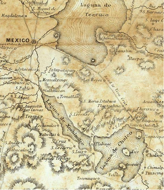
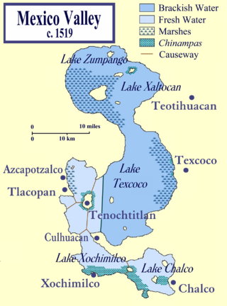
Lake Texcoco was a natural lake within the Anahuac or Valley of Mexico. Lake Texcoco is best known for an island situated on the western side of the lake where the Mexica built the city of Mēxihco Tenōchtitlan, which would later become the capital of the Aztec Empire. After the Spanish conquest, efforts to control flooding led to most of the lake being drained.
Lake Xochimilco is an ancient endorheic lake, located in the present-day Borough of Xochimilco in southern Mexico City. It is the last remaining habitat of the axolotl.
Cuahilama is a Hill and an archaeological site located south east of Santa Cruz Acalpixca, in the Cuahilama neighborhood, near the Xochimilco Archaeological Museum, in Mexico City. It was a ceremonial center, in the hill are prehispanic images engraved in basaltic rock.
The Central de Abasto is Mexico City's main wholesale market for produce and other foodstuffs run similarly to traditional public markets. It was constructed to be the meeting point for producers, wholesalers, retailers and consumers for the entire country. Located in the eastern borough of Iztapalapa, it is the most important commercial establishment in Mexico and the largest of its kind in the world. The market handles over 30,000 tons of merchandise daily, representing 80% of the consumption of the Mexico City metropolitan area. The market was established on former farmland to ease congestion in the historic center of Mexico City.
La Nueva Viga Market is the largest seafood market in Mexico and the second largest in the world after the Toyosu Market in Japan. It is located in Mexico City far inland from the coast, because of historical patterns of commerce in the country. The market handles 1,500 tons of seafood daily, representing about 60% of the total market. Most of the seafood is distributed to the Mexico City metropolitan area and the states surrounding it, but there is distribution to other states and abroad.
Mercado Jamaica is one of Mexico City’s traditional public markets where various vendors sell their wares in an established location. This market began in the 1950s as part of efforts to urbanize the markets in the area. The market is located on the corner of Congreso de la Union and Avenida Morelos, just southeast of the Historic center of Mexico City. Although it is one of the main markets for souvenirs, produce and meat, it is best known for its flowers and ornamental plants. There are 1,150 stands dedicated to the selling of cut flowers, flower arrangements, ornamental plants and accessories such as flowerpots. The market offers about 5,000 types of flowers and plants, mostly foreign, but there is a number of native Mexican species available, including some gathered directly from the wild.
Xochimilco was the most important city of the Xochimilca people, one of the Nahua tribes that migrated to the Mesoamerica region. At the same time it was the name of the altepetl of this group and historically referred to both interchangebly. The city was founded around 900 AD. It grew to become an important city in the Valley of Mexico, until in 1430, the Mexica of Tenochtitlan succeeded in conquering the city.
Pueblo Culhuacán is an officially designated neighborhood of the Iztapalapa borough of Mexico City, which used to be a major pre-Hispanic city. Ancient Culhuacán was founded around 600 CE and the site has been continuously occupied since. The city was conquered by the Aztecs in the 15th century, but the Aztecs considered the city to have status with early rulers marrying into Culhua nobility to legitimize themselves. After the Spanish conquest of the Aztec Empire, the Franciscans and later the Augustinians made Culhuacán a major evangelization center, with the latter building the monastery complex which remains to this day. Today, Culhucan is fully integrated into Mexico City physically and politically. This area was designated as a "Barrio Mágico" by the city in 2011.
The Island of the Dolls is a chinampa of the Laguna de Tequila located in the channels of Xochimilco, south of the center of Mexico City, Mexico. It is notable for the number of dolls of various styles and colors that can be found throughout the island. Local legends surround the dolls and the island's reclusive former owner, Don Julián Santana Barrera, making the island a popular destination for dark tourism.
The Central Mexican wetlands is a flooded grasslands and savannas ecoregion in central Mexico.
Bicentennial Park is a park in Mexico City. It is located in the western part of the city, on the boundary of Azcapotzalco and Miguel Hidalgo. It was built as part of the Celebration of the Bicentennial of the Independence of Mexico and inaugurated by then President Felipe Calderón on November 7, 2010. This park is ten times larger than the Plaza de la Constitución in downtown Mexico City and the second largest "lung" in the city.
1 2 3 4 5 6 Jiménez González, Victor Manuel (2009). Ciudad de México: Guía para descubrir los encantos de la Ciudad de México[Mexico City: Guide to discover the charms of Mexico City] (in Spanish). Mexico City: Editorial Océano, S.L. p.55 and 57. ISBN978-607-400-061-0.
1 2 3 4 Alberto Gonzalez (July 9, 2001). "Aclararan el faltante en el mercado de flores" [Clarify the lacking funds at the flower market]. Reforma (in Spanish). Mexico City. p.8.
1 2 3 4 5 Edgar Anaya. (March 6, 2005). "Observan aves en el DF" [Observing birds in the Federal District]. El Norte (in Spanish). Monterrey, Mexico. p.11.
↑ "'Acampan' pelícanos en Cuemanco" [Pelicans "camp" in Cuemanco]. Reforma (in Spanish). Mexico City. February 21, 2010. p.1.
↑ Jesus Alberto Hernandez. (May 25, 2003). "Convierten mercado de flores en un bar" [Converting the flower market into a bar]. Reforma (in Spanish). Mexico City. p.1.
↑ Anibal Santiago. (June 17, 2001). "Analizan remocion en Mercado de Cuemanco" [Analyzing removal at the Cuemanco Market]. Reforma (in Spanish). Mexico City. p.4.
↑ Ivan Sosa. (January 19, 2001). "Consideran un fracaso el rescate ecologico" [Consider the ecological rescue a failure]. Reforma (in Spanish). Mexico City. p.1.
↑ Luis Pérez (May 19, 2004). "Recuperan reserva ecológica en Xochimilco"[Ecological reserve in Xochimilco recovered]. Noticieros Televisa (in Spanish). Mexico City. Archived from the original on July 10, 2011. Retrieved March 16, 2011.
1 2 Sosa, Ivan (November 20, 2004). "Exige la UNESCO blindar Xochimilco" [UNESCO demands the protection of Xochimilco]. Reforma (in Spanish). Mexico City. p.3.
↑ Cevallos, Diego (November 30, 2004). "Archeology: Mexico's 'Venice' imperiled by pollution and erosion". Global Information Network. New York. p.1.
This page is based on this Wikipedia article Text is available under the CC BY-SA 4.0 license; additional terms may apply. Images, videos and audio are available under their respective licenses.