
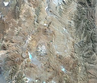
Aracar is a large conical stratovolcano in northwestern Argentina, just east of the Chilean border. It has a main summit crater about 1–1.5 kilometres (0.6–0.9 mi) in diameter which sometimes contains crater lakes, and a secondary crater. The volcano has formed, starting during the Pliocene, on top of a lava platform and an older basement. Constructed on a base with an altitude of 4,100 metres (13,500 ft), it covers a surface area of 192.4 square kilometres (74.3 sq mi) and has a volume of 148 cubic kilometres (36 cu mi). The only observed volcanic activity was a possible steam or ash plume on March 28, 1993, seen from the village of Tolar Grande about 50 km (31 mi) southeast of the volcano, but with no evidence of deformation of the volcano from satellite observations. Inca archeological sites are found on the volcano.

Incahuasi is a volcanic mountain in the Andes of South America. It lies on the border of the Catamarca Province of Argentina and the Atacama Region of Chile. Incahuasi has a summit elevation of 6,621 metres (21,722 ft) above sea level.
Cerro Galán is a caldera in the Catamarca Province of Argentina. It is one of the largest exposed calderas in the world and forms part of the Central Volcanic Zone of the Andes, one of the three volcanic belts found in South America. One of several major caldera systems in the Central Volcanic Zone, the mountain is grouped into the Altiplano–Puna volcanic complex.

Aucanquilcha is a massive stratovolcano located in the Antofagasta Region of northern Chile, just west of the border with Bolivia and within the Alto Loa National Reserve. Part of the Central Volcanic Zone of the Andes, the stratovolcano has the form of a ridge with a maximum height of 6,176 metres (20,262 ft). The volcano is embedded in a larger cluster of volcanoes known as the Aucanquilcha cluster. This cluster of volcanoes was formed in stages over eleven million years of activity with varying magma output, including lava domes and lava flows. Aucanquilcha volcano proper is formed from four units that erupted between 1.04–0.23 million years ago. During the ice ages, both the principal Aucanquilcha complex and the other volcanoes of the cluster were subject to glaciation, resulting in the formation of moraines and cirques.

The Purico complex is a Pleistocene volcanic complex in Chile close to Bolivia, formed by an ignimbrite, several lava domes and stratovolcanoes and one maar. It is in the Chilean segment of the Central Volcanic Zone, one of the four volcanic belts which make up the Andean Volcanic Belt. The Central Volcanic Zone spans Peru, Bolivia, Chile and Argentina and includes 44 active volcanoes as well as the Altiplano–Puna volcanic complex, a system of large calderas and ignimbrites of which Purico is a member. Licancabur to the north, La Pacana southeast and Guayaques to the east are separate volcanic systems.

Los Flamencos National Reserve is a nature reserve located in the commune of San Pedro de Atacama, Antofagasta Region of northern Chile. The reserve covers a total area of 740 square kilometres (290 sq mi) in the Central Andean dry puna ecoregion and consists of seven separate sections.
Chiliques is a stratovolcano located in the Antofagasta Region of Chile.

Pular is a massive stratovolcano located in the Antofagasta Region of northern Chile, about 15 km west of the border with Argentina, which in this area is a straight line between the summits of Socompa volcano and Cerro del Rincón. Pular, along with Cerro Pajonales, forms a high volcanic ridge, which runs in a generally north-east to south-west direction for 12 km (7 mi). Southward, following the same direction as the ridge, lies Socompa volcano. The ridge's crest forms a drainage divide between Salar de Atacama basin and Salar de Pular basin. This latter is a bowl-shaped basin enclosed on the east by Aracar volcano.
Cerro del Azufre is a stratovolcano located in El Loa Province, Antofagasta Region, Chile. It is part of a chain of volcanoes that separate Upper Loa River basin from Salar de Ascotán basin and is flanked to the west by a dacitic lava dome called Chanka or Pabellón. The 6000 metre volcanoes San Pedro and San Pablo are located to the southwest of Cerro del Azufre.

La Pacana is a Miocene age caldera in northern Chile's Antofagasta Region. Part of the Central Volcanic Zone of the Andes, it is part of the Altiplano-Puna volcanic complex, a major caldera and silicic ignimbrite volcanic field. This volcanic field is located in remote regions at the Zapaleri tripoint between Chile, Bolivia and Argentina.

Salar de Ascotán, also known as Salar de Cebollar, is a salt flat in northern Chile. Its drainage basin is 1,455 square kilometers (562 sq mi) and is shared with Bolivia. The basin is bordered on the north by the Salar de Carcote basin, on the east by small endorheic basins, including those of Laguna Cañapa and Laguna Hedionda, from which is separated by the crest of the Cerros de Cañapa, Cerro Araral and others. To the south, the basin is bordered by the San Pedro de Inacaliri River basin, while to the west the drainage divide between the salt flat and the Upper Loa River basin is marked by the summits of a chain of volcanoes culminating in Palpana.

Tunupa is a dormant volcano in the Potosí Department of southwestern Bolivia.

Tuyajto Lake is a salt lake located in the Antofagasta Region, northern Chile. Located at an elevation of about 4,010 metres (13,160 ft), its surface area presently fluctuates between 1.7–2.7 square kilometres (0.66–1.04 sq mi) but in the past it was considerably larger; this led to humans going to the lake and creating archeological sites there. Presently, the lake is groundwater-fed and has no surface outlet but water might seep out underground. It is part of the Los Flamencos Natural Reserve.

Tittivilla is an eroded volcano in the Andes of Bolivia, on the isthmus separating the Salar de Coipasa in the north from the Salar de Uyuni. The maximum slope in its summit area is 30°. The stratovolcano and neighbouring Tunupa formed 3.5-2.5 mya on NE-SW and NNE-SSW structures, it belongs to the Tungapujo-Guachacoyo volcanic chain. The volcanoes are formed from andesite and dacite belonging to potassium-rich calc-alkaline series.

Corrida de Cori is a mountain range in Argentina and Chile. It consists of several aligned volcanoes, including Cerro Escorial, which exceed 5 kilometres (3.1 mi) in elevation. The range, together with several local volcanoes, forms an alignment that may be controlled by a fault system. The volcanoes erupted mainly andesite and basaltic andesite, they were active in the Plio-Pleistocene with the most recent activity occurring at Cerro Escorial and at a cinder cone east of the range. There are two mines in the area, with a weather station nearby.

Sairecabur is a volcano located on the frontier between Bolivia and Chile. It is part of the Andean Central Volcanic Zone. Sairecabur proper is 5,971 m (19,590 ft) high; other mountains in the range are 5,722 m (18,773 ft) high Curiquinca, 5,819 m (19,091 ft) high Escalante and 5,748 m (18,858 ft) high Cerro Colorado, all of which have erupted a number of lava flows. Also in close proximity to Sairecabur lie the volcanic centres Licancabur, Putana and Juriques.
Llullaillaco is a dormant stratovolcano at the border of Argentina and Chile. It lies in the Puna de Atacama, a region of tall volcanic peaks on a high plateau close to the Atacama Desert, one of the driest places in the world. It is the second highest active volcano in the world after Ojos del Salado.

Olca-Paruma is a volcanic complex in Chile. Lying on the border between Chile and Bolivia, it is formed by an east–west alignment of volcanoes. From west to east, these are Cerro Paruma, Volcan Paruma, Olca, and Mencheca or Michincha. Aside from the mines of Ujina, Rosario, and Quebrada Blanca, the area is sparsely populated.

Sillajhuay is a volcano on the border between Bolivia and Chile. It is part of a volcanic chain that stretches across the border between Bolivia and Chile and forms a mountain massif that is in part covered by ice; whether this ice should be considered a glacier is debatable but it has been retreating in recent decades.

Salar Ignorado is a salar in the Andes of Chile's Atacama Region at 4,250 metres (13,940 ft) elevation. Located just south of Cerro Bayo volcano, it comprises 0.7 square kilometres (0.27 sq mi) of salt flats, sand dunes and numerous pools of open water. The waters of Salar Ignorado, unlike these of other salt flats in the central Andes, are acidic owing to the input of sulfuric acid from hydrothermal water and the weathering of volcanic rocks.
