

Chadlington Road is a road in North Oxford, England. [1]
Chadlington Road is a road in North Oxford, England. [1]
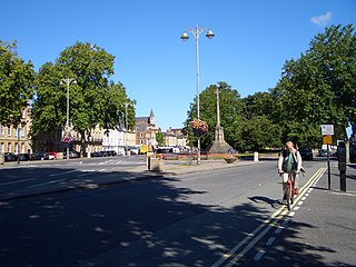
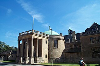
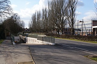
At the northern end is Linton Road, close to the front entrance of Wolfson College, a graduate college of the University of Oxford. Many of the houses on the east side adjoin and are used by the college. At the southern end, the road continues as Bardwell Road by the Dragon School. Here a small lane leads east down to the Cherwell Boathouse (formerly "Tims's") on the River Cherwell, where punts can be hired and a restaurant is now located. Parallel to the west is Charlbury Road.
Houses in the road were first leased between 1910 and 1917. [1] Most of the houses were designed by the architect N. W. Harrison. No. 11 was designed with half-timbering and stone-battered buttresses by Frank Mountain. [2]
William Henry Perkin, Jr. (1860–1929), an organic chemist at the University of Oxford and the son of the notable chemist W. H. Perkin, leased No. 3 Chadlington Road in 1917. [1]
The historian and author Antonia Fraser (born 1932) lived at 8 Chadlington Road as a child when she attended the Dragon School, a short walking distance away. [3]
J. H. R. ('Joc') Lynam, headmaster of the Dragon School from 1942–65, leased 6 Chadlington Road in 1958. [4]
The Haldane family [5] lived at 'Cherwell', a house located between Chadlington Road and the River Cherwell, in the early 20th century. The family included the physiologist and father, John Scott Haldane, together with his children, the geneticist and evolutionary biologist, J. B. S. Haldane (Fellow of New College, Oxford), and the novelist Naomi Mitchison. The house was built by George Gardiner and included a private laboratory. It was demolished to make way for Wolfson College, completed in 1974.

Oxfordshire is a ceremonial county in South East England. The county is bordered by Northamptonshire and Warwickshire to the north, Buckinghamshire to the east, Berkshire to the south, and Wiltshire and Gloucestershire to the west. The city of Oxford is the largest settlement and county town.

Wolfson College is a constituent college of the University of Oxford in England. Located in north Oxford along the River Cherwell, Wolfson is an all-graduate college with around sixty governing body fellows, in addition to both research and junior research fellows. It caters to a wide range of subjects, from the humanities to the social and natural sciences. Like the majority of Oxford's newer colleges, it has been coeducational since its foundation in 1965.
The Dragon School is one school on two sites in Oxford, England. The Dragon Pre-Prep and Prep School are both co-educational schools. The Dragon Prep School was founded in 1877 as the Oxford Preparatory School. It takes day pupils and boarders.

The River Cherwell is a tributary of the River Thames in central England. It rises near Hellidon, Northamptonshire and flows southwards for 40 miles (64 km) to meet the Thames at Oxford in Oxfordshire.

North Oxford is a suburban part of the city of Oxford in England. It was owned for many centuries largely by St John's College, Oxford and many of the area's Victorian houses were initially sold on leasehold by the college.

Summertown in North Oxford is a suburb of Oxford, England. Summertown is a one-mile square residential area, north of St Giles, the boulevard leading out of Oxford's city centre. Summertown is home to several independent schools and the city's most expensive houses. On both sides of Banbury Road are Summertown's popular shops. There is also a smaller street of shops and restaurants, South Parade, that links Banbury Road and Woodstock Road. Summertown is home to much of Oxford's broadcast media. BBC Radio Oxford and the BBC Television's Oxford studios are on Banbury Road. Start-ups also have an increasing presence on the parade, such as Brainomix and Passle. The studios for JACK FM, Glide FM, and Six TV Oxford are on Woodstock Road.
St Giles' is a wide boulevard leading north from the centre of Oxford, England. At its northern end, the road divides into Woodstock Road to the left and Banbury Road to the right, both major roads through North Oxford. At the southern end, the road continues as Magdalen Street at the junction with Beaumont Street to the west. Also to the west halfway along the street is Pusey Street. Like the rest of North Oxford, much of St Giles' is owned by St John's College.
South Parks Road is a road in Oxford, England. It runs east–west past the main Science Area of the University of Oxford. Many of the university science departments are located nearby or face the road, including parts of the geography, zoology, chemistry, psychology and physiology departments. Also on the road is Rhodes House.
Marston Ferry Road is a link road in north Oxford, England. It is named after the ferry that used to cross the River Cherwell at the village of Marston from at least 1279.

Bardwell Road is a residential road in Oxford, England. It is located in North Oxford off the Banbury Road, within the area of Oxford once owned by St John's College, Oxford. The road is known for its schools, especially the Dragon School.

The Cherwell Boathouse is a boathouse and restaurant on the River Cherwell in Oxford, England. It is located down a small lane off the junction between Chadlington Road and Bardwell Road, which itself is off the Banbury Road in North Oxford.

Linton Road is a road in North Oxford, England.

Norham Gardens is a residential road in central North Oxford, England. It adjoins the north end of Parks Road near the junction with Banbury Road, directly opposite St Anne's College. From here it skirts the north side of the Oxford University Parks, ending up at Lady Margaret Hall, a college of Oxford University that was formerly for women only, backing onto the River Cherwell. Public access to the Parks is available from the two ends of the road. To the north of the road are Bradmore Road near the western end and Fyfield Road near the eastern end.

The Norham Manor estate is a residential suburb in Oxford, England. It is part of central North Oxford. To the north is Park Town with its crescents, to the east is the River Cherwell, to the south are the University Parks and to the west is Walton Manor, on the other side of Banbury Road.

Milham Ford School was a girls' secondary school in Oxford, England, located in the suburb of New Marston on Marston Road. It was founded in East Oxford in the 1880s and closed in 2003.

Norham Road is a road which lies east of the Banbury Road in central North Oxford, a suburb in the city of Oxford, England.
Garford Road is a residential road in North Oxford, England.

Crick Road is a road in North Oxford, England, an area characterised by large Victorian Gothic villas.

The Victoria Arms is a pub on the eastern bank of the River Cherwell at the end of Mill Lane close to Old Marston, northeast of Oxford, England.
Nathaniel William Harrison was an English architect.
51°46′12″N1°15′23″W / 51.7700°N 1.2563°W
| | This Oxfordshire location article is a stub. You can help Wikipedia by expanding it. |
| | This England road or road transport-related article is a stub. You can help Wikipedia by expanding it. |