


Linton Road is a road in North Oxford, England. [2]
Linton Road is a road in North Oxford, England. [2]
At the western end is the Banbury Road. At the eastern end is Wolfson College, a graduate college of the University of Oxford. To the north at the eastern end, Garford Road runs parallel with Linton Road. The road also adjoins Northmoor Road, Charlbury Road and Chadlington Road.
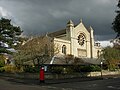
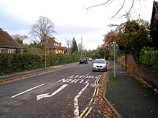
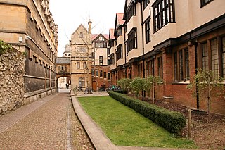
Linton Lodge Hotel [1] is located in this road, as well as the Parklands Hotel on the corner of Banbury Road and Linton Road. The Bishop of Oxford also had a house here, near the western end, until its owners, Wolfson, reclaimed it in late 2014. [3] St Andrew's Church [4] is on the southeast corner of the junction with Northmoor Road. The road has speed humps to prevent traffic from moving too quickly.
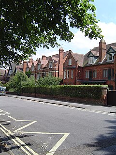
Houses in the road were first leased between 1895 and 1925. [2] Architects include J. C. Gray, N. W. Harrison, E. J. Marriott, Arthur C. Martin, A. H. Moberly (who also worked with William Crabtree on the Peter Jones department store in London [5] ), and Harry Wilkinson Moore. Of special architectural interest, as noted by Pevsner, is No. 7 Linton Road, on the northwest corner of the junction with Northmoor Road, designed by A. H. Moberly in 1903. [6]
On 4 May 1941 during World War II, an Armstrong Whitworth Whitley bomber of the Royal Air Force, based at RAF Abingdon, crashed at the eastern end of Linton Road on the site of what is now Wolfson College. [7] The crew and one civilian were killed, and two further people on the ground were injured.
The Haldane family [8] lived at 'Cherwell', a house located at the eastern end of Linton Road, in the early 20th century, having previously lived at 11 Crick Road. [9] The family included the physiologist and father, John Scott Haldane, together with his children, the geneticist and evolutionary biologist, J. B. S. Haldane (Fellow of New College, Oxford), and the novelist Naomi Mitchison. The house was built by George Gardiner and included a private laboratory. It was demolished to make way for Wolfson College, located next to the River Cherwell. The College was designed by the Powell and Moya Architects, and completed in 1974.
Other former residents include the physical chemist Sir Harold Warris Thompson (1908–1983), at No. 33, [10] and historian Michael Brock (1920–2014) with his wife (and co-editor) Eleanor. [11]


Steeple Aston is a village and civil parish on the edge of the Cherwell Valley, in the Cherwell District of Oxfordshire, England, about 12 miles (19 km) north of Oxford, 7 miles (11 km) west of Bicester, and 10 miles (16 km) south of Banbury. The 2011 Census recorded the parish population as 947. The village is 108 metres (354 ft) above sea level. The River Cherwell and Oxford Canal pass 1 mile (2 km) east of the village. The river forms part of the eastern boundary of the parish. The parish's southern boundary, 1⁄2 mile (800 m) south of the village, also forms part of Cherwell District's boundary with West Oxfordshire.

North Oxford is a suburban part of the city of Oxford in England. It was owned for many centuries largely by St John's College, Oxford and many of the area's Victorian houses were initially sold on leasehold by the College.

Bodicote is a village and civil parish about 2 miles (3 km) south of the centre of Banbury in Oxfordshire. The 2011 Census recorded the parish's population as 2,126.

Summertown in North Oxford is a suburb of Oxford, England. Summertown is a one-mile square residential area, north of St Giles, the boulevard leading out of Oxford's city centre. Summertown is home to several independent schools and the city's most expensive houses. On both sides of Banbury Road are Summertown's popular shops. There is also a smaller street of shops and restaurants, South Parade, that links Banbury Road and Woodstock Road. Summertown is home to much of Oxford's broadcast media. BBC Radio Oxford and the BBC Television's Oxford studios are on Banbury Road. Start-ups also have an increasing presence on the parade, such as Brainomix and Passle. The studios for JACK FM, Glide FM, and Six TV Oxford are on Woodstock Road.
Belbroughton Road is a residential road in the suburb of North Oxford, England. The road runs east from Banbury Road. At the other end is Oxford High School, a girls' school. South from the road about halfway along is Northmoor Road, where J. R. R. Tolkien lived for a while in the 1930s. At the eastern end is Charlbury Road.
Keble Road is a short road running east–west in central Oxford, England. To the west is the southern end of the Banbury Road with St Giles' Church opposite. To the east is Parks Road with the University Parks opposite. Blackhall Road leads off the road to the south near the western end.
Bardwell Road is a road in North Oxford, England, off the Banbury Road.

Northmoor Road is a residential street in North Oxford, England.

Bevington Road is a residential road in central North Oxford, England.

Norham Gardens is a residential road in central North Oxford, England. It adjoins the north end of Parks Road near the junction with Banbury Road, directly opposite St Anne's College. From here it skirts the north side of the Oxford University Parks, ending up at Lady Margaret Hall, a college of Oxford University that was formerly for women only, backing onto the River Cherwell. Public access to the Parks is available from the two ends of the road. To the north of the road are Bradmore Road near the western end and Fyfield Road near the eastern end.

St Margaret's Road is a road in North Oxford, England.

Charlbury Road is a road in North Oxford, England, running to the east of and parallel with the Banbury Road.

The Norham Manor estate is a residential suburb in Oxford, England. It is part of central North Oxford. To the north is Park Town with its crescents, to the east is the River Cherwell, to the south are the University Parks and to the west is Walton Manor, on the other side of Banbury Road.
Harry Wilkinson Moore, FRIBA (1850–1915) was a Victorian and Edwardian architect. He was the son of Arthur Moore (1814–1873) and Mary Wilkinson (1821–1904), and a nephew of the architects George Wilkinson and William Wilkinson.

Chadlington Road is a road in North Oxford, England.

Rawlinson Road is a residential road in North Oxford, England.

St Andrew's Church, Oxford is an evangelical Church of England parish church in Oxford, England. It was consecrated in 1907 and is located on the southeast corner of Linton Road and Northmoor Road in the suburb of North Oxford.

New Road is a street in west central Oxford, England. It links Park End Street and Worcester Street to the west with Queen Street and Castle Street to the east. To the south is Oxford Castle and the former Oxford Prison, now a Malmaison hotel. To the north is Nuffield College, a graduate college of Oxford University. At the eastern end on the south side is New County Hall, the headquarters of Oxfordshire County Council.
Bradmore Road is a residential road in North Oxford, England.

Crick Road is a road in North Oxford, England, an area characterised by large Victorian Gothic villas.