
Hugli-Chuchura or Hooghly-Chinsurah is a city and a municipality of Hooghly district in the Indian state of West Bengal. It lies on the bank of Hooghly River, 35 km north of Kolkata. It is located in the district of Hooghly and is home to the district headquarters. Chuchura houses the Commissioner of the Burdwan Range. It is a part of the area covered by Kolkata Metropolitan Development Authority (KMDA). The District Court building of Chinsurah is the longest building in West Bengal.

Khardaha is a city and a municipality of North 24 Parganas district in the Indian state of West Bengal. It is close to Kolkata and also a part of the area covered by Kolkata Metropolitan Development Authority (KMDA).
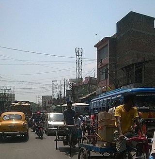
Habra is a city and a municipality under Barasat sadar subdivision in North 24 Parganas district of the Indian state of West Bengal. It is situated on the Jessore Road between Kolkata and the Bangladesh border at Petrapole. Its location makes it an important town for export and import of goods between India and Bangladesh.

Malbazar, also known as Mal, is a town and a municipality in Jalpaiguri district in the state of West Bengal, India. It is the headquarters of the Malbazar subdivision. It lies about 65 km from Jalpaiguri and 55 km from Siliguri. It lies on the bank of river Neora.
Adampur is a town, a municipal council and a sub-tehsil in Jalandhar district in the Indian state of Punjab.
Bankra is a census town in Domjur CD Block of Howrah Sadar subdivision in Howrah district in the Indian state of West Bengal. It is a part of Kolkata Urban Agglomeration.
Banupur is a census town in Sankrail CD Block of Howrah Sadar subdivision in Howrah district in the Indian state of West Bengal. It is a part of Kolkata Urban Agglomeration.
Bhandardaha is a census town in Domjur CD Block of Howrah Sadar subdivision in Howrah district in the state of West Bengal, India. It is close to Makardaha and also a part of Kolkata Urban Agglomeration.
Chakpara is a census town in Bally Jagachha CD Block of Howrah Sadar subdivision in Howrah district in the Indian state of West Bengal. It is a part of Kolkata Urban Agglomeration.
Dhuilya is a census town in Sankrail CD Block of Howrah Sadar subdivision in Howrah district in the Indian state of West Bengal. It is a part of Kolkata Urban Agglomeration.

Kanchrapara is a city and a municipality of North 24 Parganas district in the Indian state of West Bengal.

Mainaguri is a Town and a Municipality in the Jalpaiguri Sadar subdivision of the Jalpaiguri district in the state of West Bengal, India. It is known as the "Gateway of the Dooars" and is a regionally significant tourist destination for "Jalpesh Temple" of Lord Shiva and nearby Gorumara National Park.
Mandawar is a town and a nagar panchayat city in Bijnor district in the Indian state of Uttar Pradesh. It is a green area near the holy river Ganges. Most residents are farmers. It is known for its roses.

Pappinisseri is a census town and a suburb of Kannur city in Kannur district in the Indian state of Kerala. Pappinissery have consistently won the Swaraj Trophy for best Grama Panchayat from 2017-2018 to 2021. Pappinisseri Panchayat also bagged the third position in the Swaraj Trophy during 2015-2016. Also, Pappinissery has been declared as the best Grama Panchayat in Kerala by Kerala government. Pappinisseri Panchayat comprises two villages viz Pappinisseri and Aroli. Pappinisseri better known for visha chikitsa kendram
Ramchandrapur is a census town in Sankrail CD Block of Howrah Sadar subdivision in Howrah district in the Indian state of West Bengal. It is a part of Kolkata Urban Agglomeration.

Tarakeswar is a famous sacred city and a municipality in Hooghly district in the Indian state of West Bengal. Tarakeswar is called "Babar Dham" or "The city of Shiva". It is one of the major tourist and holy place of West Bengal as well as India. Tarakeswar is a place of pilgrimage of Lord Shiva sect in West Bengal 58 kilometres (36 mi) away from State Capital Kolkata and about 1520 kilometres away from National Capital New Delhi. Tarakeswar can be reached conveniently by Train and Bus from various places of West Bengal. Tarakeswar Station is well connected by Howrah Station. This city is also famous for agriculture, Tarakeswar's potato is also famous in all over India.

Dankuni is a city and a municipality of Hooghly district in the Indian state of West Bengal. It is now part of the area covered by Kolkata Metropolitan Development Authority (KMDA). It is considered posh area in Hooghly. It had an estimated population of 249,840 at the 2011 census. It has a suburban station on the Calcutta Chord link line of the Kolkata Suburban Railway. Eastern Dedicated freight corridor ends here and three important highways i.e. Delhi Road, Durgapur Expressway and Mumbai Expressway merge here. This place is famous for Coal India unit that prepares some ancillary products from Coal.

Viluppuram, Villupuram, or Vizhuppuram is a Municipality and the administrative headquarters of Viluppuram district.

Vasai-Virar is an agglomeration of four previously governed municipal councils i.e. Vasai, Virar, Nallasopara, and Navghar-Manikpur and a few villages on the west as well as the east of the congested city area. It lies in the Konkan division of Maharashtra, India.

Alipurduar District is the 20th district in the state of West Bengal, India. The district has its headquarters at Alipurduar. It was made a district by bifurcating Jalpaiguri district in 2014.
