Chandragiri Cable Car

Last updated
Chandragiri Cable Car
Chandragiri Hills
Chandragiricablecar.jpg
Overview
StatusOperational
CharacterRecreational
SystemPublic Transport
Location Chandragiri, Kathmandu
CountryNepal
Coordinates 27°41′11″N85°12′52″E / 27.686321°N 85.214510°E / 27.686321; 85.214510 Bottom Station
27°40′02″N85°12′21″E / 27.667243°N 85.205841°E / 27.667243; 85.205841 Top Station
Termini Thankot, Chandragiri
Chandragiri Hills
No. of stations2
OpenDecember 15, 2016;7 years ago (2016-12-15) [1]
Website www.chandragirihills.com
Operation
OwnerChandragiri Hills Ltd. [2]
OperatorChandragiri Hills Ltd.
No. of carriers38
Carrier capacity8
Ridership 10,000
Operating times8:00-17:00 (weekdays),
7:00-18:00 (weekends)
Trips daily200
Trip duration9-12 minutes
Fare Rs700 Nepalese, Rs700 SARRC countries, $22 Foreigners
Technical features
Aerial lift typeMono-cable detachable gondola
Manufactured by Doppelmayr and executed by Aarconinfra Ropeways under quality control of Garaventa [3]
Line length2,500 m (8,200 ft)
No. of support towers11
No. of cables1
Operating speed5.0 m/s

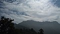
Chandragiri Cable Car is a gondola lift transportation system located in Chandragiri Municipality, Nepal. Opened in 2016, the Chandragiri Cable Car runs from Thankot to Chandragiri hills. The 2.4km (9,095ft) line has two stations. The cable car system consists of 38 gondolas that can carry 1,000 people per hour. [4] [5] [6] Bhaleshwor Mahadev temple is situated at the top of Chandragiri hills.

Contents

The 2.4 km cable car ride takes 9 minutes to reach the Chandragiri Hills’ top station. A cabin accommodates 8 passengers. A child above 3 feet of height requires a ticket.

Ticket rates

Ticket rates [7]
Nepalese SAARC Chinese FOREIGN
ONE WAY NPR 495NPR 790 USD 9USD 13
ROUND TRIPNPR 825NPR 1320USD 16USD 23

See also

Related Research Articles

<span class="mw-page-title-main">Aerial tramway</span> Aerial lift in which the cars are permanently fixed to the cables

An aerial tramway, aerial tram, sky tram, aerial cablecar, aerial cableway, telepherique, or seilbahn is a type of aerial lift which uses one or two stationary ropes for support while a third moving rope provides propulsion. With this form of lift, the grip of an aerial tramway cabin is fixed onto the propulsion rope and cannot be decoupled from it during operations. In comparison to gondola lifts, aerial tramways generally provide lower line capacities and higher wait times.

<span class="mw-page-title-main">Bagmati River</span> River in Nepal

The Bagmati River flows through the Kathmandu valley of Nepal, separating the cities of Kathmandu and Patan, before flowing through Madesh Province of southern Nepal and joining the Kamla River in the Indian state of Bihar. It is considered holy by both Hindus and Buddhists. A number of Hindu temples are located on its banks.

<span class="mw-page-title-main">Pokhara</span> Metropolitan city in Gandaki Province, Nepal

Pokhara is a metropolitan city in central Nepal, which serves as the capital of Gandaki Province and the tourism capital of Nepal. It is the second most populous city of Nepal after Kathmandu, with 599,504 inhabitants living in 120,594 households in 2021. It is the country's largest metropolitan city in terms of area. The city also serves as the headquarters of Kaski District. Pokhara is located 200 kilometres west of the capital, Kathmandu. The city is on the shore of Phewa Lake, and sits at an elevation of approximately 822 m. The Annapurna Range, with three out of the ten highest peaks in the world—Dhaulagiri, Annapurna I and Manaslu—is within 15–35 mi (24–56 km) of the valley.

<span class="mw-page-title-main">Kathmandu Valley</span> Valley and proposed territory in Nepal

The Kathmandu Valley, also known as the Nepal Valley or Nepa Valley, National Capital Area, is a bowl-shaped valley located in the Himalayan mountains of Nepal. It lies at the crossroads of ancient civilizations of the Indian subcontinent and the broader Asian continent, and has at least 130 important monuments, including several pilgrimage sites for Hindus and Buddhists. There are seven World Heritage Sites within the valley.

<span class="mw-page-title-main">Kavrepalanchok District</span> District in Bagmati Province, Nepal

Kavrepalanchok District is one of the 77 districts of Nepal. The district, with Dhulikhel as its district headquarters, covers an area of 1,396 km2 (539 sq mi). It is a part of Bagmati Province and has a population of 364,039.

<span class="mw-page-title-main">Manakamana Temple</span> Temple in Gorkha, Nepal

Manakamana Temple is a Hindu temple dedicated to goddess Bhagwati, an incarnation of Parvati and it is situated in the village of Manakamana in Gorkha District, Gandaki Province, Nepal founded by Arman Rayamajhi in 1678.

<span class="mw-page-title-main">Genting Skyway</span> Gondola lift in Genting Highlands, Malaysia

Genting Skyway is a gondola lift connecting Gohtong Jaya and Resort Hotel in Genting Highlands, Selangor, Malaysia. Its lower station at Gohtong Jaya township, located approximately 51 kilometres (32 mi) northeast of Kuala Lumpur, comprises a 5-storey station building and a 10-storey car park while its upper station is located at the Highlands Hotel.

<span class="mw-page-title-main">Balambu</span> Village of Chandragiri Municipality in No. 3, Nepal

Balambu is a village and former Village Development Committee that is now part of Chandragiri Municipality in Kathmandu District in Province No. 3 of central Nepal. At the time of the 2011 Nepal census it had a population of 7,323 and had 1,734 houses in it. Porters play a vital role in Nepal's tourism industry; every year they support thousands of tourists in tackling the iconic trails of the Everest region. Often climbing multiple time during the high season, the trekking industry provides an income that helps porters earn a living and support their families. However, they are also often the least valued on the mountain and because of the pressures to get an income can face exploitation and mistreatment from trekking operators. To address these issues, Kathmandu Environmental Education Program (KEEP) has created the Porter Awareness and Welfare training program. This provides porters with information about their work rights as well as health, hygiene and general First Aid skills. The program also offers guidance on appropriate trekking clothing and gear, and how to access KEEP's Porter Clothing Centre, which loans warm clothing and appropriate footwear to porters.

Machhegaun is a village and former Village Development Committee that is now part of Chandragiri Municipality in Kathmandu District in Province No. 3 of central Nepal. At the time of the 1991 Nepal census it had a population of 2,871.

<span class="mw-page-title-main">Thankot</span> Village of Chandragiri Municipality in No. 3, Nepal

Thankot is a village and former Village Development Committee that is now part of Chandragiri Municipality in Kathmandu District in Province No. 3 of central Nepal. It lies in the lap of Chandragiri Hill. According to the 2011 Nepal census it has a population of 12,047 and has 2,820 households.

Chitlang is a village located in Thaha Municipality of Makwanpur District, Bagmati Province, Nepal. Religions of chitlang

<span class="mw-page-title-main">Manakamana Cable Car</span>

The Manakamana Cable Car is a gondola lift transportation system located in Chitwan, Nepal. The 2,772.2 m (9,095 ft) line has two stations, connecting Kurintar, Chitwan to Manakamana temple, Gorkha. It provides an aerial link from the base station located inside the cable car station to the peak of the Kafakdada hill, where the Manakamana Temple is located at 1300 metres above sea level and from which the cable car receives its name.

<span class="mw-page-title-main">Awana Skyway</span> Aerial lift in Pahang, Malaysia

The Awana Skyway, also referred to as the new Awana Skyway, is a gondola lift system connecting Awana Transport Hub, Chin Swee Temple and SkyAvenue in Genting Highlands, Pahang, Malaysia since December 2016. The Awana Transport Hub terminus consists of the new Awana Bus Terminal, the station building and a new 8-storey car park while the other terminus is located at SkyAvenue.

<span class="mw-page-title-main">Chandragiri Municipality</span> Municipality in Central, Nepal

Chandragiri is a municipality in Kathmandu District in Bagmati Province of Nepal that was declared as municipality on 2 December 2014 by merging the former Village Development Committees Baad Bhanjyang, Balambu, Dahachok, Mahadevsthan, Machhegaun, Matatirtha, Naikap Naya Bhanjyang, Naikap Purano Bhanjyang, Satungal, Thankot and Tinthana. The urban administration is located in Balambu. The city's main attractions include Chandragiri Hill, Nepal with its Cable Car and Matatirtha which is famous for the Matatirtha Aunsi festival, a day to honour mothers and motherhood.

<span class="mw-page-title-main">Bagmati Province</span> Province in central Nepal

Bagmati Province is one of the seven provinces of Nepal established by the constitution of Nepal. Bagmati is Nepal's second-most populous province and fifth largest province by area. It is bordered by Tibet Autonomous Region of China to the north, Gandaki Province to the west, Koshi Province to the east, Madhesh Province and the Indian state of Bihar to the south. With Hetauda as its provincial headquarters, the province is also the home to the country's capital Kathmandu, is mostly hilly and mountainous, and hosts mountain peaks including Gaurishankar, Langtang, Jugal, and Ganesh.

<span class="mw-page-title-main">Chandragiri Hill (Nepal)</span>

Chandragiri Hill is seven kilometres from Thankot, and lies on the south-west side of Kathmandu Valley which is 2551 metres above sea level. The hill provides panoramic views of Kathmandu Valley and the Himalayan ranges from Annapurna to Everest. Chandragiri Hill has cable car system to reach the temple of Bhaleshwor Mahadev. Chandragiri is where Prithivi Narayan Shah decided to annex the beautiful Nepal valley into his Gorkha Kingdom.

<span class="mw-page-title-main">Bhaleshwor Mahadev</span> Hindu temple in Nepal

Bhaleshwor Mahadev is a Hindu temple located in Chandragiri hill in south-west side of Kathmandu Valley. It is dedicated to Lord Shiva. It is located at the altitude of 2551 meters above sea level. The temple was built by Chandragiri Hills on the historic and religious site. The temple was designed by the architect Shankar Nath Rimal. The temple is connected to the Kathmandu valley by a cable car.

Ropeways in Nepal, which mainly refer to the aerial ropeways, are used for human and cargo transport. In the ‘Nepal Country Report’ of 1976 by the world bank concluded that construction and maintenance of roads in mountainous are costly due to hilly terrain, and thus other means of transport should be studied mainly indicating to the ropeways. However, ropeways have not gained significant popularity over roadways. In the Ninth Five-year Plan ropeway was encouraged with and involvement of the private sector. But no provision in the national budget was made for ropeway development. Nonetheless, private sector has initiated the construction and operation of ropeways mainly in lucrative places such as religious temple.

References

  1. "'Govt ready to partner with private sector'". The Himalayan Times. Retrieved 19 December 2016.
  2. "What is Chandragiri Hills Ltd?". Chandragiri Hills Ltd. Retrieved 19 December 2016.
  3. "Thankot-Chandragiri". Doppelmayr Seilbahnen GmbH. Retrieved 19 December 2016.
  4. "Chandragiri cable car carries 20k visitors in first fortnight". The Kathmandu Post. Retrieved 18 December 2016.
  5. "Chandragiri cable car". The Himalayan Times. Archived from the original on 20 December 2016. Retrieved 19 December 2016.
  6. "Up, up and Chandragiri: Kathmandu's first cable car to be launched within a month". Onlinekhabar English. Archived from the original on 20 December 2016. Retrieved 19 December 2016.
  7. "Cable Car". Chandragiri Hills. Retrieved 2020-05-28.