Channel River

Last updated

The Channel River was a prehistoric river flowing between England and France during periods of low sea level during the ice ages. Its tributaries included the river Rhine in modern-day Netherlands, the River Thames in modern-day England and other rivers. Over the last 12,000 years rising seas have covered its course, through what is now the English Channel.

Contents

Formation

Map showing hypothetical extent of Doggerland from Weichselian glaciation until the current situation Doggerland3er en.png
Map showing hypothetical extent of Doggerland from Weichselian glaciation until the current situation

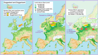
Paleogeographers studying the Quaternary period have suggested that 600,000 years ago, although the Channel and the North Sea were flooded, the Weald-Artois ridge remained as a land bridge between Britain and Continental Europe, [1] allowing people, plants and animals to cross. [2] This barrier also separated the drainage basins of the rivers, with the Rhine and the Thames forced to flow into the North Sea.

A bathymetric study of the morphology of the current Channel floor in 2007 [3] found evidence suggesting that the ridge was eroded by two 'megafloods' between 180,000 and 450,000 years ago. During periods of glaciation the British and the Fennoscandian ice sheets trapped water, preventing it from flowing north, and together with the land bridge to the south formed a glacial lake. The lake grew as the rivers continued to pour into it until it finally breached the southern ridge, creating what the paper called the 'Fleuve Manche', translating to Channel River, flowing through the vast shallow valley of the Channel Basin and into the Bay of Biscay.

This westward-flowing Channel River carried water not only from the rivers that currently enter the Channel, but also from those that now drain into the southern North Sea, among them the Rhine, Meuse, Thames and Scheldt, [4] making it larger than any river in modern-day Europe.

The erosion from two such breaches left a significant gap in the ridge, so when the ice melted and the seas rose, water covered the area, cutting Britain off. Since the last ice age, around 12,000 years ago, the current Channel formed, and the Strait of Dover is now a 32 km (20 mi) wide gap in the ridge, bordered by cliffs of between 15 and 45 m (49 and 148 ft) high on both the Kent and the Calais sides. [1]

Studies

Unfortunately erosion along the coastline made it difficult to analyse sedimentary deposits, and to get a clear picture of what happened so long ago. This is why a team of Anglo-French scientists studied sedimentary deposits in the Bay of Biscay, where they will have remained undisturbed at the bottom of the sea for thousands of years. Their findings were published in 2009, and added more detail to the process of separation, and concluded that Britain and France were separated by a "super-river" during three periods of glaciation. [5]

See also

Related Research Articles

<span class="mw-page-title-main">Ice age</span> Period of long-term reduction in temperature of Earths surface and atmosphere

An ice age is a long period of reduction in the temperature of Earth's surface and atmosphere, resulting in the presence or expansion of continental and polar ice sheets and alpine glaciers. Earth's climate alternates between ice ages, and greenhouse periods during which there are no glaciers on the planet. Earth is currently in the ice age called Quaternary glaciation. Individual pulses of cold climate within an ice age are termed glacial periods, and intermittent warm periods within an ice age are called interglacials or interstadials.

<span class="mw-page-title-main">Strait of Dover</span> Strait at the narrowest part of the English Channel

The Strait of Dover or Dover Strait, is the strait at the narrowest part of the English Channel, marking the boundary between the Channel and the North Sea, and separating Great Britain from continental Europe. The shortest distance across the strait, at approximately 20 miles, is from the South Foreland, northeast of Dover in the English county of Kent, to Cap Gris Nez, a cape near to Calais in the French département of Pas-de-Calais. Between these points lies the most popular route for cross-channel swimmers. The entire strait is within the territorial waters of France and the United Kingdom, but a right of transit passage under the United Nations Convention on the Law of the Sea allows vessels of other nations to move freely through the strait.

<span class="mw-page-title-main">Last Glacial Period</span> Period of major glaciations of the Northern Hemisphere (115,000–12,000 years ago)

The Last Glacial Period (LGP), also known colloquially as the Last Ice Age or simply Ice Age, occurred from the end of the Last Interglacial to the end of the Younger Dryas, encompassing the period c. 115,000 – c. 11,700 years ago.

In geomorphology, an outburst flood—a type of megaflood—is a high-magnitude, low-frequency catastrophic flood involving the sudden release of a large quantity of water. During the last deglaciation, numerous glacial lake outburst floods were caused by the collapse of either ice sheets or glaciers that formed the dams of proglacial lakes. Examples of older outburst floods are known from the geological past of the Earth and inferred from geomorphological evidence on Mars. Landslides, lahars, and volcanic dams can also block rivers and create lakes, which trigger such floods when the rock or earthen barrier collapses or is eroded. Lakes also form behind glacial moraines or ice dams, which can collapse and create outburst floods.

<span class="mw-page-title-main">Goring Gap</span> River Thames valley in south east England

The Goring Gap is a topographical feature on the course of the River Thames. The Gap is located in southern England where the river, flowing from north to south, cuts through and crosses a line of chalk hills in a relatively narrow gap between the Chiltern Hills and the Berkshire Downs. The Gap is approximately 10 miles (16 km) upstream of Reading and 27 miles (43 km) downstream of Oxford. The Gap is named after the town of Goring-on-Thames in Oxfordshire. That town is on the east bank of the river at Goring Gap, and Streatley is immediately opposite, on the west bank.

<span class="mw-page-title-main">Bytham River</span> Former pleistocene river in England

The Bytham River is said to have been one of the great Pleistocene rivers of central and eastern England until it was destroyed by the advancing ice sheets of the Anglian Glaciation around 450,000 years ago. The river is named after Castle Bytham in Lincolnshire, where the watercourse is said to have crossed the Lincolnshire limestone hills in a valley now buried by Anglian till. West of that location, its catchment area included much of Warwickshire, Leicestershire and Derbyshire. East of that location, the Bytham flowed across what is now the Fen Basin to Shouldham, then southward to Mildenhall, then eastward across East Anglia. It met the Proto-Thames in a delta near what is now the Norfolk/Suffolk border and flowed into the North Sea. Britain was then joined to the Continent by a land bridge and the Bytham joined the North Sea somewhere beyond the northern end of that land bridge.

<span class="mw-page-title-main">Timeline of glaciation</span> Chronology of the major ice ages of the Earth

There have been five or six major ice ages in the history of Earth over the past 3 billion years. The Late Cenozoic Ice Age began 34 million years ago, its latest phase being the Quaternary glaciation, in progress since 2.58 million years ago.

<span class="mw-page-title-main">Anglian stage</span> Period of the Pleistocene epoch

The Anglian Stage is the name used in the British Isles for a middle Pleistocene glaciation. It precedes the Hoxnian Stage and follows the Cromerian Stage in the British Isles. The Anglian Stage is correlated to Marine Isotope Stage 12, which started about 478,000 years ago and ended about 424,000 years ago.

The Wolstonian Stage is a middle Pleistocene stage of the geological history of Earth from approximately 374,000 until 130,000 years ago. It precedes the Eemian Stage in Europe and follows the Hoxnian Stage in the British Isles.

<span class="mw-page-title-main">Quaternary glaciation</span> Series of alternating glacial and interglacial periods

The Quaternary glaciation, also known as the Pleistocene glaciation, is an alternating series of glacial and interglacial periods during the Quaternary period that began 2.58 Ma and is ongoing. Although geologists describe this entire period up to the present as an "ice age", in popular culture this term usually refers to the most recent glacial period, or to the Pleistocene epoch in general. Since Earth still has polar ice sheets, geologists consider the Quaternary glaciation to be ongoing, though currently in an interglacial period.

The Ancestral Thames is the geologically ancient precursor to the present day River Thames. The river has its origins in the emergence of Britain from a Cretaceous sea over 60 million years ago. Parts of the river's course were profoundly modified by the Anglian glaciation some 450,000 years ago. The extensive terrace deposits laid down by the Ancestral Thames over the past two million years or so have provided a rich source of material for studies in geology, geomorphology, palaeontology and archaeology.

The Lea Valley, the valley of the River Lea, has been used as a transport corridor, a source of sand and gravel, an industrial area, a water supply for London, and a recreational area. The London 2012 Summer Olympics were based in Stratford, in the Lower Lea Valley. It is important for London's water supply, as the source of the water transported by the New River aqueduct, but also as the location for the Lee Valley Reservoir Chain, stretching from Enfield through Tottenham and Walthamstow.

<span class="mw-page-title-main">Geology of England</span> Overview of the geology of England

The geology of England is mainly sedimentary. The youngest rocks are in the south east around London, progressing in age in a north westerly direction. The Tees–Exe line marks the division between younger, softer and low-lying rocks in the south east and the generally older and harder rocks of the north and west which give rise to higher relief in those regions. The geology of England is recognisable in the landscape of its counties, the building materials of its towns and its regional extractive industries.

<span class="mw-page-title-main">Turkey Brook</span> River in the northern outskirts of London

Turkey Brook is a river in the northern outskirts of London. It rises in Potters Bar, Hertfordshire, and flows broadly eastwards to merge with the River Lea Navigation near Enfield Lock.

<span class="mw-page-title-main">Pymmes Brook</span> River in north London

Pymmes Brook is located in North London and named after William Pymme, a local land owner. It is a minor tributary of the River Lea. The brook mostly flows through urban areas and is particularly prone to flooding in its lower reaches. To alleviate the problem the brook has been culverted in many areas. Part of it is a Site of Borough Importance for Nature Conservation, Grade II.

<span class="mw-page-title-main">Salmons Brook</span> River in London

Salmons Brook is a minor tributary of the River Lea, located in the London Borough of Enfield.

<span class="mw-page-title-main">Phil Gibbard</span>

Philip Leonard Gibbard is a Quaternary geologist and has been Professor of Quaternary Palaeoenvironments in the University of Cambridge, Department of Geography since 2005. A PhD student of Professor Richard Gilbert West in the Subdepartment of Quaternary Research, University of Cambridge (1971–1974), he investigated the diversion of the River Thames from its course through Hertfordshire to its present course through London. Later he established the stratigraphy and palaeogeography of the Thames in the Middle (1985) and Lower Thames Valley (1994). He has since undertaken many collaborative, palaeoenvironmental investigations. This multidisciplinary approach has led to him working throughout Britain, offshore areas, especially the North Sea, English Channel and the formation of the Strait of Dover, and neighbouring countries. For an example of this work, see Britain's island heritage: reconstructing half a million years of history.

<span class="mw-page-title-main">Cuffley Brook</span> River in Hertfordshire, England

Cuffley Brook is a tributary of Turkey Brook. It runs through parts of Hertfordshire and the London Borough of Enfield, England. After the confluence of the two streams in Whitewebbs Park, the watercourse continues eastwards as Turkey Brook to join the River Lea near Enfield Lock.

<span class="mw-page-title-main">Geology of the North Sea</span> Description of the current geological features and the geological history that created them

The geology of the North Sea describes the geological features such as channels, trenches, and ridges today and the geological history, plate tectonics, and geological events that created them.

An urstromtal is a type of broad glacial valley, for example, in northern Central Europe, that appeared during the ice ages, or individual glacial periods of an ice age, at the edge of the Scandinavian ice sheet and was formed by meltwaters that flowed more or less parallel to the ice margin. Urstromtäler are an element of the glacial series. The term is German and means "ancient stream valley". Although often translated as "glacial valley", it should not be confused with a valley carved out by a glacier. More accurately some sources call them "meltwater valleys" or "ice-marginal valleys".

References

  1. 1 2 Gibbard, Philip (3 October 2007). "How Britain became an island". Nature Precedings. doi: 10.1038/npre.2007.1205.1 . Retrieved 27 November 2019.
  2. Edwards, Lin (2 December 2009). "'Super-river' formed the English Channel". Phys.org. ScienceX. Retrieved 27 November 2019.
  3. Gupta, Sanjeev; Collier, Jenny S.; Palmer-Felgate, Andy; Potter, Graeme (July 2007). "Catastrophic flooding origin of shelf valley systems in the English Channel". Nature. 448 (7151): 342–345. Bibcode:2007Natur.448..342G. doi:10.1038/nature06018. PMID   17637667. S2CID   4408290.
  4. Gibbard, Philip (18 July 2007). "Europe cut adrift". Nature. 448 (7151): 259–260. doi: 10.1038/448259a . PMID   17637645. S2CID   4400105.
  5. Toucanne, S.; Zaragosi, S.; Bourillet, J.F.; Cremer, M.; Eynaud, F.; Van Vliet-Lanoë, B.; Penaud, A.; Fontanier, C.; Turon, J.L.; Cortijo, E. (June 2009). "Timing of massive 'Fleuve Manche' discharges over the last 350kyr: insights into the European ice-sheet oscillations and the European drainage network from MIS 10 to 2". Quaternary Science Reviews. 28 (13–14): 1238–1256. Bibcode:2009QSRv...28.1238T. doi:10.1016/j.quascirev.2009.01.006. S2CID   15918646.