
Bridgwater is a historic market town and civil parish in Somerset, England. The town had a population of 41,276 at the 2021 census. Bridgwater is at the edge of the Somerset Levels, in level and well-wooded country. The town lies along both sides of the River Parrett; it has been a major inland port and trading centre since the industrial revolution. Most of its industrial bases still stand today. Its larger neighbour, Taunton, is linked to Bridgwater via a canal, the M5 motorway and the GWR railway line.

Ilminster is a market town and civil parish in the South Somerset district of Somerset, England, with a population of 5,808. Bypassed in 1988, the town now lies just east of the junction of the A303 and the A358. The parish includes the hamlet of Sea.
Chard is a town and a civil parish in the English county of Somerset. It lies on the A30 road near the Devon and Dorset borders, 15 miles (24 km) south west of Yeovil. The parish has a population of approximately 14,000 and, at an elevation of 121 metres (397 ft), Chard is the southernmost and one of the highest towns in Somerset. Administratively Chard forms part of the district of South Somerset.
Crewkerne is a town and electoral ward in south Somerset, England, 9 miles (14 km) southwest of Yeovil and 7 miles (11 km) east of Chard. The civil parish of West Crewkerne includes the hamlets of Coombe, Woolminstone and Henley, and borders the county of Dorset to the south. The town is on the main headwater of the River Parrett, A30 road and West of England Main Line railway, in modern times the slower route between the capital and the southwest peninsula, having been eclipsed by the Taunton route.

Merriott is a village and civil parish in Somerset, England, near the town of Crewkerne and 7 miles (11.3 km) west of Yeovil in the South Somerset district. The village has a population of 1,979.

Ashill is a small village and civil parish in Somerset, England, situated 7 miles (11.3 km) south of Taunton, and three miles north-west of Ilminster. The parish includes the hamlet of Windmill Hill and has a population of 529.
Dowlish Wake is a small village and civil parish in Somerset, England, 2 miles (3 km) south of Ilminster and 5 miles (8 km) northeast of Chard in the South Somerset district. With a population of 277, it has several thatched houses and a pub, the New Inn. Its post office closed in 1991.

Broadway is a village and civil parish in Somerset, England, situated 3 miles (4.8 km) west of Ilminster and 5 miles (8.0 km) north of Chard. The parish has a population of 740. The parish includes the nearby hamlet of Hare.

Chaffcombe is a village and civil parish in Somerset, England, situated 2 miles (3.2 km) north east of Chard in the South Somerset district. The village has a population of 229.

Donyatt is a village and civil parish in Somerset, England, situated at the source of the River Isle 5 miles (8.0 km) north of Chard in the South Somerset district. The village has a population of 347. The parish includes the hamlet of Peasmarsh.

Prior Park College is a mixed Catholic public school for both boarding and day pupils in Bath, south-west England. Its main building, Prior Park, stands on a hill overlooking the city and is a Grade I listed building. The adjoining 57-acre (23 ha) Prior Park Landscape Garden was donated by Prior Park to the National Trust.
The Blake Museum is in Bridgwater, Somerset, England at what is believed to be the birthplace of Robert Blake, General at Sea (1598–1657). Since April 2009 it has been run by Bridgwater Town Council with help from the Friends of Blake Museum. It has been an Accredited Museum since 2006. It is next door to the Bridgwater Town Mill, and there are plans to develop this as an extension of the museum.
The Bishop's Palace is the residence of the bishop of Bath and Wells in Wells, Somerset, England. The palace is adjacent to Wells Cathedral and has been the residence of the bishops since the early thirteenth century. It has been designated a grade I listed building.

South Petherton is a large village and civil parish in the South Somerset district of Somerset, England, located 5 miles (8 km) east of Ilminster and 5 miles (8 km) north of Crewkerne. The parish had a population of 3,737 in 2021 and includes the smaller village of Over Stratton and the hamlets of Compton Durville, Drayton, Wigborough and Yeabridge. The River Parrett forms the eastern boundary of the parish. The village is approximately 2 miles (3 km) from East Lambrook, Martock and Lopen.

Nailsea Court in Nailsea, Somerset, England, is an English manor house dating from the 15th century. Pevsner describes the house as "historically highly instructive and interesting" and it is a Grade I listed building.
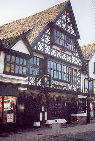
The Tudor Tavern at No 15 Fore Street, Taunton, Somerset, England has been designated as a Grade I listed building. Built in 1578, the house is three storeys high of a timber-frame construction, with jettied first and second floors. The frontage is of carved bressummers with interlocking curved braces, while the roof is red tiles. There is a medieval hall with an open trussed roof behind the front.

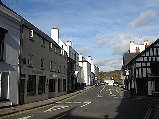
Fore Street in Chard, Somerset, England was built in the late 16th and early 17th century, following a fire which destroyed much of the town in 1577.
St James Street is a historic street in the town centre of Monmouth, Monmouthshire, Wales. It appears as a segment of Whitecross Street on the 1610 map of the town by cartographer John Speed and is within the medieval town walls. On more recent maps, it extends from St James Square southwest to Almshouse Street. In 2010, the street was the site of discovery of Mesolithic era artefacts. St James Street is lined with numerous listed buildings.

North Perrott Manor House which later became Perrott Hill School in North Perrott, Somerset, England was built in 1877 by Thomas Henry Wyatt. It is a Grade II* listed building.

The Guildhall is a town hall and community building in the town of Chard in the English county of Somerset.


