
The Saddlehorn Caretaker's House and Garage, also known as the Stone House, the Rock House, and the Superintendent's Quarters is a house and asset listed as part of the National Register of Historic Places located in the Colorado National Monument.

The Alvin Miller House is a Usonian home beside the Cedar River in Charles City, Iowa. It was designed by Frank Lloyd Wright and constructed over a five-year period completed in 1951. The single-story structure features a two-level flat roof which allows for clerestory windows. It was severely damaged in the flood of 2008. Restoration efforts surrounding the house after the flooding are detailed in the Alvin Miller House website.

The Redding Center Historic District is a 55-acre (22 ha) located in Redding, Connecticut, encompassing its historic village center. It includes the town's current and former town halls, a church, a cemetery, private homes and barns. The district was added to the National Register of Historic Places on October 1, 1992.
This is a list of the properties and historic districts in Stamford, Connecticut that are listed on the National Register of Historic Places. The locations of National Register properties and districts for which the latitude and longitude coordinates are included below, may be seen in an online map.
This is a list of the National Register of Historic Places listings in Greenwich, Connecticut.
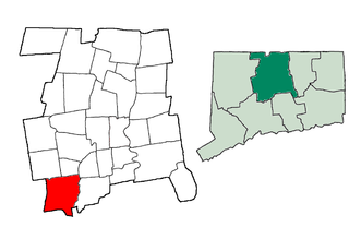
This is a list of the National Register of Historic Places listings in Southington, Connecticut.
Holy Rosary Church in Bridgeport is a Catholic Church in Diocese of Bridgeport.
This is a list of the National Register of Historic Places listings in Glacier National Park.
This is a complete list of the properties and districts on the National Register of Historic Places in Rocky Mountain National Park, Colorado, United States. The locations of National Register properties and districts for which the latitude and longitude coordinates are included below, may be seen in a map.

The Sexton House in Goleta, California is a two-story Italianate style house that was built in 1880. It was designed by architect Peter J. Barber.
This is a list of the National Register of Historic Places listings in Zion National Park.
This is a list of the National Register of Historic Places listings in Cuyahoga Valley National Park.
This is a list of the National Register of Historic Places listings in Wind Cave National Park.

This is a list of the National Register of Historic Places listings in Bell County, Kentucky.
The East Capitol Car Barn, also known as The Car Barn Condominiums, is an historic building, located at 1400 East Capitol Street, Northeast, Washington, D.C., in the Capitol Hill neighborhood.

Prospect House is a historic building, located at 3508 Prospect Street, Northwest, Washington, D.C., in the Georgetown neighborhood.

The Wetzell-Archbold Farmstead is an historic stone and log farmhouse, located at 4437 Reservoir Road, Northwest, Washington, D.C., in the Foxhall neighborhood.

The Pierce Springhouse and Barn, also known as the Art Barn, is an historic barn and springhouse located in Rock Creek Park, at Tilden Street and Beach Drive, Northwest, Washington, D.C.

The James W. Clise House is a house built for and occupied by Seattle real estate pioneer James W. Clise (1855–1939) and his wife Anna Herr Clise (1866–1936). The house and 440-acre model dairy farm became Marymoor Park in Redmond, Washington, United States, and the house is listed on the National Register of Historic Places.


