Charleston most commonly refers to:

West Virginia is a landlocked state in the Southern and Mid-Atlantic regions of the United States. It is bordered by Pennsylvania to the north and east, Maryland to the east and northeast, Virginia to the southeast, Kentucky to the southwest, and Ohio to the northwest. West Virginia is the 10th-smallest state by area and ranks as the 12th-least populous state, with a population of 1,793,716 residents. The capital and most populous city is Charleston with a population of 49,055.

Charleston is the capital and most populous city of the U.S. state of West Virginia and the county seat of Kanawha County. Located at the confluence of the Elk and Kanawha rivers, the city had a population of 48,864 at the 2020 census and an estimated population of 48,018 in 2021. The Charleston metropolitan area had 308,248 residents in 2020.
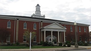
Mississippi County is a county located in the Bootheel of the U.S. state of Missouri, with its eastern border formed by the Mississippi River. As of the 2020 census, the population was 12,577. The largest city and county seat is Charleston. The county was officially organized on February 14, 1845, and was named after the Mississippi River.

Tallahatchie County is a county in the U.S. state of Mississippi. At the 2020 census, the population was 12,715. Its county seats are Charleston and Sumner.

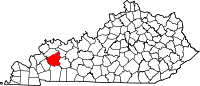
Hopkins County is a county located in the western part of the U.S. state of Kentucky. As of the 2020 census, the population was 45,423. Its county seat is Madisonville. Hopkins County was created December 9, 1806, from Henderson County. It was named for General Samuel Hopkins, an officer in both the American Revolutionary War and War of 1812, and later a Kentucky legislator and U.S. Congressman.

Charleston is a city in, and the county seat of, Coles County, Illinois, United States. The population was 17,286, as of the 2020 census. The city is home to Eastern Illinois University and has close ties with its neighbor, Mattoon. Both are principal cities of the Charleston–Mattoon Micropolitan Statistical Area.

Mattoon is a city in Coles County, Illinois, United States. The population was 16,870 as of the 2020 census. The city is home to Lake Land College and has close ties with its neighbor, Charleston. Both are principal cities of the Charleston–Mattoon Micropolitan Statistical Area.

Ashland is a home rule-class city in Boyd County, Kentucky, United States. The largest city in Boyd County, Ashland is located upon a southern bank of the Ohio River at the state border with Ohio and near West Virginia. The population was 21,625 at the 2020 census. Ashland is a principal city of the Huntington–Ashland metropolitan area, referred to locally as the "Tri-State area", home to 376,155 residents as of 2020. Ashland serves as an important economic and medical center for northeastern Kentucky.

Boonesborough or Boonesboro is an unincorporated community in Madison County, Kentucky, United States. Founded by famed frontiersman Daniel Boone in 1775 as one of the first English-speaking settlements west of the Appalachian Mountains, Boonesborough lies in the central part of the state along the Kentucky River and is the site of Fort Boonesborough State Park, which includes the Kentucky River Museum. The park site has been rebuilt to look like a working fort of the time that Boone resided there.

U.S. Route 119 (US 119) is a spur of US 19. It is a north–south route that was an original United States highway of 1926. It is Corridor G of the Appalachian Development Highway System (ADHS) east of US 23 and KY 80 in Kentucky to Interstate 64 at Charleston, West Virginia.

The 1860 Democratic National Conventions were a series of presidential nominating conventions held to nominate the Democratic Party's candidates for president and vice president in the 1860 election.

Larry Elmore is an American fantasy artist whose work includes creating illustrations for video games, comics, magazines, and fantasy books. His list of work includes illustrations for Dungeons & Dragons, Dragonlance, and his own comic strip series SnarfQuest. He is author of the book Reflections of Myth.

Shoney's is an American restaurant chain headquartered in Nashville, Tennessee. As of April 2024, the company operates 58 locations in Alabama, Florida, Georgia, Kentucky, Louisiana, Missouri, North Carolina, Ohio, Oklahoma, Pennsylvania, South Carolina, Tennessee, Virginia, and West Virginia.

Southern West Virginia is a culturally and geographically distinct region in the U.S. state of West Virginia. Southern West Virginia has coal mining heritage and Southern affinity. The region is also closely identified with Southwestern Virginia and Eastern Kentucky, with close proximity to Western North Carolina and East Tennessee.
Springdale is a neighborhood in Louisville, Kentucky located along Brownsboro Road and Barbour Lane. The community is named for the family farm purchased by Laurence Young and his family in 1830, which was intersected by present-day Brownsboro Road, with the estate on the south side of the road. The Young family's Springdale farm today is the site of the Standard Country Club, as well as portions of Barbourmeade, Goose Creek and Brownsboro Farm. Though it is not a formally recognized neighborhood or district within Louisville, nor does it have official boundaries, older businesses and institutions in the community still retain the Springdale name, and the name was used to refer to the area until it was subdivided in the 1950s and '60s.
The Charleston Metropolitan Statistical Area, as defined by the United States Census Bureau, is an area consisting of three counties in West Virginia, anchored by the city of Charleston. It is the largest metropolitan area entirely within the state of West Virginia. The Huntington Metro Area adds to the Charleston–Huntington, WV-OH-KY CSA and spans three states, while the core county of the Charleston area, Kanawha County, is more populous than the West Virginia portion of the Huntington area.
The Episcopal Diocese of West Virginia is a diocese of the Episcopal Church in the United States of America (TEC). It encompasses all 55 counties of West Virginia. The diocese has 66 congregations, including 38 parishes, 26 missions, and 2 other churches. The diocese is headquartered in Charleston and led by The Rt. Rev. Matthew Davis Cowden who was consecrated as bishop coadjutor in March, 2022 and became bishop diocesan in October, 2022.
The Huntington–Ashland metropolitan area is a metropolitan area in the Appalachian Plateau region of the United States. Referred to locally as the "Tri-State area," and colloquially as "Kyova", the region spans seven counties in the three states of Kentucky, Ohio, and West Virginia. With a population of 361,580, the Tri-State area is nestled along the banks of the Ohio River. The region offers a diverse range of outdoor activities.
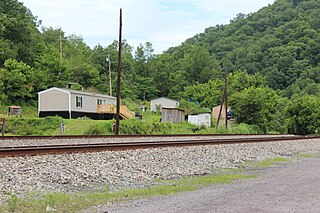
Vulcan is an unincorporated community in Mingo County, West Virginia, United States. Vulcan is located along the Tug Fork across from the state of Kentucky. The community was named after Vulcan, the god of fire in Roman mythology. Vulcan received international attention when they requested aid from the Soviet Union to replace a collapsed bridge, the only legal entrance and exit into the community.