Cheapside, Texas

Last updated
Cheapside, Texas
Ghost town
USA Texas location map.svg
Red pog.svg
Cheapside
Usa edcp location map.svg
Red pog.svg
Cheapside
Coordinates: 29°16′42″N97°24′11″W / 29.27833°N 97.40306°W / 29.27833; -97.40306 Coordinates: 29°16′42″N97°24′11″W / 29.27833°N 97.40306°W / 29.27833; -97.40306
Country United States
State Texas
County Gonzales
Elevation 299 ft (91 m)
Time zone Central (CST) (UTC-6)
  Summer (DST) CDT (UTC-5)
GNIS feature ID 1354334 [1]

Cheapside is a ghost town in Gonzales County, Texas. It is located 21 mi (34 km) south of Gonzales. [1]

Ghost town city depopulated of inhabitants and that stays practically intact

A ghost town is an abandoned village, town, or city, usually one that contains substantial visible remains. A town often becomes a ghost town because the economic activity that supported it has failed, or due to natural or human-caused disasters such as floods, prolonged droughts, government actions, uncontrolled lawlessness, war, pollution, or nuclear disasters. The term can sometimes refer to cities, towns, and neighbourhoods that are still populated, but significantly less so than in past years; for example, those affected by high levels of unemployment and dereliction.

Gonzales County, Texas County in the United States

Gonzales County is a county in the U.S. state of Texas. As of the 2010 census, its population was 19,807. The county is named for its county seat, the city of Gonzales. The county was created in 1836 and organized the following year.

Gonzales, Texas City in Texas, United States

Gonzales is a city in Gonzales County, Texas, United States. The population was 7,237 at the 2010 census. It is the county seat.

Contents

Once a thriving community and commercial center for cotton, only a church and the crumbling remnants of the former settlement remain.

History

The first settler was Thomas Baker, who built a log cabin in the area in 1857. [2]

The settlement was named after Cheapside Street in London, England, [3] [4] perhaps via Cheapside, Virginia. [2]

Cheapside street in the City of London

Cheapside is a street in the City of London, the historic and modern financial centre of London, which forms part of the A40 London to Fishguard road. It links St. Martin's Le Grand with Poultry. Near its eastern end at Bank junction, where it becomes Poultry, is Mansion House, the Bank of England, and Bank station. To the west is St. Paul's Cathedral, St. Paul's tube station and square.

Cheapside is an unincorporated community in Northampton County, Virginia, United States.

A post office was established in 1882. [2]

Cheapside's economy was based on agriculture, particularly cotton, as well as poultry, livestock and grain. Cheapside had three grocery and general stores, a drugstore, a broom factory, a blacksmith shop, a hotel, a butcher shop, a barbershop, a confectionery, several doctors, a Masonic lodge and a Woodmen lodge, a daily stagecoach, and at least two saloons. To keep order there was a deputy sheriff. [2] [4] Cheapside also had a baseball team that played on weekends, with rodeo events between games. [4]

Freemasonry group of fraternal organizations

Freemasonry or Masonry consists of fraternal organisations that trace their origins to the local fraternities of stonemasons, which from the end of the fourteenth century regulated the qualifications of stonemasons and their interaction with authorities and clients. The degrees of Freemasonry retain the three grades of medieval craft guilds, those of Apprentice, Journeyman or fellow, and Master Mason. The candidate of these three degrees is progressively taught the meanings of the symbols of Freemasonry, and entrusted with grips, signs and words to signify to other members that he has been so initiated. The initiations are part allegorical morality play and part lecture. The three degrees are offered by Craft Freemasonry. Members of these organisations are known as Freemasons or Masons. There are additional degrees, which vary with locality and jurisdiction, and are usually administered by their own bodies.

WoodmenLife

WoodmenLife is a not-for-profit fraternal benefit society founded in 1890, based in Omaha, Nebraska, United States, that operates a large privately held insurance company for its members.

In 1889, a combined cotton and gin gristmill was built, and from about 1890 to 1913 a private school was located in Cheapside. [2]

The Cheapside Community Church was built in 1897, and moved to its present location in Cheapside in 1949. [4]

A small power plant was installed in 1925, and 1939 the county's electrical grid was extended to Cheapside. [2]

Cheapside's population peaked at about 500 during the Great Depression of the 1930s. [4]

Decline

Some of the factors which led to Cheapside's decline include a weakening in the price of cottona major commodity in the communityduring the Great Depression. [2] Soil in neighboring farmland had also lost its fertility due to over-cultivation. [4] The gin closed during the 1940s, and most of the neighboring farmland reverted to open pasture. [2]

As well, during World War II, the war effort created work in the cities, and returning soldiers were less willing to return to small communities. With the rise in consumerism, "places like Cheapside...were casualties of an upwardly mobile society". [4]

Cheapside's school was consolidated with the Cuero Independent School District in 1949 due to low enrollment, and by 1960, the only remaining business in Cheapside was a small grocery store with a post office. It closed in 1989. [2]

The Victoria Advocate wrote in 2012 that in Cheapside there are "a few buildings teetering on collapse that become less and less visible through the trees and weeds, which have started to reclaim the abandoned town". [5]

Notable people

Related Research Articles

DeWitt County, Texas County in the United States

DeWitt County is a county located in the U.S. state of Texas. As of the 2010 census, its population was 20,097. The county seat is Cuero. The county was founded in 1846 and is named for Green DeWitt, who founded an early colony in Texas.

Cuero, Texas City in Texas, United States

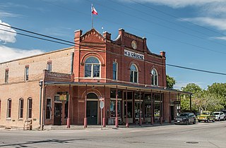
Cuero is a city in DeWitt County, Texas, United States. The population was 6,841 at the 2010 census. It is the county seat of DeWitt County. It is unofficially known as the "turkey capital of the world". In 2010, Cuero was named one of the "Coolest Small Towns in America" by Budget Travel magazine.

Gruene, New Braunfels, Texas former town and present-day district within New Braunfels, Texas, USA

Gruene is a former town in Comal County in the U.S. state of Texas. Once a significant cotton-producing community along the Guadalupe River, the town has now shifted its economy to one supported primarily by tourism. Gruene is now a district within the city limits of New Braunfels, and much of it was listed in the National Register of Historic Places on April 21, 1975. It is part of the San Antonio-New Braunfels Metropolitan Area.

Greenwood is an unincorporated community in Wise County, Texas, United States.

Huckabay, Texas Unincorporated community in Texas, United States

Huckabay is an unincorporated community located at the intersection of State Highway 108 and Farm Road 219, ten miles northwest of Stephenville in Erath County, Texas, United States. It had a population of approximately 3 in 1990.

Meyersville, Texas Unincorporated community in Texas, United States

Meyersville is an unincorporated community in DeWitt County, Texas, United States.

Lebanon was the name of two different communities that were founded in Texas in the 19th Century, neither of which exists today. The first was a town located in Collin County that had a post office designated as Lebanon, Texas, before it was relocated to Frisco, Texas. The second was a smaller unincorporated community located in Live Oak County of which only a cemetery remains today.

Carlton, Texas Unincorporated community in Texas, United States

Carlton is an unincorporated community located in Hamilton County in Central Texas. It lies in the northeastern part of the county and has an estimated population of 70.

Monthalia, Texas Unincorporated community in Texas, United States

Monthalia is a small unincorporated rural community in Gonzales County, Texas. The community had only 65 people as of the 2000 census. It is primarily home to livestock ranchers and has no schools or businesses. As a testament to its livestock ranching, Nolan Ryan Beef operates several ranches in the area raising cattle. It is located 14 miles (23 km) from Gonzales, Texas.

Thomaston, Texas Unincorporated community in Texas, United States

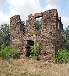
Thomaston is an unincorporated community in southeastern DeWitt County, Texas, United States. It lies along U.S. Route 87 southeast of the city of Cuero, the county seat of DeWitt County. Its elevation is 161 feet (49 m). Although Thomaston is unincorporated, it has a post office, with the ZIP code of 77989.

Flomot is an unincorporated community in Motley County, Texas, United States. According to the Handbook of Texas, the community had an estimated population of 181 in 2000.

Comyn is an unincorporated community located in Comanche County in Central Texas. Comyn is located in the east-northeastern part of the county along Farm-to-Market (FM) 1496 and the Fort Worth and Western Railroad.

Royston is a ghost town in northeastern Fisher County, Texas, United States, 10 miles (16 km) northeast of Roby. Historical Marker at Royston site: It was founded in 1907, and had a population of 500 in 1909. That figure declined to 75 by 1940, 30 in 1980 and 1990, and no figures were available by 2000. Royston Townsite - The town of Royston came into existence in 1906, when the Texas Central Railroad built a line through this area. In addition to the railroad depot, homes and businesses were soon established in the new town. The Royston Post Office was established in 1907. Businesses included a 30-room hotel, the "Royston Record" weekly newspaper, the Royston Mercantile Company, the Royston State Bank, a cotton gin, tin shop, grocery and hardware store, drug store, restaurant, and two lumberyards. A public school was in operation until 1947, when it was consolidated with McCaulley School. Churches in the town included Methodist, Baptist, and Pentecostal. The center of a rich agricultural area, Royston's economic base was broadened after the discovery of oil in the area in 1928. The railroad continued both freight and passenger service until 1972, and Royston was an important supply center for the surrounding agricultural area for a number of years. The town of Royston gradually declined, and the rails were removed by the railroad company. This site marks the approximate southern boundary of the town square. Now a ghost town, it is nevertheless an important part of Fisher County history.

Benton City, Texas Ghost Town in Texas, United States of America

Benton City is a ghost town in Atascosa County, Texas, United States, sometimes also called Benton, located on Benton City Road along Atascosa Creek, 3 miles east of present-day Lytle, 27 miles southwest of San Antonio.

Aurora Estrada Orozco was a Mexican American community leader and writer.

Cuthbert, Texas Ghost Town in Texas, United States

Cuthbert is a ghost town in Mitchell County, Texas, United States. Cuthbert was established in 1890 when the founder D. T. Bozeman built a wagonyard and store. The community and post office were named for Thomas Cuthbertson, a family friend of the Bozemans. By the early 1920s, Cuthbert had a church, two stores, a blacksmith shop, a cotton gin, telephone office, and a school. Today, only a cemetery and a few scattered farms remain.

Polonia was a small rural community located in northwest Caldwell County. The ghost town is 6 miles northwest of Lockhart, Texas.

Gasoline is a ghost town in Briscoe County, Texas.

String Prairie is an unincorporated community in Bastrop County, Texas, United States. Located on Texas State Highway 304, the town is 5 miles (8.0 km) southwest of Rosanky and 45 miles (72 km) southeast of Austin.

Hills Prairie, or Hill's Prairie, is an unincorporated community in Bastrop County, Texas, United States. It is located off Farm to Market Road 304, eight miles southeast of the town of Bastrop, 8 miles northwest of Smithville and 40 miles southeast of Austin.

References

  1. 1 2 U.S. Geological Survey Geographic Names Information System: Cheapside
  2. 1 2 3 4 5 6 7 8 9 Fly, W. Lamar (June 12, 2010). "Cheapside, Tx". Texas State Historical Association.
  3. Moyer, Armond; Moyer, Winifred (1958). The origins of unusual place-names. Keystone Pub. Associates. p. 21.
  4. 1 2 3 4 5 6 7 Racine, Marty (July 22, 2001). "Last Days of Cheapside: A Few Members of Town's Former Populace Keep It Alive". Houston Chronicle.
  5. "Ghost Town Between Cuero and Gonzales". Victoria Advocate. June 21, 2012.
  6. "Keyes Fawcett Carson". Victoria Advocate. November 28, 2007.