Chebucto Head

Last updated
Canada Nova Scotia location map 2.svg
Red pog.svg
Chebucto Head in Nova Scotia

Chebucto Head is a Canadian headland on Nova Scotia's Chebucto Peninsula located within the community of Duncan's Cove.

Contents

Chebucto Head forms the most easterly point on the peninsula and is used to define the southwestern limit of Halifax Harbour; historically known to the Mi'kmaq Nation as "Jipugtug", [1] [2] (anglicised as "Chebucto") meaning "the biggest harbour", [3] [4] [5] or simply, "the big harbour". A line drawn northeast from Chebucto Head to Pennant Point defines the southern geographic limit of the harbour. The actual legal limit of the harbour is located further inland to the north of this line.

Lighthouse

Chebucto Head lighthouse Chebucto Head Lighthouse (23238949363).jpg
Chebucto Head lighthouse

The first lighthouse at Chebucto Head was built in 1872 with a steam foghorn just below it. It was replaced by a second tower in 1928. This tower was demolished in 1940 and a new lighthouse and combined keeper's dwelling was built several hundred metres to the north to make way for a gun battery. In 1967 the light was moved from the house to the a new concrete tower which still stands today. [6] The house remained the keeper's dwelling until the light was destaffed in the 1990s. The house fell prey to repeated vandalism after the Canadian Coast Guard (CCG) cancelled the lease of the tenants who lived in and looked after the house. The plight of the lighthouse helped to inspire the Nova Scotia Lighthouse Preservation Society to push for the Heritage Lighthouse Protection Act, a campaign that was launched at the Chebucto Head lighthouse on March 11, 1999. [7] The house was destroyed by a suspicious fire on March 25, 2004. The Chebucto Head Lighthouse Society, a group formed to try to save the lighthouse continues to work to keep the site preserved and open to the public. [8]

Chebucto Head was used by the CCG as the control centre for the vessel traffic service or VTS that controlled vessel movements in Halifax Harbour until the 1980s when a new control centre was opened at Shannon Hill, above the Bedford Institute of Oceanography in Dartmouth. It continues as a Remote Aids to Navigation Station.

Chebucto Head inspired the name of the large harbour tug Point Chebucto , built at Halifax Shipyard in 1992.

Gun battery

During World War II, Halifax Harbour was the primary fast convoy departure and arrival point in eastern North America. The Royal Canadian Artillery operated a searchlight and coastal gun battery at Chebucto Head as part of "Fortress Halifax" as a means of providing an integrated defence for the port. The Chebucto Head battery was the key outer battery of the western side of harbour defending it from possible attacks by German U-boats or surface raiders. The fortified battery was armed with three Elswick 6 in (150 mm) naval guns with associated searchlight, director tower, generators, a long-range optical rangefinder and by 1943 a radar artillery control unit. The battery was decommissioned in the early 1950s but many bunkers remain, now privately owned.

On 16 April 1945, HMCS Esquimalt, a minesweeper, was torpedoed and sunk off Chebucto Head by U-190, becoming the last Royal Canadian Navy warship lost to enemy action in World War II. [9]

Related Research Articles

Citadel Hill (Fort George)

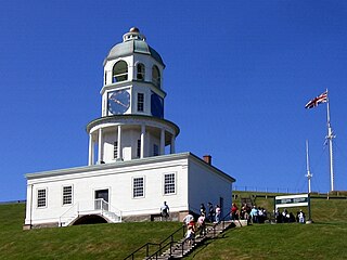
Citadel Hill is a hill that is a National Historic Site in Halifax, Nova Scotia, Canada. Four fortifications have been constructed on Citadel Hill since the city was founded by the English in 1749, and were referred to as Fort George—but only the third fort was officially named Fort George. According to General Orders of October 20, 1798, it was named after King George III. The first two and the fourth and current fort, were officially called the Halifax Citadel. The last is a concrete star fort.

Point Pleasant Park Park in Halifax, Nova Scotia

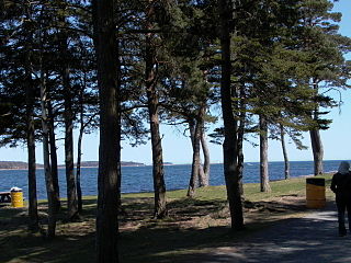
Point Pleasant Park is a large, mainly forested municipal park at the southern tip of the Halifax peninsula. It once hosted several artillery batteries, and still contains the Prince of Wales Tower - the oldest Martello tower in North America (1796). The park is a popular recreational spot for Haligonians, as it hosts forest walks and affords views across the harbour and out toward the Atlantic.

Halifax Harbour Harbour in Canada

Halifax Harbour is a large natural harbour on the Atlantic coast of Nova Scotia, Canada, located in the Halifax Regional Municipality.

History of Halifax (former city) Urban Community in Nova Scotia, Canada

Halifax, Nova Scotia, was originally inhabited by the Mi'kmaq. The first European settlers to arrive in the future Halifax region were French, in the early 1600s, establishing the colony of Acadia. The British settled Halifax in 1749, which sparked Father Le Loutre's War. To guard against Mi'kmaw, Acadian, and French attacks on the new Protestant settlements, British fortifications were erected in Halifax (1749), Bedford (1749), Dartmouth (1750), and Lawrencetown (1754). St. Margaret's Bay was first settled by French-speaking Foreign Protestants at French Village, Nova Scotia, who migrated from Lunenburg, Nova Scotia, during the American Revolution. All of these regions were amalgamated into the Halifax Regional Municipality (HRM) in 1996. While all of the regions of HRM developed separately over the last 250 years, their histories have also been intertwined.

McNabs Island

McNabs Island is the largest island in Halifax Harbour located in Halifax Regional Municipality, Nova Scotia, Canada. It played a major role in defending Halifax Harbour and is now a provincial park. The island was settled by Britons in the 1750s and later by Peter McNab, and McNab family members lived on the island until 1934.

Duncans Cove, Nova Scotia

Duncan's Cove is a small rural community on the Chebucto Peninsula in the Halifax Regional Municipality on the shore of the Atlantic Ocean on the Ketch Harbour Road, 19 kilometers from Halifax. The community is located beside Chebucto Head, the prominent coastal headland.

Dartmouth founded in 1750, is a Metropolitan Area and former city in the Canadian province of Nova Scotia.

Chebucto Community Net

The Chebucto Community Net (CCN) is a Canadian FreeNet operating in Nova Scotia's Halifax Regional Municipality (HRM). It is registered as a non-profit society under Nova Scotia's Registry of Joint Stocks using the name Chebucto Community Net Society. The name "Chebucto" comes from the local l'nu word for Halifax Harbour meaning "big water".

Sambro Island Light

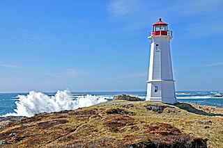
Sambro Island Lighthouse is a landfall lighthouse located at the entrance to Halifax Harbour, Nova Scotia, on an island near the community of Sambro in the Halifax Regional Municipality. It is the oldest surviving lighthouse in North America and its construction is a National Historic Event.

HMCS <i>Esquimalt</i>

HMCS Esquimalt was a Bangor-class minesweeper that served in the Royal Canadian Navy during the Second World War. She saw service in the Battle of the Atlantic and in the Battle of the St. Lawrence. She was sunk in 1945, the last Canadian warship to suffer that fate. She was named for Esquimalt, British Columbia.

Chebucto may refer to:

Halifax Shipyard

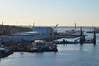
The Halifax Shipyard Limited is a Canadian shipbuilding company located in Halifax, Nova Scotia.

CFAV <i>Firebird</i> (YTR 561)

CFAV Firebird is a Fire-class fireboat in the Royal Canadian Navy designed by Robert Allan Ltd.. Firebird is based in CFB Halifax, in Halifax, Nova Scotia. Her sister ship CFAV Firebrand is based in CFB Esquimalt.

Kitano was a Japanese container ship. She was delivered in Japan in 1990 to Japanese container line NYK and scrapped in China in November 2011.

CCGS <i>Sambro</i>

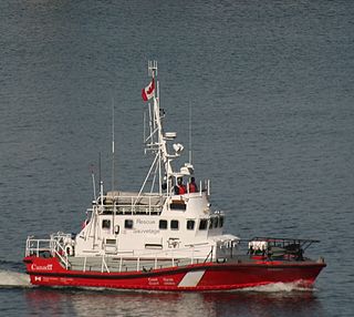
CCGS Sambro is a Canadian Coast Guard motor lifeboat homeported in Sambro, Nova Scotia.

Louisbourg Lighthouse

Louisbourg Lighthouse is an active Canadian lighthouse in Louisbourg, Nova Scotia. The current tower is the fourth in a series of lighthouses that have been built on the site, the earliest was the first lighthouse in Canada.

CCGS Earl Grey is a Samuel Risley-class light icebreaker and buoy tender in the Canadian Coast Guard. Constructed in 1986, the vessel serves a variety of roles, including light ice-breaking and buoy tending, as well as being strengthened for navigation in ice to perform tasking along the shores off the Atlantic coast of Canada. Like her sister ship, CCGS Samuel Risley, she carries a large and powerful crane on her long low afterdeck for manipulating buoys. Earl Grey is the second icebreaker in Canadian service to carry the name.

Tufts Cove, Nova Scotia Neighbourhood in Halifax Regional Municipality, Nova Scotia, Canada

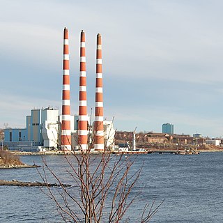
Tufts Cove is an urban neighbourhood in the Dartmouth area of Halifax, Nova Scotia, Canada. It is situated on the eastern shore of Halifax Harbour in the North End of Dartmouth. The neighbourhood boundaries of Tufts Cove are approximately from Albro Lake Road in the south to Highway 111 in the north, and from Victoria Road in the east with the harbour to the west.

Cape dOr

Cape d'Or is a headland located near Advocate, Cumberland County, on the Bay of Fundy coast of the Canadian province of Nova Scotia.

Outline of Nova Scotia Overview of and topical guide to Nova Scotia

The following outline is provided as an overview of and topical guide to Nova Scotia:

References

  1. "Mi'kmaq Online.org - Words, Pronunciation - Jipugtug (with audio clips)". MikmaqOnline.org. Retrieved 2009-08-07.CS1 maint: discouraged parameter (link)
  2. "MapleSquare.com - Halifax's History - Jipugtug (or Chebucto)". MapleSquare.com. Archived from the original on 2009-02-04. Retrieved 2009-08-07.CS1 maint: discouraged parameter (link)
  3. Paskal, Cleo (2006-06-10). "The Toronto Star - Harbouring a host of delights". TheStar.com. Retrieved 2009-08-07.CS1 maint: discouraged parameter (link)
  4. "Halifax Nova Scotia Canada Information - proudly presented by Kanada News". Nova-Scotia-Kanada.de. Retrieved 2009-08-07.CS1 maint: discouraged parameter (link)
  5. "DineAid.Com - Nova Scotia - Dartmouth - Chebucto, (the biggest harbour)". DineAid.com. Retrieved 2009-08-07.CS1 maint: discouraged parameter (link)
  6. ""Chebucto Head Lighthouse", Nova Scotia Lighthouse Preservation Society website". Archived from the original on 2010-10-05. Retrieved 2009-09-12.
  7. Graeme Hamilton "Lighthouse Yard Sale Coming, Group Fears" National Post March 12, 1999
  8. ""Chebucto Head Lighthouse Today", Nova Scotia Lighthouse Preservation Society website". Archived from the original on 2011-07-14. Retrieved 2009-09-12.
  9. Fisher, Robert C. (2011). "Within Sight of Shore – The Sinking of HMCS Esquimalt". CFB Esquimalt Naval & Military Museum. Archived from the original on 23 November 2013. Retrieved 30 May 2014.CS1 maint: discouraged parameter (link)

Coordinates: 44°30′03″N63°31′14″W / 44.50083°N 63.52056°W / 44.50083; -63.52056