
The Berber languages, also known as the Amazigh languages, are a branch of the Afroasiatic language family. They comprise a group of closely related languages spoken by Imazighen communities, who are indigenous to North Africa. The languages were traditionally written with the ancient Libyco-Berber script, which now exists in the form of Tifinagh.

Tifinagh is a script used to write the Berber languages. Tifinagh is descended from the ancient Libyco-Berber alphabet. The traditional Tifinagh, sometimes called Tuareg Tifinagh, is still favored by the Tuareg Berbers of the Sahara desert in southern Algeria, northeastern Mali, northern Niger and northern Burkina Faso for use writing the Tuareg Berber language. Neo-Tifinagh is an alphabet that was created in northern Algeria around the 1980s as an updated version. Neo-Tifinagh has been used since largely by Algerians and Moroccans for the symbolic promotion of the Berber language, while mainly using the Berber Latin alphabet in most publications. Neo-Tifinagh is often simply called "Tifinagh".
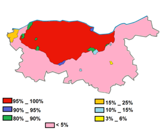
Kabyle or Kabylian is a Berber language spoken by the Kabyle people in the north and northeast of Algeria. It is spoken primarily in Kabylia, east of the capital Algiers and in Algiers itself, but also by various groups near Blida, such as the Beni Salah and Beni Bou Yaqob.(extinct?)

Guelma Province is a province (wilaya) in eastern Algeria. Its namesake is its seat and most populous municipality: Guelma.

Zaraï was a Berber, Carthaginian, and Roman town at the site of present-day Aïn Oulmene, Algeria. Under the Romans, it formed part of the province of Numidia.

Chlef is the capital of Chlef Province, Algeria. Located in the north of Algeria, 200 kilometres (120 mi) west of the capital, Algiers, it was founded in 1843, as Orléansville, on the ruins of Roman Castellum Tingitanum. In 1962, it was renamed al-Asnam, but after the devastating earthquake on October 10, 1980, it has borne its present name, Chlef, which is derived from the name of the Chelif River, the longest river in Algeria.

Bou Saada is a town and municipality in M'Sila Province, Algeria, situated 245 km south of Algiers. As Arena it was the site of a city and bishopric in Roman Africa, now a Catholic titular see. The municipal population was estimated at 134,000 in 2008.
Miliana is a commune in Aïn Defla Province in northwestern Algeria. It is the administrative center of the daïra, or district, of the same name. It is approximately 114 kilometres (71 mi) southwest of the Algerian capital, Algiers. The population was estimated at 44,201 in 2008. The town is located south of the Dahra Range, on the wooded southern flank of Mount Zaccar Rherbi, five kilometers north of the Chelif River, and overlooking the Zaccar plateau to the west.
Zuccabar was an ancient town in the Roman province of Mauretania Caesariensis. It is located in present-day Miliana, Algeria.
Shaqqa or Shakka is a Syrian town in As Suwayda Governorate in southern Syria, whose some 8,000 inhabitants are mainly Druze, descendants of those who migrated here from Lebanon in the 18th and 19th centuries.
Boumedfaa a town in northern Algeria.

Djinet, the classical Cissi, is a port town and commune in the Bordj Menaïel District of Boumerdès Province, Algeria, east of the mouth of the Isser River and around Cape Djinet. As of 2008, the population of the municipality is 21,966.

Bou-Nouh is a town and commune in Tizi Ouzou Province in northern Algeria.

Numidian was a language spoken in ancient Numidia, a territory covering much of northern Africa. Although the script in which it was written, the Libyco-Berber alphabet, has been almost fully deciphered and most characters have known values, the language has barely been deciphered and only a few words are known. Libyco-Berber inscriptions are attested from the 3rd century BC to the 3rd century AD. The language is scarcely attested and can be confidently identified only as belonging to the Afroasiatic family, although it was most likely part of the Berber languages, spoken at the start of the breakup of the Proto-Berber language.

Tiddis was a Roman city that depended on Cirta and a bishopric as "Tiddi", which remains a Latin Catholic titular see.
Mertoutek is a village in the commune of Idlès, in Tazrouk District, Tamanrasset Province, Algeria. It lies in the northern Hoggar Mountains on the eastern side of a wadi, 61 kilometres (38 mi) northwest of the town of Idlès and 158 kilometres (98 mi) north of Tamanrasset.

Djebba, also known as Thigibba Bure, is a town and an ancient archaeological site is located in Bājah, Tunisia. Djebba is an archaeological/prehistoric site in Tunisia located at latitude: 36°28'32.45" longitude: 9°4'53.54" in the Béja Governorate of northwestern Tunisia. The estimated terrain elevation above sea level is 355 metres located below the slopes of Djebel Gorra, 700 meters above sea level. Djebba also has a national park, which is the subject of a development project
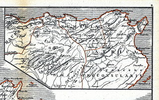
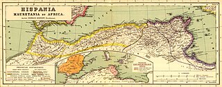
Numidia was a Roman province on the North African coast, comprising roughly the territory of north-east Algeria.

The Cirta steles are almost 1,000 Punic funerary steles found in Cirta in a cemetery located on a hill immediately south of the Salah Bey Viaduct.

The Libyco-Berber alphabet or the Libyc alphabet is an abjad writing system that was used during the first millennium BC by various Berber peoples of North Africa and the Canary Islands, to write ancient varieties of the Berber language like the Numidian language in ancient North Africa.


