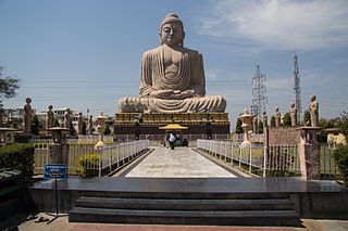
Bodh Gayā is a religious site and place of pilgrimage associated with the Mahabodhi Temple complex, situated in the Gaya district in the Indian state of Bihar. It is famous for being the place where Gautama Buddha is said to have attained enlightenment under what became known as the Bodhi Tree. Since antiquity, Bodh Gayā has remained the object of pilgrimage and veneration, for both Hindus and Buddhists. In particular, archaeological finds, including sculptures, show that the site was in use by Buddhists since the Mauryan period. Bodh Gayā and the nearby regions were invaded and destroyed in the 12th century CE by Muslim Turk armies, led by Delhi Sultanate's Qutb al-Din Aibak and Bakhtiyar Khilji.
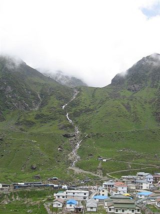
Kedarnath is a town and Nagar Panchayat in Rudraprayag district of Uttarakhand, India, known primarily for the Kedarnath Temple. It is approximately 86.5 kilometres from Rudraprayag, the district headquarters. Kedarnath is the most remote of the four Chota Char Dham pilgrimage sites. It is located in the Himalayas, about 3,583 m (11,755 ft) above sea level near the Chorabari Glacier, which is the source of the Mandakini River. The town is flanked by snow-capped peaks, most prominently the Kedarnath Mountain. The nearest road head is at Gaurikund about 16 km away. The town suffered extensive destruction during June 2013 from the Flash Floods caused by torrential rains in Uttarakhand state.

Tenkasi is a town and headquarters of the Tenkasi district in Indian state of Tamil Nadu.

Bhavani is a Municipality in Erode District, Tamil Nadu, India. It is located at the northern periphery of Erode City Municipal Corporation and is around 105 km (65 mi) from Coimbatore and 60 km (37 mi) from Tiruppur and Salem. Bhavani is also known as "Carpet City" as it is known for its carpet industry; blankets and carpets manufactured in the town are known as Bhavani Jamakkalam. As of 2011, the town covers an area of 2.17 square kilometres (0.84 sq mi) and has a population of 39,225. It is a grade II municipality.

Hinduism is the third largest religion in Australia consisting of more than 684,002 followers, making up 2.7% of the population as of the 2021 census. Hinduism is the fastest growing religion in Australia mostly through immigration. Hinduism is also one of the most youthful religions in Australia, with 34% and 66% of Hindus being under the age of 14 and 34, respectively.

Ariyalur district is an administrative district, one of the 38 districts in the state of Tamil Nadu in India. The district headquarters is located at Ariyalur. The district encompasses an area of 1,949.31 km2.
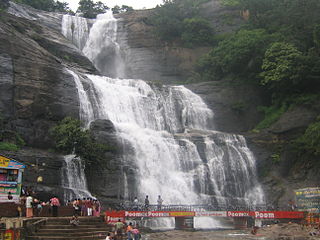
Courtallam is a panchayat town situated at a mean elevation of 160 m (520 ft) in the foothills of the Western Ghats in Tenkasi district of Tamil Nadu, India. The Coutrallam Falls on the Chittar River is a major tourist attraction.
Hinduism is the second largest religious affiliation in Pakistan after Islam. Though Hinduism was one of the dominant faiths in the region a few centuries ago, Hindus accounted for just 2.17% of Pakistan's population according to the 2023 Pakistani census. With the largest population concentration in eastern Sindh province, Umerkot district has the highest percentage of Hindu residents in the country at 54.6%, while Tharparkar district has the most Hindus in absolute numbers at 811,507. Hindus are also found in southern Punjab and in areas of Balochistan and Khyber Pakhtunkhwa.
Palani or Pazhani(Tamil:[paɻani]), is a town in Dindigul district of Tamil Nadu state in India. It is located about 54 kilometres (34 mi) west of Dindigul, 106 kilometres (66 mi) south-east of Coimbatore, 122 kilometres (76 mi) north-west of Madurai, 67 kilometres (42 mi) from Kodaikanal. The Palani Murugan Temple or Arulmigu Dhandayuthapani Swamy Temple, dedicated to Murugan is situated on a hill overlooking the town. The temple is visited by more than 7 million pilgrims each year. As of 2011, the town had a population of 70,467 and the Taluk had a population of 292,301 which makes it the second largest town in the district after Dindigul.
Devakottai is a first-grade municipality in the state of Tamil Nadu, India. Located in the Sivaganga district, the town is situated close to the Karaikudi, near Rameswaram National Highway Road (NH-210). It is one of the major cities comes under the Chettinad area with rich heritage of houses built with limestone called "Karai Veedu". This Region is one of the towns in Chettinad belt. The town is famous for its ancient temple Sri Meenakshi Sundareswarar temple also known as Nagara Sivan Kovil.
Puzhuthivakkam, commonly known as Ullagaram or Ullagaram–Puzhuthivakkam, is a southern neighbourhood of Chennai in Tamil Nadu, India. Puzhuthivakkam loosely translates to dust neighborhood. The neighbourhood is part of the Greater Chennai Corporation, following Chennai's expansion into Kanchipuram district. Puzhuthivakkam is located between the neighborhoods of Madipakkam, Adambakkam, Velachery, Pallikaranai, and Nanganallur. Puzhuthivakkam was initially developed in the late 1960s and early 1970s. Upon completion of the MRTS extension line, the neighborhood will be served by Puzhuthivakkam railway station. As of 2011, the town had a population of 53,322.
Ambasamudram is the principal town of the Ambasamudram taluk in Tirunelveli district in the state of Tamil Nadu, India. The entire taluk had a population of 392,226 as of 2001, with 42.5% classified as rural. The town of Ambasamudram had a population 35,645 as of 2011.
Khanapur known as Khanapura is a panchayat town in Belagavi district, Karnataka, India. It is about 26 km from Belagavi, the administrative capital of the district. The Khanapur Municipal Council governs the town. Khanapur is the headquarters for Khanapur taluk. The town is on the Belgaum-Panaji National Highway, NH 4A. Khanapur is well connected by train and road to important cities in Karnataka, Goa, and Maharashtra. Kannada is the official language.

Ramjibanpur is a city and a municipality in the Ghatal subdivision of the Paschim Medinipur district in the Indian state of West Bengal.
Sembakkam is a neighborhood in the city of Tambaram, situated within the Chennai Metropolitan Area, Tamil Nadu, India.
Valasaravakkam is a neighbourhood in the Chennai district of the Indian state of Tamil Nadu and a residential suburb of the city of Chennai. It is located in the Maduravoyal Taluk at a distance of approximately 15 kilometres from the Kilometer Zero stone. Valasaravakkam lies on the Arcot Road, one of Chennai's arterial roads. It is under the Maduravoyal election constituency. In October, 2011 Valasaravakkam Municipality ceased to exist and the area became part of Chennai Corporation as Ward Nos 149 and 152, Southern Region, Corporation of Chennai. As of 2011, the town had a population of 47,378. Famous Sivan temple is in Kesavardhini.

Virudhachalam, also called Vriddhachalam, is a Municipality and taluk headquarters in Cuddalore district in the Indian state of Tamil Nadu. The ancient name of this town is Thirumudhukundram. As per the 2011 census, the town had a population of 73,585 of which 37,066 are males while 36,519 are females. Population of children in the ages of 0-6 is 7735 which is 10.51 % of the total population. The Virudhagiriswarar temple dedicated to Lord Shiva is located in the heart of town. This is the 41st Sivan temple to be sung about in Thevāram and 9th Temple to be sung about in Nadunādu Moovar has sung hymns in praise of Lord Siva of this temple. The temple was constructed by one of the Chola Emperors. The famous Kolanjiappar Temple is located 3 km away from the town. Both of them are situated near Cuddalore - Salem highway in Virudhachalam. The temple has been mentioned in the travalogue Tirtha Prabandha written by Madhwa saint Vadiraja tirtharu in sixteenth century.
Periapalayam is a village about 40 km north of Chennai, in Tiruvallur district, Tamil Nadu State, India. The nearest Railway station is Thiruninravur.It is in Ellapuram block which stretches from east Thanakulam village, west Uthukottai, north Kosavanpettai and in the south up to Komakambedu village. It has one of the main routes to Andhra Pradesh.

Botad District is a is a district in the state of Gujarat, India.

Tiruvannamalai is a city, a spiritual, cultural, economic hub and also the administrative headquarters of Tiruvannamalai District in the Indian state of Tamil Nadu. The city is home to the renowned Annamalaiyar temple, Annamalai hill, Girivalam and the Karthigai Deepam festival and a prominent pilgrimage destination.

