Cheshire Farm Trail

Last updated

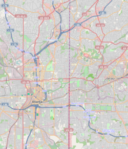
The Cheshire Farm Trail is a walking trail along the South Fork of Peachtree Creek in Atlanta. [1] [2] Ribbon cutting is scheduled for September 2014. [3]

Peachtree Creek

Peachtree Creek is a major stream in Atlanta. It flows for 7.5 miles (12.1 km) almost due west into the Chattahoochee River just south of Vinings.

Atlanta Capital of Georgia, United States

Atlanta is the capital of, and the most populous city in, the U.S. state of Georgia. With an estimated 2017 population of 486,290, it is also the 38th most-populous city in the United States. The city serves as the cultural and economic center of the Atlanta metropolitan area, home to 5.8 million people and the ninth-largest metropolitan area in the nation. Atlanta is the seat of Fulton County, the most populous county in Georgia. A small portion of the city extends eastward into neighboring DeKalb County.

The trail, costing ca. 1 million US dollars, was funded by Georgia Department of Transportation to appease local residents who were not happy about construction of a flyover for the Georgia 400/I-85 interchange. The trail is named for the Cheshire family, Atlanta pioneers. [4] Two brothers of the family had homesteads across the creek from each other. The bridge they built gives name to the local thoroughfare Cheshire Bridge Road [2]

Interstate 85 (I-85) is a major Interstate Highway that travels northeast-to-southwest in the U.S. state of Georgia. It enters the state at the Alabama state line near West Point, and Lanett, Alabama, traveling through the Atlanta metropolitan area and to the South Carolina state line, where it crosses the Savannah River near Lake Hartwell. I-85 connects northern Georgia with Montgomery, Alabama, to the southwest, and with South Carolina, North Carolina, and Virginia to the northeast. Within Georgia, I-85 is also designated as the unsigned State Route 403 (SR 403).

Cheshire Bridge Road is a mainly north-south thoroughfare of Atlanta, Georgia, USA< traversing the Morningside-Lenox Park and Lindridge-Martin Manor neighborhoods from Piedmont Avenue to Buford Highway just north of Interstate 85.

Related Research Articles

North Druid Hills, Georgia Community and Census-designated place in Georgia, United States

North Druid Hills, also known as Briarcliff, is an unincorporated community and census-designated place in DeKalb County, Georgia, United States. The population was 18,947 at the 2010 census. The center of the area is the intersection of Briarcliff and North Druid Hills Roads.

Georgia State Route 400 highway in Georgia

Georgia State Route 400 is a freeway and state highway in the U.S. state of Georgia serving parts of Metro Atlanta. It is concurrent with U.S. Route 19 (US 19) from exit 4 until its terminus south-southeast of Dahlonega, linking the city of Atlanta to its north-central suburbs and exurbs. SR 400 travels from the Lindbergh neighborhood in the Buckhead district of Atlanta, at Interstate 85 (I-85), to just south-southeast of Dahlonega. Like the Interstate highways, it is a limited-access road, but unlike the interstates, the exit numbers are not mileage-based, they are sequential. Once SR 400 passes exit 17 (SR 306), it changes from a limited-access freeway into an at-grade divided highway with traffic lights, but still with a high speed limit of 65 miles per hour (105 km/h), and ends at the J.B. Jones Intersection at SR 60/SR 115 in Lumpkin County.

Peachtree Street main street of Atlanta, Georgia, USA

Peachtree Street is one of several major streets running through the city of Atlanta. Beginning at Five Points in downtown Atlanta, it runs North through Midtown; a few blocks after entering into Buckhead, the name changes to Peachtree Road at Palisades Road. Much of the city's historic and noteworthy architecture is located along the street, and it is often used for annual parades,, as well as one-time parades celebrating events such as the 100th anniversary of Coca-Cola in 1986 and the Atlanta Braves' 1995 World Series victory.

Buckhead District of Atlanta

Buckhead is an affluent uptown commercial and residential district of Atlanta, Georgia, comprising approximately the northernmost fifth of the city.

Georgia State Route 141 highway in Georgia

State Route 141 (SR 141) is a 28.0-mile-long (45.1 km) state highway that runs southwest-to-northeast in the northwest part of the U.S. state of Georgia. It connects the Buckhead area of Atlanta with Cumming. Its routing exists within portions of Fulton, DeKalb, Gwinnett, Forsyth counties.

Standing Peachtree was a Creek Indian village and the closest Indian settlement to what is now the Buckhead area of Atlanta, Georgia. It was located where Peachtree Creek flows into the Chattahoochee River, in today's Paces neighborhood. It was located in the borderlands of the Cherokee and Creek nations. It is referred to in several documents dating as far back as 1762.

There were several historic mills around the metro Atlanta area, for which many of its current-day roads are still named. Most of the mills date back to the 1820s and 1830s, and were built along the area's many streams. The locations of many of these mills are shown on a map of 1875 showing U. S. military operations around Atlanta in 1864. This map is now located in the U. S. Library of Congress but can be seen on the webpage linked here.

Through much of the 19th century, Pace's Ferry was an important ferry across the Chattahoochee River near Atlanta. Started in the early 1830s near Peachtree Creek, it was run by Hardy Pace, one of the city's founders. It was an important transportation link to northwestern Georgia, especially prior to the construction of the State Road to Chattanooga.

Brookhaven, Georgia City in Georgia, United States

Brookhaven is a city in the northeastern suburbs of Atlanta and is located in western DeKalb County, Georgia, United States, directly northeast of Atlanta. On July 31, 2012, Brookhaven was approved in a referendum to become DeKalb County's 11th city. Incorporation officially took place on December 17, 2012, on which date municipal operations commenced. With a population of around 54,169, it is the largest city in DeKalb County. The new city stretches over 12 square miles (31 km2).

Arts Center station (MARTA) underground metro station on the Red and Gold lines of the Metropolitan Atlanta Rapid Transit Authority (MARTA) rail system

Arts Center station is a train station in Atlanta, Georgia, serving the Red and Gold lines of the Metropolitan Atlanta Rapid Transit Authority (MARTA) rail system. It is the northernmost of three MARTA stations that serve Midtown Atlanta, the others being Midtown and North Avenue.

Peachtree Corners, Georgia City in Georgia, United States

Peachtree Corners is a city in western Gwinnett County, Georgia, United States. It is a northern suburb of Atlanta, and is the largest city in Gwinnett County, with an estimated population of 42,773 in 2016. The city, bordered to the north and west by the Chattahoochee River, is located east of Dunwoody and south of Johns Creek. Peachtree Corners is the only one of Atlanta's northern suburbs that was developed as a planned community.

Morningside/Lenox Park human settlement in United States of America

Morningside/Lenox Park is an intown neighborhood in Atlanta, Georgia founded in 1923. It is located north of Virginia-Highland, east of Ansley Park and west of Druid Hills. Approximately 3,500 households comprise the neighborhood that includes the original subdivisions of Morningside, Lenox Park, University Park, Noble Park, Johnson Estates and Hylan Park.

There were several historic bridges around the metro Atlanta, Georgia area, for which many of its current-day roads are named. Many of them originated as ferries, dating back to the 1820s and 1830s, and carrying travelers across the Chattahoochee River and several other smaller rivers. Several were also covered bridges, a very few of which remain as historic sites.

U.S. Route 19 in Georgia highway in Georgia

U.S. Route 19 (US 19) is a 349-mile-long (562 km) U.S. Highway in the U.S. state of Georgia. It travels from the Florida state line south-southeast of Thomasville, Georgia, through Albany and Atlanta, to the North Carolina state line at a point north of Lake Nottely.

Lindridge/Martin Manor is an intown neighborhood of Atlanta, Georgia. It consists mostly of the single-family homes located off Lindbergh Drive in between I-85 and Cheshire Bridge Road. In addition, it includes a small commercial area of three streets west of I-85 bounded by Peachtree Creek, Piedmont Road and the Southern railroad. The neighborhood's boundaries are I-85 on the northwest, Morningside-Lenox Park on the south, and North Druid Hills in unincorporated DeKalb County, Georgia on the east.

Lindbergh, Atlanta human settlement in United States of America

Lindbergh, officially Lindbergh/Morosgo, is a neighborhood in the Buckhead district of Atlanta, Georgia. Most of the neighborhood consists of multi-use development combining retail, office and residential space.

Peachtree Hills is a neighborhood within the Buckhead district of Atlanta, Georgia. It consists primarily of residential buildings, but restaurants, retail, and mixed use buildings are scattered throughout the neighborhood. Peachtree Battle Shopping Center is located within the borders of Peachtree Hills.

References