
Gulmi District, a part of Lumbini Province, is one of the seventy-seven districts of Nepal. The district, with Tamghas as its headquarters, covers an area of 1,149 km2 (444 sq mi), had a population of 296,654 in 2001, 280,160 in 2011 and 268,597 in 2016.

Kaski District (Nepali: कास्की जिल्ला[kaski], a part of Gandaki Province, is one of the seventy-seven districts of Nepal. The name is disambiguated from Kaskikot, the ancient Kaski Kingdom.

Mahottari District, a part of Province No. 2, is one of the seventy-seven districts of Nepal. The district, with Jaleshwar as its district headquarters, covers an area of 1,002 km2 (387 sq mi) and had a population of 553,481 in 2001 and 627,580 in 2011. Its headquarters is located in Jaleshwar, a neighbouring town of the historical city of Janakpur. The name Jaleshwar means the 'God in Water'. One can find a famous temple of Lord Shiva in Water there. Jaleshwar lies at a few kilometres distance from the Nepal-India border and has a majority Maithili population. In Janakpur zone there are two districts ; mahottari and Dhanusha and both are in a distance of 1 hour.

Palpa District (Nepali: पाल्पा जिल्लाListen , a part of Lumbini Province, is one of the seventy-seven districts of Nepal, a landlocked country of South Asia. The district, with Tansen as its headquarters, covers an area of 1,373 km2 and has a population of 261,180.

Rupandehi District, a part of Lumbini Province, is one of the seventy-seven districts of Nepal and covers an area of 1,360 km2 (530 sq mi). The district headquarter is Bhairahawa. As per the national census 2011, the population of Rupandehi was 880,196.

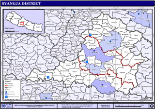
Syangja District, a part of Gandaki Province, is one of the seventy-seven districts of Nepal. The district, with Syangja bazaar as its district headquarters, covers an area of 1,164 km2 (449 sq mi) and had a population of 289,148 It lies in the hilly region at an altitude ranging from about 300 meters along the banks of Kaligandaki river up to a couple of thousands meters above the sea level. It lies at about latitude 28°4'60 North and longitude 83°52'0 East.

Dhulikhel is a municipality in Kavrepalanchok District of Nepal. Two major highway B.P. Highway and Arniko Highway passes through Dhulikhel. Araniko Highway connects Kathmandu, Nepal's capital city with Tibet's border town of Kodari. Dhulikhel is located at the Eastern rim of Kathmandu Valley, south of the Himalayas at 1550m above sea level and is situated 30 km southeast of Kathmandu and 74 km southwest of Kodari. The Majority of people in dhulikhel is Newars, and Brahmin, Chhettri, Tamang and Dalit are also living in outer area of the town. Drinking water in Dhulikhel is some of the best water in Nepal. It was made with the help of the German NGO, German Technical Cooperation.

Waling Municipality, the heart of Syangja, is a small valley covered with hills formed on 27 January 1997 by merging of the then three VDCs namely Waling, Dhanubase and Pekhubaaghkhor. It is a town and municipality in the western hilly region of Nepal. It is in the Aadhikhola valley in Syangja District, Gandaki Zone of Nepal. Waling will be the first municipality to have houses all coloured with pink and will be named as Pink City. Waling has grabbed an award for the best municipality of the country.
Tokha Chandeshwari is a village and former Village Development Committee that is now part of Tokha Municipality in Kathmandu District in Province No. 3 of central Nepal. At the time of the 2011 Nepal census it had a population of 3,961. Tokha Chandeshwari now is part of Tokha municipality.

Biruwa Archale is a village development committee in Syangja District in the Gandaki Zone of central Nepal. At the time of the 2011 Nepal census it had a population of 2860 people living in 674 individual households. ward no. 1 Dara/Besardada village is 100% Gurung Village. While the other Ward No. 2 Shree Danda and the remaining Ward No. 3-9 consists of Magar, Chhetri and Brahmins.
Nibuwakharka is a village development committee in Syangja District, Gandaki Zone, Nepal. At the time of the 2011 Nepal census it had a population of 3,875 living in 790 individual households. There are major 9 ward no/villages in this VDC. Magar and Bramhin are the major castes living in this village.

Sankhar is a village development committee in Chapakot Municipality of Syangja District in Gandaki Province of central Nepal. At the time of the 2011 Nepal census it had a population of 4,630 people residing in 1,055 individual households. Majuwa, Mohami, Bhattarai Danda, Keladighat, Patasar, Panglung, Salghari, Manechaur, Khasa Bankata, Pipalchhap, Khardi, Samakot, Tangle, Gahate, Ajingare, and Hadiban are major villages in Sankhar.
Tindobate is a village development committee in Syangja District in the Gandaki Zone of central Nepal. 9 km of the Siddartha Highway lies in this VDC. Karadi and Bayatatri are two small town of Tindobate on the Siddhartha Highway. At the time of the 2011 Nepal census it had a population of 4596 people living in 994 individual households.
Lalbandi is a Municipality in Sarlahi District in the Janakpur Zone of south-eastern Nepal. The municipality was established on 18 May 2014 by merging the existing Parwanipur VDC, Netragung vdc, Jabdi, Lalbandi and Pattharkot VDCs. At the time of the 2011 Nepal Census, it had a population of 59,395 people living in 3,295 individual households. There are 17 wards in this municipality. It is the largest municipality in Sarlahi district. The office of this municipality is in ward no.6 Located in the Lalbandi. Lalbandi Bazar, located on the East West Mahendra highway, is one of the main trading areas within the municipal area. Bordering East Ishwarpur Municipality, West Hariwan and Haripur Municipality, North Sindhuli District and bordering Haripur and Ishwarpur in the south, Lalbandi Bazar is the main trading site of the district.

Dudhauli is a municipality of the Sindhuli District in the Janakpur Zone of south-eastern Nepal.

Rampur is a municipality in Palpa District in Lumbini Province of West southern Nepal. According to hindu mythology, Maharishi Vasistha taught Yogavasistha to lord Rama in the cave of Rampur. Rampur is 65 km northeast from the headquarter city Tansen. The valley is bounded by Syangja District in the north, Tanahun District in the northeast, and Nawalparasi District in the east. The popular religious river Kaligandaki disconnects the boundary in the northern part.

Letang, "लेटाङ " is a Municipality in Morang District in the Province No. 1 of south-eastern Nepal. It was formed by merging the existing Village Development Committees of Letang, Jante, Warrangi and Bhogateni.
Edited by ABHASH
Sunwal is a municipality in Parasi District. It lies in Western Development Region, Lumbini Zone. It was announced as a municipality on 2011 combining two neighboring Village Development Committees; Sunwal and Swathi; of the district. It is the urban core of a rapidly growing urban agglomerate in Nepal and it belongs to the State no.5 under new constitution.

Kawasoti (Nepali: कावासोती) is a municipality in Nawalpur District, Gandaki Province, Nepal. It is 31 km (19 mi) west of Bharatpur and 85 km (53 mi) east of Butwal, approximately on the middle of Mahendra Highway. The Naryani River flows south of it, and the Mahabharat Range is north of it.
Pindikhola was a village development committee in Syangja District in the Gandaki Zone of central Nepal. At the time of the 2011 Nepal census it had a population of 4,956 people living in 1,119 individual households.

