Chiaramonte Gulfi

Last updated
Chiaramonte Gulfi
Ciaramunti
Comune di Chiaramonte Gulfi
Chiaramonte Gulfi view.jpg
View of Chiaramonte Gulfi from Mount Arcibessi.
Chiaramonte Gulfi-Stemma.png
Location of Chiaramonte Gulfi
Chiaramonte Gulfi
Italy provincial location map 2016.svg
Red pog.svg
Chiaramonte Gulfi
Location of Chiaramonte Gulfi in Italy
Italy Sicily location map IT.svg
Red pog.svg
Chiaramonte Gulfi
Chiaramonte Gulfi (Sicily)
Coordinates: 37°01′52″N14°42′10″E / 37.03111°N 14.70278°E / 37.03111; 14.70278
Country Italy
Region Sicily
Province Ragusa (RG)
Frazioni Piano dell'Acqua, Roccazzo, Sperlinga
Government
  MayorMario Cutello
Area
[1]
  Total126 km2 (49 sq mi)
Elevation
668 m (2,192 ft)
Population
 (30 November 2017) [2]
  Total8,137
  Density65/km2 (170/sq mi)
Demonym Chiaramontani
Time zone UTC+1 (CET)
  Summer (DST) UTC+2 (CEST)
Postal code
97012
Dialing code 0932
Patron saintSan Vito and La Madonna di Gulfi
Saint day15 June
Website Official website
Sanctuary of Gulfi. Santuario di Gulfi.jpg
Sanctuary of Gulfi.
The Northern Gate called Arco dell'Annunziata. Arcoa.jpg
The Northern Gate called Arco dell'Annunziata.

Chiaramonte Gulfi (Sicilian: Ciaramunti) is a town and comune in the province of Ragusa, Sicily, southern Italy.

Contents

Geography

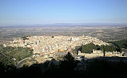
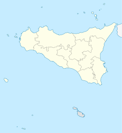
Chiaramonte Gulfi is located on a hill-top 15 kilometres (9 mi) north of Ragusa at an altitude of 668 metres (2,192 ft) above sea level. The highest point is on Monte Arcibessi at 907 metres (2,976 ft). Its hamlets (frazioni) are the villages of Piano dell'Acqua, Roccazzo and Sperlinga.

The church of San Vito. Church of Santo Vito, Chiaramonte Gulfi.jpg
The church of San Vito.

The town is also called Balcony of Sicily for its panoramic position, with views over the Valley of the Ippari and its towns (Comiso, Vittoria, Acate) and all the way to the Mediterranean Sea if looking south, as far as Mount Etna in direction north and to the Erean Mountains with Caltagirone if looking west.

History

In the area numerous archeological sites from the Bronze Age and Iron Age have been found, as well as ruins dating to the Greek Archaic era and Hellenistic era. Also Roman, Byzantine and medieval testimonies can be found.

The city was founded by the Greek colonists from Syracuse in the 7th century BC with the name of Akrillai . Destroyed a first time by the Carthaginians in 406 BC, it was rebuilt during the Timoleonic era. In 213 BC Akrillai was the location of battle in which the Syracusan army, led by Hippokrates, was defeated by the Roman army led by the Consul Marcus Claudius Marcellus. Thenceforth the city of Akrillai was part of the Roman province of Sicily, its name being changed to Acrillae. [3]

The ancient town was destroyed a second time by the Arabs under Asad ibn al-Furat in 827 AD, and the name Acrillae disappeared. The rebuilt centre was known by the Arabic name of Gulfi, [4] which means "pleasurable place".

In 1299 Gulfi was besieged and captured by Roger de Lauria for the Angevines during the War of the Vesper; Manfredi Chiaramonte, who had been named Count of Modica by the Aragonese King Frederick III, moved the survivors to an upper location, called Baglio, which he fortified and protected with a castle.

In 1593 the town had grown outside the walls and had 5,711 inhabitants. It was nearly entirely destroyed by an earthquake in 1693, and was subsequently rebuilt.

Main sights

Economy

The local economy is based on agriculture, mainly olives, vineyards, vegetables, almonds and the raising of pigs and cattle. The area of Chiaramonte is also known for its olive oil that gained the Protected Geographical Status.

See also

Twin towns — sister cities

Related Research Articles

<span class="mw-page-title-main">Syracuse, Sicily</span> City in Sicily, Italy

Syracuse is a historic city on the Italian island of Sicily, the capital of the Italian province of Syracuse. The city is notable for its rich Greek and Roman history, culture, amphitheatres, architecture, and as the birthplace and home of the pre-eminent mathematician and engineer Archimedes. This 2,700-year-old city played a key role in ancient times, when it was one of the major powers of the Mediterranean world. Syracuse is located in the southeast corner of the island of Sicily, next to the Gulf of Syracuse beside the Ionian Sea. It is situated in a drastic rise of land with 2,000 metres (6,600 ft) depths being close to the city offshore although the city itself is generally not so hilly in comparison.

<span class="mw-page-title-main">Province of Ragusa</span> Province of Italy

The province of Ragusa was a province in the autonomous region of Sicily, Italy, located in the southeast of the island. Following the abolition of the Sicilian provinces, it was replaced in 2015 by the free municipal consortium of Ragusa. Its capital is the city of Ragusa, Sicily, which is the most southerly provincial capital in Italy.

<span class="mw-page-title-main">Ragusa, Sicily</span> City in Sicily, Italy

Ragusa is a city and comune in southern Italy. It is the capital of the province of Ragusa, on the island of Sicily, with 73,288 inhabitants in 2016. It is built on a wide limestone hill between two deep valleys, Cava San Leonardo and Cava Santa Domenica. Together with seven other cities in the Val di Noto, it is part of a UNESCO World Heritage Site.

<span class="mw-page-title-main">Gela</span> Comune in Sicily, Italy

Gela is a city and comune (municipality) in the Autonomous Region of Sicily, Italy; in terms of area and population, it is the largest municipality on the southern coast of Sicily. Gela is part of the Province of Caltanissetta and is one of the few comuni in Italy with a population and area that exceed those of the provincial capital.

<span class="mw-page-title-main">Chiaramonte</span>

The Chiaramonte are a noble family of Sicily. They became the most powerful and wealthy family in Sicily. In the 13th century the marriage of Manfredi Chiaramonte to Isabella Mosca, united the two Sicilian counties of Modica and Ragusa. Around 1307–1320, the couple built the family seat, the Palazzo Chiaramonte, in Palermo.

<span class="mw-page-title-main">Modica</span> Comune in Sicily, Italy

Modica is a city and comune of 54,456 inhabitants in the Province of Ragusa, Sicily, southern Italy. The city is situated in the Hyblaean Mountains.

<span class="mw-page-title-main">Scicli</span> Comune in Sicily, Italy

Scicli is a town and municipality in the Province of Ragusa in the south east of Sicily, southern Italy. It is 25 kilometres (16 mi) from Ragusa, and 188 kilometres (117 mi) from Palermo, and has a population (2017) of 27,051. Alongside seven other cities in the Val di Noto, it has been listed as one of UNESCO's World Heritage Sites.

<span class="mw-page-title-main">Licodia Eubea</span> Comune in Sicily, Italy

Licodia Eubea is a town and comune in the Metropolitan City of Catania, on the island of Sicily, southern Italy. It is bounded by the comuni of Caltagirone, Chiaramonte Gulfi, Giarratana, Grammichele, Mazzarrone, Mineo, Monterosso Almo and Vizzini. It rises over an internal hilly area, 630 metres (2,070 ft) above sea level.

<span class="mw-page-title-main">Comiso</span> Comune in Sicily, Italy

Comiso is a comune of the Province of Ragusa, Sicily, Southern Italy. As of 2017, its population was 29,857.

<span class="mw-page-title-main">Vittoria, Sicily</span> Comune in Sicily, Italy

Vittoria is a town and comune in the province of Ragusa, Sicily, southern Italy. With its 64,212 inhabitants, Vittoria is the second most populated municipality of the province after Ragusa.

<span class="mw-page-title-main">Roccella Valdemone</span> Comune in Sicily, Italy

Roccella Valdemone is a comune (municipality) in the Metropolitan City of Messina in the Italian region Sicily, located about 150 kilometres (93 mi) east of Palermo and about 50 kilometres (31 mi) southwest of Messina.

<span class="mw-page-title-main">County of Modica</span> Feudal territory of the Kingdom of Sicily

The County of Modica was a feudal territory within the Kingdom of Sicily from 1296 to 1812. Its capital was Modica, on the southern tip of the island, although the cities of Ragusa and Scicli housed some government offices for a period. Today it is perpetuated only as a title held by the head of the House of Alba, Carlos Fitz-James Stuart, 19th Duke of Alba.

<span class="mw-page-title-main">Dirillo</span> River in Sicily: provinces of Ragusa, Caltanissetta and Catania

The Dirillo, or Acate, is a 54-kilometre (34 mi) river in Sicily which springs from the Hyblaean Mountains and flows through the areas of Vizzini, Licodia Eubea, Mazzarrone, Chiaramonte Gulfi, Acate, Vittoria, Gela. It enters the Strait of Sicily south-east of the town of Gela. As the largest river in the area it is sometimes known as the Fiume Grande.

<span class="mw-page-title-main">Monte Lauro</span> Mountain in Italy

Mount Lauro is a mountain reaching 986 metres located in south-eastern Sicily belonging to the chain of Hyblaean Mountains, stretching between the three provinces of Catania, Ragusa and Siracusa. Monte Lauro is part of a complex of extinct volcanoes having formed under the sea during the Miocene epoch.

<span class="mw-page-title-main">Akrillai</span> Ancient Sicilian city and archeological site

Akrillai and Akrilla, Acrillae was an ancient Greek colony of Magna Graecia located in the modern province of Ragusa, Sicily, Italy, where the town of Chiaramonte Gulfi stands today. The ruins of the old colony can be found in the contrada (quarter) Piano del Conte-Morana and Piano Grillo. A necropolis dating from the 6th-5th century BC has been identified in the contrada Paraspola-Pirruna.

<span class="mw-page-title-main">Ippari</span> River in Italy

The Ippari, anciently called the Hipparis is a 28-kilometre (17 mi) long river located in the province of Ragusa in south-eastern Sicily.

<span class="mw-page-title-main">Monte Arcibessi</span> Mountain in Italy

Monte Arcibessi is a mountain located in the Sicilian province of Ragusa and is one of the highest peaks in the Hyblaen Mountain chain. It stretches between the Chiaramonte Gulfi and Ragusa communes. With its adjacent mountains, Monte Arcibessi is a part of the Miocene volcanic submarine complex, but they are no longer active.

<span class="mw-page-title-main">Balcony of Sicily</span>

Balcony of Sicily refers to the Sicilian town of Chiaramonte Gulfi in the province of Ragusa. The town was given this nickname for its panoramic position, with views over the Valley of the Ippari and its towns and all the way to the Mediterranean Sea if looking south, as far as Mount Etna in direction north and to the Erean Mountains with Caltagirone if looking west.

<span class="mw-page-title-main">Piano dell'Acqua</span> Frazione in Sicily, Italy

Piano dell'Acqua is a southern Italian village and hamlet (frazione) of Chiaramonte Gulfi, a municipality in the Province of Ragusa, Sicily. In 2011 it had a population of 3,172.

Chiaramonte are a noble family of Sicily.

References

  1. "Superficie di Comuni Province e Regioni italiane al 9 ottobre 2011". Italian National Institute of Statistics. Retrieved 16 March 2019.
  2. Population data Istat, 31 December 2006
  3. William Smith, ed. (1854). Dictionary of Greek and Roman Geography.
  4. Sicily. Michelin Tyre. 2009. p. 144.

Commons-logo.svg Media related to Chiaramonte Gulfi at Wikimedia Commons