Related Research Articles

The Bulkley River in British Columbia is a major tributary of the Skeena River. The Bulkley is 257 kilometres (160 mi) long with a drainage basin covering 12,400 square kilometres (4,800 sq mi).

The Capilano River flows from north to south through the Coast Mountains on Vancouver's North Shore between West Vancouver and North Vancouver and empties into Burrard Inlet, opposite Stanley Park. The river is one of three primary sources of drinking water for residents of Greater Vancouver, and flows through the Capilano watershed. The Cleveland Dam, built in 1954, impounds a reservoir for this purpose. The entire area of the reservoir and watershed area upstream of the dam is closed to the public to ensure the quality of the drinking water. Prior to construction of the Cleveland Dam, the Capilano River deposited large amounts of sediment into Burrard Inlet. A dredge was needed to remove this sediment build-up in order to keep Burrard Inlet open for ship traffic.

The Chilko River is a 75-kilometre-long (47 mi) river in the Chilcotin District of the Central Interior of British Columbia, Canada, flowing northeast from Chilko Lake to the Chilcotin River. Its main tributary is the Taseko River.

The Nechako River arises on the Nechako Plateau east of the Kitimat Ranges of the Coast Mountains of British Columbia, Canada, and flows north toward Fort Fraser, then east to Prince George where it enters the Fraser River. "Nechako" is an anglicization of netʃa koh, its name in the indigenous Carrier language which means "big river".
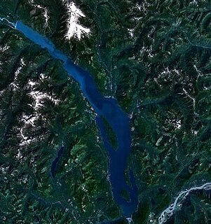
Harrison Lake is the largest lake in the southern Coast Mountains of Canada, being about 250 square kilometres (95 mi²) in area. It is about 60 km (37 mi) in length and at its widest almost 9 km (5.6 mi) across. Its southern end, at the resort community of Harrison Hot Springs, is c. 95 km east of downtown Vancouver. East of the lake are the Lillooet Ranges while to the west are the Douglas Ranges. The lake is the last of a series of large north-south glacial valleys tributary to the Fraser along its north bank east of Vancouver, British Columbia. The others to the west are the Chehalis, Stave, Alouette, Pitt, and Coquitlam Rivers.

The Klinaklini River is one of the major rivers of the Pacific Ranges section of the Coast Mountains in the Canadian province of British Columbia. It originates in the Pantheon Range and empties into the head of Knight Inlet.
The Stuart River or Nak'alkoh is one of the largest tributaries of the Nechako River in northeastern British Columbia, Canada. The Nechako is in turn one the more important tributaries of the Fraser River. The Stuart River flows 187 kilometres (116 mi) from Stuart Lake to its junction with the Nechako River. The river drains a portion of the Nechako Plateau—a gently-rolling region characterized by small lakes and tributaries. Low but impressive ridges interact with the river, creating high bluffs and hoodoos.

The West Road River or Blackwater River or Tiyakoh is an important tributary of the Fraser River, flowing generally north-eastward from the northern slopes of the Ilgachuz Range and across the Fraser Plateau in the Chilcotin region of central British Columbia, Canada. With only one major tributary, the Nazko River, its confluence with the Fraser is approximately 40 km northwest of Quesnel. It forms the division between the Chilcotin Plateau (S) and the Nechako Plateau (N), which are subdivisions of the Fraser Plateau.

The Kettle River is a 281-kilometre (175 mi) tributary of the Columbia River, encompassing a 10,877-square-kilometre (4,200 sq mi) drainage basin, of which 8,228 square kilometres (3,177 sq mi) are in southern British Columbia, Canada and 2,649 square kilometres (1,023 sq mi) in northeastern Washington, US.
The McGregor River is a tributary of the Fraser River in the Canadian province of British Columbia.

The Kitimat River is a river in the Canadian province of British Columbia. It originates in the Kitimat Ranges, near the sources of the Dala River, Kemano River, Atna River, and Clore River. It flows in a curve north, then west, then south, emptying into Kitimat Arm at the head of Douglas Channel, at the town of Kitimat.
The Tahltan River is a tributary of the Stikine River in northwest part of the province of British Columbia, Canada. It flows generally east and southeast about 95 km (59 mi) to join the Stikine River at Tahltan, British Columbia.
The Stawamus River is a small, creek-like river in British Columbia. It enters the Howe Sound east of the mouth of the Squamish River.

The Cheslatta Carrier Nation or Cheslatta T'En, of the Dakelh or Carrier people (Ta-cullies, meaning "people who go upon water", whose traditional lands where originally where the Kitimat Kemano Project I was built, form a large portion of the Central Interior of present-day British Columbia, Canada, is a First Nation of the Nechako River at the headwaters of the Fraser River.
The Stellako River is an 11.3-kilometre (7.0 mi) long river in the Nechako Plateau region of the Canadian province of British Columbia. It flows from François Lake to Fraser Lake, which joins the Nechako River via the short Nautley River. The Nechako is a tributary of the Fraser River.
The Cheslatta River is a tributary of the Nechako River, one of the main tributaries of the Fraser River, in the Canadian province of British Columbia. It flows through the Nechako Plateau. Before the construction of Kenney Dam in the early 1950s the Cheslatta was a minor tributary of the Nechako. Today the Nechako River is dry above the Cheslatta, which provides all its source water.
Cheslatta Lake is a large freshwater lake located between François Lake and the western end of the Nechako Reservoir, Range 4 Coast Land District. It is in the Regional District of Bulkley-Nechako, British Columbia.
Scotch Creek is a stream in the British Columbia Interior of Canada, located on the north side of Shuswap Lake. It is part of the Thompson River watershed, which is a tributary to the Fraser River. It flows from the Shuswap Highlands into Shuswap Lake just west of the community of Scotch Creek. It was named for Scottish gold prospectors who worked the creek with placer mining operations in the 1860s. The creek's headwaters are near Pukeshun Mountain, and flow southwest and south for 56.5 kilometres (35.1 mi). The creek supports sockeye salmon, which breed in the creek during a small salmon run in the autumn.
The Ecstall River is a tributary of the Skeena River in the province of British Columbia, Canada. It originates in the Kitimat Ranges, and flows about 110 km (68 mi) to the lower tidal reach of the Skeena River at Port Essington, about 30 km (19 mi) southeast of Prince Rupert, 95 km (59 mi) southwest of Terrace, and 85 km (53 mi) northwest of Kitimat. Its drainage basin covers about 1,485 km2 (573 sq mi) and contains the largest blocks of unlogged land on the north coast of British Columbia, although large-scale industrial logging operations, both active and proposed, have been occurring in the watershed since the 1980s.
The Gitnadoix River is a tributary of the Skeena River in the province of British Columbia, Canada. It originates in the Kitimat Ranges, and flows about 38 km (24 mi) north to the Skeena River, about 45 km (28 mi) west of Terrace.
References
- 1 2 "Chilako River". BC Geographical Names.
- ↑ Mouth elevation derived from ASTER Global Digital Elevation Model, using GeoLocator, and BCGNIS source coordinates.
- ↑ Akrigg, G. P. V.; Akrigg, Helen B. (1997). British Columbia Place Names . UBC Press. p. 45. ISBN 978-0-7748-0637-4 . Retrieved 4 August 2013.