
The Rose Fitzgerald Kennedy Greenway is a linear park located in several Downtown Boston neighborhoods. It consists of landscaped gardens, promenades, plazas, fountains, art, and specialty lighting systems that stretch over one mile through Chinatown, the Financial District, the Waterfront, and North End neighborhoods. Officially opened in October 2008, the 17-acre Greenway sits on land created from demolition of the John F. Fitzgerald Expressway as part of the Big Dig project.
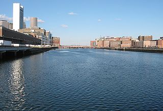
Fort Point Channel is a maritime channel separating South Boston from downtown Boston, Massachusetts, feeding into Boston Harbor. The south part of it has been gradually filled in for use by the South Bay rail yard and several highways. At its south end, the channel once widened into South Bay, from which the Roxbury Canal continued southwest where the Massachusetts Avenue Connector is now. The Boston Tea Party occurred at its northern end. The channel is surrounded by the Fort Point neighborhood, which is also named after the same colonial-era fort.

HP Hood LLC is an American dairy company based in Lynnfield, Massachusetts. Hood was founded in 1846 in Charlestown, Massachusetts, by Harvey Perley Hood. Recent company acquisitions by HP Hood have expanded its reach from predominantly New England to the broader United States. Today, the company has an annual sales revenue of about $2.7 billion.

Boston Children's Museum is a children's museum in Boston, Massachusetts, dedicated to the education of children. Located on Children's Wharf along the Fort Point Channel, Boston Children's Museum is the second oldest children's museum in the United States. It contains many activities meant to both amuse and educate young children.

Milk crates are square or rectangular interlocking boxes that are used to transport milk and other products from dairies to retail establishments.

The Boston Tea Party was an American political and mercantile protest by the Sons of Liberty in Boston, Massachusetts, on December 16, 1773. The target was the Tea Act of May 10, 1773, which allowed the British East India Company to sell tea from China in American colonies without paying taxes apart from those imposed by the Townshend Acts. The Sons of Liberty strongly opposed the taxes in the Townshend Act as a violation of their rights. Protesters, some disguised as American Indians, destroyed an entire shipment of tea sent by the East India Company.

The Harbor Towers are two 40-story residential towers located on the waterfront of Boston, Massachusetts, located between the New England Aquarium and the Rowes Wharf mixed-use development. Harbor Towers I, the taller of the two towers, stands at 400.0 feet (121.9 m), while Harbor Towers II rises 396 feet (121 m). Harbor Towers I is in a tie as 29th-tallest building in Boston. They were designed by Henry N. Cobb of I. M. Pei & Partners.

Long Wharf is a historic American pier in Boston, Massachusetts, built between 1710 and 1721. It once extended from State Street nearly a half-mile into Boston Harbor; today, the much-shortened wharf functions as a dock for passenger ferries and sightseeing boats.

The current incarnation of Rowes Wharf is a modern development in downtown Boston, Massachusetts. It is best known for the Boston Harbor Hotel's multi-story arch over the wide public plaza between Atlantic Avenue and the Boston Harbor waterfront. Along the waterfront can be found a marina, restaurants, a water transportation terminal, and a floating stage offering free concerts and movies during the summer.
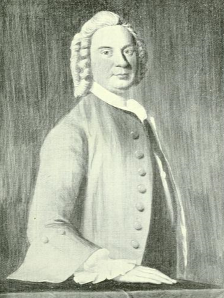
John Rowe (1715–1787) was a property developer and merchant in 18th century Boston, Massachusetts. As a merchant, John Rowe's most famous cargo was the tea that played a starring role in the Boston Tea Party. As a developer, his name is remembered to this day in the name of Rowes Wharf, a modern development in downtown Boston on the site of his original wharf.

Port Plaza Mall was an urban area shopping mall/multi-use facility located in downtown Green Bay, Wisconsin. The mall opened on August 10, 1977, and featured 3 anchor stores over the years, with JCPenney and H.C. Prange open at its launch and Boston Store added by 1982. The mall would go into a state of decline in the late 1990s and 2000s, leading up to its closure on February 27, 2006. The mall property was razed during the 1st half of 2012 as part of a redevelopment project; the headquarters of Schreiber Foods now stands on the main mall footprint.

Fort Point is a neighborhood or district of Boston, Massachusetts, and where a fort stood which guarded the city in colonial times.

Downtown Boston is the central business district of Boston, Massachusetts, United States. The city of Boston was founded in 1630. The largest of the city's commercial districts, Downtown is the location of many corporate or regional headquarters; city, county, state and federal government facilities; and many of Boston's tourist attractions. Similar to other central business districts in the U.S., Downtown has recently undergone a transformation that included the construction of new condos and lofts, renovation of historic buildings, and arrival of new residents and businesses. It is represented in the Boston City Council by District 2's Bill Linehan.

The Fort Point Channel Historic District is an historic district located along Congress, Summer and A streets in South Boston on the south side of Fort Point Channel.

Boston Harborwalk is a public walkway that follows the edge of piers, wharves, beaches, and shoreline around Boston Harbor. When fully completed it will extend a distance of 47 miles (76 km) from East Boston to the Neponset River.
Milk Street is a street in the financial district of Boston, Massachusetts, which was one of Boston's earliest highways. The name "Milk Street" was most likely given to the street in 1708 due to a milk market at the location, although Grace Croft's 1952 work "History and Genealogy of Milk Family" instead proposes that Milk Street may have been named for John Milk, an early shipwright in Boston. The land was originally conveyed to his father, also John Milk, in October 1666.

India Wharf in Boston, Massachusetts, flourished in the 19th century, when it was one of the largest commercial wharves in the port. The structure began in 1804 to accommodate international trade at a time when several other improvements to the Boston waterfront occurred, such as the creation of Broad Street and India Street.

Congress Street in Boston, Massachusetts, is located in the Financial District and South Boston. It was first named in 1800. It was extended in 1854 as far as Atlantic Avenue, and in 1874 across Fort Point Channel into South Boston. Today's Congress Street consists of several segments of streets, previously named Atkinson's Street, Dalton Street, Gray's Alley, Leverett's Lane, Quaker Lane, and Shrimpton's Lane.

The Custom House in Boston, Massachusetts, was established in the 17th century and stood near the waterfront in several successive locations through the years. In 1849 the U.S. federal government constructed a neoclassical building on State Street; it remains the "Custom House" known to Bostonians today. A tower was added in 1915; the building joined the National Register of Historic Places in 1973 and was designated a Boston Landmark by the Boston Landmarks Commission in 1986.

The Custom House Block, built in 1845-87 in Boston, Massachusetts, is a former warehouse located on Long Wharf, at the end of State Street. Architect Isaiah Rogers designed the four-storey building, constructed of granite and brick. In its 19th-century heyday, it contributed to the life of "Boston's busiest pier, commercial port, and embarkation point for travelers." Today private owners maintain the site.


