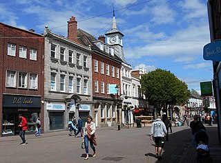
Nuneaton is a market town in Warwickshire, England, close to the county border with Leicestershire to the north-east. Nuneaton's population at the 2021 census was 88,813, making it the largest town in Warwickshire. Nuneaton's urban area, which also includes the large villages of Bulkington and Hartshill, had a population of 99,372 at the 2021 census.

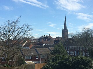
Bedworth is a market town in the borough of Nuneaton and Bedworth, Warwickshire, England. It is situated between Coventry, 6 miles to the south, and Nuneaton, 3 miles (5 km) to the north.
Nuneaton and Bedworth is a local government district with borough status in Warwickshire, England. It includes the towns of Nuneaton and Bedworth, as well as a modest rural hinterland including the village of Bulkington.

Warwickshire is a ceremonial county in the West Midlands of England. It is bordered by Staffordshire and Leicestershire to the north, Northamptonshire to the east, Oxfordshire and Gloucestershire to the south, and Worcestershire and the West Midlands county to the west. The largest settlement is Nuneaton and the county town is Warwick.

Bulkington is a large village and former civil parish near Bedworth, in the Nuneaton and Bedworth district of Warwickshire, England. In the 2011 census the ward had a population of 6,146 decreasing slightly to 6,080 at the 2021 census. It is located around 6 miles (10 km) northeast of Coventry, just south of the town of Nuneaton, east of Bedworth and 5 miles (8 km) southwest of Hinckley. Despite historically having stronger links with Bedworth, Bulkington forms part of the Nuneaton Urban Area. Bulkington was mentioned in the Domesday Book as Bochintone, meaning "estate associated with a man called Bulca".
Coleshill is a market town and civil parish in the North Warwickshire district of Warwickshire, England, taking its name from the River Cole, on which it stands. It had a population of 6,900 in the 2021 Census, and is situated 11 miles (18 km)east of Birmingham, 9 miles (14 km) southeast of Sutton Coldfield, 11 miles (18 km) south of Tamworth, 13 miles (21 km) northwest of Coventry by road and 13 miles (21km) west of Nuneaton. It borders the parish village of Kingshurst in the Metropolitan Borough of Solihull to the west. It is also home to the 502 year The Coleshill School seated next to the dual carriageway.

Nuneaton is a constituency in Warwickshire represented in the House of Commons of the UK Parliament since 2024 by Jodie Gosling of the Labour Party.

Bilton is a suburb of Rugby in Warwickshire, England, located about 1.5 miles (2.4 km) south-west of Rugby town centre. It is also a ward of the Borough of Rugby, which at the 2021 Census had a population of 6,544. It comprises much of the western half of the town. Historically a village in its own right, Bilton was incorporated into Rugby in 1932.

Hemlingford Hundred was one of the four hundreds that the English county of Warwickshire was divided into, along with Kington, Knightlow and Barlichway. It was recorded in the Domesday Book under the name of Coleshill.

Baxterley is a small village and civil parish in the North Warwickshire district of Warwickshire in England. According to the 2001 Census, it had a population of 335, reducing to 328 at the 2011 Census. The village is about two miles west of Atherstone and is home to Jaguar Land Rover's national distribution centre.

Hartshill is a large village and civil parish in North Warwickshire, England, adjoined with the much larger town of Nuneaton, the town centre of which is 2.5 miles (4 km) to the south-east. The parish borders the district of Nuneaton and Bedworth at the south, the North Warwickshire district parishes of Ansley at the south-west, Mancetter at the north-west, and Caldecote at the east, and the parish of Witherley in Leicestershire to the north-east from which it is separated by the A5 road. The market town of Atherstone is 3.5 miles (6 km) to the north-west.
Ash Green is a village in the Nuneaton and Bedworth borough of Warwickshire, England. It forms part of the Coventry and Bedworth urban area.

Exhall is a suburban village in the Nuneaton and Bedworth borough in Warwickshire, England. It forms part of the Coventry and Bedworth urban area and is contiguous with the Coventry suburb of Longford and the village of Hawkesbury Village.
Attleborough is an area of Nuneaton, Warwickshire. It is about a mile south-east of the town centre.
Dordon is a village and civil parish in the North Warwickshire district of the county of Warwickshire in England and close to the border with Staffordshire. The village is located on the A5 national route and is contiguous with the larger village of Polesworth. Other nearby places include Tamworth, Atherstone, Grendon, Wood End Village, Baddesley Ensor and Nuneaton. In 2001 the population for the parish of Dordon was 3,225, reducing slightly to 3,215 at the 2011 census.

Merevale is a small village and civil parish in the North Warwickshire district of the county of Warwickshire in England. Located about one and a half miles west of Atherstone, it is the site of a medieval Cistercian Abbey and Merevale Hall.

Bermuda Park railway station is a railway station in the Bermuda area of Nuneaton, Warwickshire, England. It serves the Bermuda Park Industrial Estate, on the Coventry to Nuneaton Line between the existing stations at Nuneaton and Bedworth. Funding for the new station was approved in December 2011, along with that for the new Coventry Arena railway station. Both stations opened on 18 January 2016.

Chilvers Coton was a railway station on the Coventry to Nuneaton Line, which served the Chilvers Coton area of Nuneaton, south of the town centre. It opened in 1850, along with the line, and was closed in 1965 when passenger services on the route were withdrawn.

The Roman Catholic Parish of Our Lady of the Angels is located in Nuneaton, Warwickshire, England. The parish is part of the Roman Catholic Archdiocese of Birmingham and a part of the Rugby Deanery. The current Parish Priest is Fr. Jimmy Lutwama. Working alongside the diocesan clergy are a group of Presentation Sisters.

Nuneaton Town Hall is a municipal building on Coton Road in the town of Nuneaton, Warwickshire, England. The building is the headquarters of Nuneaton and Bedworth Borough Council.

