Environment
The upper reaches of the Chinko river define the border between the Haute-Kotto and Haut-Mbomou prefectures. For most of its length it flows in a SSW direction through Mbomou prefecture to its convergence with the Mbomou River. The Mbomou plateau has an elevation of 500–700 metres (1,600–2,300 ft), slightly inclined to the south, on the Asande rise between the Lake Chad depression to the north and the Congo Basin to the south.
The Chinko Nature Reserve is a protected area in the Chinko River basin. It covers 17,600 square kilometres (6,800 sq mi). It is managed by the nonprofit conservation organization African Parks as part of a fifty-year public–private partnership with the Ministry of Water, Forest, Hunting and Fishing. African wild dogs have been documented in the south of the CAR in the Chinko/Mbari drainage basin in 2013.

The Mbomou River or Bomu forms part of the boundary between the Central African Republic (CAR) and the Democratic Republic of the Congo (DRC).
Obo is the capital of Haut-Mbomou, one of the 14 prefectures of the Central African Republic. It is close to the African Pole of Inaccessibility.

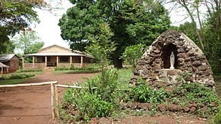
Bangassou is a city in the south eastern Central African Republic, lying on the north bank of the Mbomou River. It has a population of 24,447 and is the capital of the Mbomou prefecture. It is known for its wildlife, market, and nearby Bangassou Airport and is linked by ferry to the Democratic Republic of Congo on the south bank. The city is also home to the Roman Catholic Diocese of Bangassou.

Rafaï is a town and sub-prefecture on the Chinko River, in the Central African Republic prefecture of Mbomou. Its estimated population is about 14,000 people.
Mongoumba is a town located in the Lobaye Prefecture, Central African Republic. From 1905–1933, Mongoumba was part of Moyen-Congo.

Pousargues's mongoose, also known as the African tropical savannah mongoose, is a mongoose native to Central Africa. It is listed as data deficient on the IUCN Red List as little is known about its distribution and ecology. It is the only species in the genus Dologale.
Bangassou Airport is an airport serving Bangassou, a city on the Mbomou River in the Mbomou prefecture of the Central African Republic. The Mbomou River forms the local border with the Democratic Republic of the Congo.

Djemah is a town and sub-prefecture in the Haut-Mbomou Prefecture of the south-eastern Central African Republic. It is the least-populous sub-prefecture in the country. The town is largely neglected by the central government since the country gained independence from France in 1960.

Jean Jacques Marie Ferdinand de Béhagle was a French explorer of Africa. He served with the colonial service in Algeria and travelled in the Congo and Ubangi region. While attempting to find a viable land route from the Congo to the Mediterranean via Chad he was taken prisoner by Rabih az-Zubayr and hanged.

Alphonse van Gèle, also written van Gele or Vangele, was a Belgian soldier who served as the Vice-Governor General of the Congo Free State from December 1897 until January 1899. He established the Equator Station, or Station de l’Équateur, today Mbandaka, and concluded a treaty with the powerful Zanzibar trader Tippu Tip at the Stanley Falls station, today Kisangani. He is known for having confirmed that the Uele River was the upper part of the Ubangi River.
Uele District was a district of the Congo Free State and the Belgian Congo. It roughly corresponded to the current provinces of Bas-Uélé and Haut-Uélé.
The Itimbiri River is a right tributary of the Congo River, which it joins above Bumba. At one time it was important as a navigable waterway for transporting good from the northeast of the country down to the Congo.
The Mbari River is a river of the Central African Republic. It is a right tributary of the Mbomou River not far to the north of where the Mbomou joins the Uele River to form the Ubangi River.
Jules Alexandre Milz was a Belgian soldier who was active in exploring the northeast of the Congo Free State. He traveled extensively in Uele District, where he resolved the question of whether the Uele River was the upper portion of the Ubangi River. He was second in command of an expedition to the Nile in 1891–1892, and took over command after the leader died.

Willem Frans Van Kerckhoven, or Guillaume François van Kerckhoven was a Belgian soldier, explorer, colonial administrator who was active in the service of the International Association of the Congo and the subsequent Congo Free State. He is known for his extended expedition through the Uele River basin and onward towards the Nile, which was responsible for the deaths of over 1,800 people and established a Belgian presence in the region. Van Kerckhoven died in an accident before reaching the Nile.

Léon-Charles-Édouard Hanolet was a Belgian soldier, explorer and colonial administrator. He is known for his explorations in 1894–1895 in what is now the Central African Republic, which led to an agreement between France and Belgium that the Ubangi-Mbomou rivers would form the boundary between their territories. He defended the Lado Enclave against the retreating Mahdist forces in 1898.
Georges-Edouard le Marinel was a Belgian soldier, engineer, explorer and colonial administrator. He is known for leading explorations of the country around the Ubangi River and Mbomou River, which later became the boundaries between French and Belgian territory.

Central African nationality law is regulated by the Constitution of the Central African Republic, as amended; the Central African Republic's Nationality Code, and its revisions; and various international agreements to which the country is a signatory. These laws determine who is, or is eligible to be, a national of the Central African Republic. The legal means to acquire nationality, formal legal membership in a nation, differ from the domestic relationship of rights and obligations between a national and the nation, known as citizenship. Central African nationality is typically obtained under the principle of jus sanguinis, i.e. by birth in the Central African Republic or abroad to parents with Central African nationality. It can be granted to persons with an affiliation to the country, or to a permanent resident who has lived in the country for a given period of time through naturalization.

Sultan Djabir was ruler of a region on the Uele River in what is now the Democratic Republic of the Congo. He engaged in the ivory and slave trade with Muslims from the north and with Belgians from the south. Eventually he was forced to flee to the Sudan when he refused to pay tribute to the Congo Free State.
