Zambia, officially the Republic of Zambia, is a landlocked country at the crossroads of Central, Southern and East Africa. It is typically referred to being in South-Central Africa or Southern Africa. It is bordered to the north by Democratic Republic of the Congo, Tanzania to the north-east, Malawi to the east, Mozambique to the southeast, Zimbabwe and Botswana to the south, Namibia to the southwest, and Angola to the west. The capital city of Zambia is Lusaka, located in the south-central part of Zambia. The population is concentrated mainly around Lusaka in the south and the Copperbelt Province to the north, the core economic hubs of the country.

The Zambezi is the fourth-longest river in Africa, the longest east-flowing river in Africa and the largest flowing into the Indian Ocean from Africa. Its drainage basin covers 1,390,000 km2 (540,000 sq mi), slightly less than half of the Nile's. The 2,574 km (1,599 mi) river rises in Zambia and flows through eastern Angola, along the north-eastern border of Namibia and the northern border of Botswana, then along the border between Zambia and Zimbabwe to Mozambique, where it crosses the country to empty into the Indian Ocean.

Western Province is one of the 10 provinces in Zambia and encompasses most of the area formerly known as Barotseland. The capital is Mongu, and together with the neighbouring town of Limulunga, Mongu is treated as the capital of Barotseland.

Victoria Falls, popularly known as Vic Falls, is a resort town and city in the province of Matabeleland North, Zimbabwe. It lies on the southern bank of the Zambezi River at the western end of Victoria Falls themselves. According to the 2022 Population Census, the town had a population of 35,199.
Kalabo is an urban centre and the seat of Kalabo District, in the Western Province of Zambia.

Chavuma is a town in the North-Western Province of Zambia, lying immediately south of the border with Angola. The town is approximately 1,100 kilometers from Lusaka and 11 kilometers from the Angolan border town of Kalipande. It lies on the Zambezi River. Local attractions include the Chavuma Falls, while a market takes place on the border, permitting people from both nations to trade.

Kasane is a town in Botswana, close to Africa's 'Four Corners', where the borders of Botswana, Namibia, Zambia and Zimbabwe almost meet. The town is at the far northeastern corner of Botswana where it serves as the administrative center of the Chobe District. The population of Kasane was 9,244 at the 2011 census.

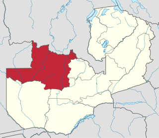
North-Western Province is one of ten Provinces of Zambia. It covers an area of 125,826 km2 (48,582 sq mi), has a population of 1,278,357 and a population density of 20 per square kilometre as of 2021. It is the most sparsely populated province in the country. The provincial capital is Solwezi. The literacy rate stood at 63 per cent in 2010 against a national average of 70.2 per cent. The rural population constituted 77.45%, while the urban population was 22.55%. North-Western Province is bordered along Angola in the west, the Democratic Republic of Congo in the north, Copperbelt Province in the east, Central in the south-east, and Western Province in the south-west.

The Katima Mulilo Bridge carries the TransCaprivi Highway over the Zambezi River between Katima Mulilo, Namibia and Sesheke, Zambia. It is a road bridge, completed in 2004, 900 metres long and with 19 spans. It links Namibia's Trans–Caprivi Highway to the Zambian road network, forming a section of the trade route from south-central Africa to the Atlantic known as the Walvis Bay Corridor. It also carries tourist traffic.

Stephenville Crossing is a town in the Canadian province of Newfoundland and Labrador. It is on the island of Newfoundland at the easternmost limit of Bay St. George.

The Barotse Floodplain, also known as the Bulozi Plain, Lyondo or the Zambezi Floodplain, is one of Africa's great wetlands, on the Zambezi River in the Western Province of Zambia. It is a designated Ramsar site, regarded as being of high conservation value.

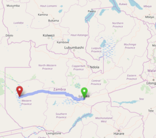
The Lusaka–Mongu Road of Zambia runs 580 km from the capital, Lusaka, to Mongu, capital of the Western Province. It connects that province to the rest of the country, as well as being one of two routes to the south-west extremity of North-Western Province. It also serves as the main highway of the western half of Central Province. The entire route from Lusaka to Mongu is designated as the M9 road.

The following outline is provided as an overview of and topical guide to Zambia:
Zambia, officially known as the Republic of Zambia, is a landlocked country in Southern Africa. The neighbouring countries are the Democratic Republic of the Congo to the north, Tanzania to the north-east, Malawi to the east, Mozambique, Zimbabwe, Botswana, and Namibia to the south, and Angola to the west. The capital city is Lusaka, located in the southeast of the country. The population is concentrated mainly around the capital and the Copperbelt to the northwest.

Nchelenge District is a district of Zambia, located in the Luapula Province. The capital lies at Nchelenge. As of the 2000 Zambian Census, the district had a population of 111,119 people.
Kalene Hill is a community in the northwest of Zambia near a hill by the same name about 3 kilometres (2 mi) to the southeast. It is part of the Ikelenge District. Kalene Hill was the site of an early medical mission. The hospital is still important to the region.

Karanda Mission Hospital was established in 1961 to meet the needs of mission stations in the Zambezi River valley which were established as churches and then, as the abundant health care challenges were seen, small dispensaries/clinics were developed along with the churches. To help the clinics, the hospital was built. Karanda is in a remote area of northern Zimbabwe nearest to Mount Darwin. Its location is approximately 200 kilometres (120 mi) from the capital, Harare.
Sioma is a town on the west bank of the Zambezi River in the Western Province of Zambia. Since 2012 it has been the capital of the Sioma District.
Mwandi is a small town on the Zambezi in the district of the same name of the Western Province in Zambia. The town is 120 km west of Livingstone, on the M10 Road to Sesheke. The village is part of the region known as Barotseland. The town is the seat of a parliamentary constituency of the same name.
The M10 road is a road in Zambia. It goes from Livingstone, through Sesheke and Senanga, to Mongu. The road is approximately 508 kilometres and follows the Zambezi River for its entire length.


