Chiribaya culture

Last updated
Chiribaya
c. 900–c. 1450
Tupac-inca-conquest.png
Extent of the Chiribaya culture in the middle of the 15th century.
Location Atacama Desert
Official languages Puquina
Historical era Late Intermediate
 Established
c. 900
 Disestablished
c. 1450
Preceded by
Succeeded by
Blank.png Wari Empire
Inca Empire Banner of the Inca Empire.svg

The Chiribaya culture flourished near the coast of southern Peru and adjacent Chile from 700 CE until Spanish settlement in the late 16th century. The classic phase of the Chiribaya culture was from 1000 CE until 1360 CE. The Chiribaya culture consisted of both maritime settlements along 220 kilometres (140 mi) of the Pacific Ocean coast and agricultural settlements inland in valleys of the Osmore and Tambo rivers in Peru and the Lluta river and Azapa Valley in Chile.

Contents

The lower Osmore valley, one of the centers of the Chiribaya culture, has been extensively studied by archaeologists because it appears to have been colonized by both the Wari and Tihuanco empires and the later Lupaca people and the Inca Empire. These highland empires relied on the lower-altitude valleys to supply them with agricultural products such as maize and chile peppers.

Environment

Chiribaya pottery in the Arica (Chile) museum. Arica057.jpg
Chiribaya pottery in the Arica (Chile) museum.

The people of the Chiribaya culture lived near the Pacific Ocean in the Atacama Desert which is commonly known as the driest non-polar place in the world., [1] [2] The total annual precipitation at Ilo, Peru, at the mouth of the Osmore River is .1 inches (2.5 mm). [3] Agriculture is only possible where water from the rivers and a few springs is available for irrigation. The four rivers in the territory of the Chiribaya culture and their tributaries rise about 130 kilometres (81 mi) inland in the wetter Andes at elevations of up to 5,000 metres (16,000 ft). [4] The cold Humboldt Current offshore creates one of the world's richest marine ecosystems and supports large numbers of fish, marine mammals, and birds. [5]

Cerro Baul, the archaeological site is located on the flat top of a mountain in the Osmore River valley. Cerro Baul.jpg
Cerro Baúl, the archaeological site is located on the flat top of a mountain in the Osmore River valley.

Chiribaya inland sites are usually located along rivers, which provide water for agricultural production, although the amount of suitable land was limited both by the steepness of the terrain and, near the ocean, by limited quantities of water for irrigation. [6] Camelid pastoralism was also an important means of subsistence and for production of textiles. [7]

Antecedents

Evidence of man's presence in what would become the Chiribaya cultural area dates back to before 7,000 BCE with the Chinchorro culture, the people of which practiced mummification thousands of years before Egypt did. These early inhabitants lived on the coast and 89 percent of their subsistence came from the sea, only 6 percent came from terrestrial vegetation and 5 percent from terrestrial meat. The Chinchorro culture ended about 1100 BCE. [8] From about 400 BCE to 300 CE, the Huaracane culture introduced agriculture to inland areas of the Osmore River region. In the centuries which followed, the area was influenced by the Wari and Tihuanacan empires who founded colonies in the Osmore valley. [9]

Description

Rather than being a unified state under a single government, the Chiribaya area is often described as a señorío, a collection of loosely affiliated communities each headed by a local leader and resembling the manors of medieval Europe. [10]

Cerro Sagrado (Sacred Mountain) in the Azapa valley of Chile features a large number of geoglyphs. Arica011.jpg
Cerro Sagrado (Sacred Mountain) in the Azapa valley of Chile features a large number of geoglyphs.

The Chiribaya culture is most often discussed for its relationship with "verticality"' -- the practice by pre-historic cultures of establishing zones of economic specialization at different altitudes to produce a wide variety of food and industrial crops. High altitude Andean cultures and civilizations established colonies at lower elevations near the Pacific Coast or in the Amazon River basin. The colonies were often not contiguous with the highland homes of the cultures, but sovereignty of the homeland over the distant colonies was retained. In the Osmore river valley, and probably in the other river valleys, there were two principal zones. The coast was inhabited by "pescadores" (fisherman); and the upland area a few miles inland mostly at elevations of 1,000 metres (3,300 ft) to 2,000 metres (6,600 ft) was inhabited by "labradores" (farmers) who primarily grew maize and chili peppers. The two zones traded products with each other and supplied the high altitude cultures. Llamas and alpacas were raised in both zones, probably being more important in the inland areas as the property of the cultural elites. [11]

The fishermen living near the coast also practiced limited agriculture and pastoralism at the mouth of rivers and in the lomas (fog-oases) known to have existed near the coast both north and south of the city of Ilo. [12]

However, verticality and the establishment of colonies by highland peoples may vary on a case to case basis. Genetic studies indicates that the Chiribaya people of the lower Osmore River Valley and nearby coast were likely intrusive— descendants in part of Wari and Tiwanaku colonists—while the Chiribaya of the Azapa Valley of Chile were more likely to be the descendants of the ancient Chinchorro culture that flourished in the same area. This suggests that the highland cultures had little direct contact with the inhabitants of the Azapa valley. [13]

Demise

About 1360 CE, an uncharacteristic flood, probably caused by the El Niño Southern Oscillation, destroyed the irrigation systems and many settlements in the Osmore valley. The area was depopulated and many of the extensive irrigation works were not repaired until the arrival of Spanish colonists in the late 16th century. The Chiribaya people were probably absorbed by the Estuquiña people who lived in the upper Osmore valley. The area was also probably colonized—or came under the political control—of the Lupaca from the Lake Titicaca area and by the Incas in the 15th and early 16th century. [14]

Chiribaya dogs

In 2006, archaeologists found the mummified remains of 43 dogs in a Chiribaya cemetery near Ilo. Some were buried with blankets and food. The dogs were used to herd llamas. Peruvian authorities are attempting to get international recognition of present-day Chiribaya shepherd dogs, which resemble a small Golden Retriever, as a unique breed. [15]

Related Research Articles

<span class="mw-page-title-main">Wari culture</span> Pre-Inca Culture, c. 500 BCE–1000 CE

The Wari were a Middle Horizon civilization that flourished in the south-central Andes and coastal area of modern-day Peru, from about 500 to 1000 AD.

<span class="mw-page-title-main">Moquegua</span> City in Peru

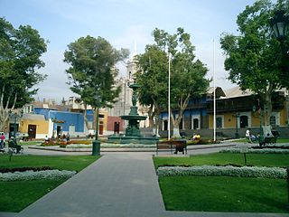
Moquegua is a city in southern Peru, located in the Department of Moquegua, of which it is the capital. It is also capital of Mariscal Nieto Province and Moquegua District. It is located 1144 kilometers south of the capital city of Lima.

<span class="mw-page-title-main">Ilo, Peru</span> City in Moquegua, Peru

Ilo is a port city in southern Peru, with 66,118 inhabitants. It is the second largest city in the Moquegua Region and capital of the Ilo Province.

Azapa Valley is a fertile and narrow oasis in Arica y Parinacota Region, Chile. It is framed between two sere hills and divided by the San Jose River that runs during the summer season. It is located three kilometres (1.9 mi) from the city of Arica. This jewel of the north has a unique climate that permits the farming of a great variety of fruits and vegetables throughout the year. This is in addition to the unique Azapa olives, renowned for their violet color and bitter flavor that also gives birth to a hearty oil.

<span class="mw-page-title-main">Paracas culture</span> Archaeological culture

The Paracas culture was an Andean society existing between approximately 800 BCE and 100 BCE, with an extensive knowledge of irrigation and water management and that made significant contributions in the textile arts. It was located in what today is the Ica Region of Peru. Most information about the lives of the Paracas people comes from excavations at the large seaside Paracas site on the Paracas Peninsula, first formally investigated in the 1920s by Peruvian archaeologist Julio Tello.

<span class="mw-page-title-main">Chincha culture</span> Native American culture

The Chincha culture was the culture of a Native Peruvian people living near the Pacific Ocean in south west Peru. The Chincha Kingdom and their culture flourished in the Late Intermediate Period, also known as the regional states period of pre-Columbian Peru. They became part of the Inca Empire around 1480. They were prominent as sea-going traders and lived in a large and fertile oasis valley. La Centinela is an archaeological ruin associated with the Chincha. It is located near the present-day city of Chincha Alta.

<span class="mw-page-title-main">Chinchorro mummies</span> Mummified remains of individuals from the South American Chinchorro culture

The Chinchorro mummies are mummified remains of individuals from the South American Chinchorro culture, found in what is now northern Chile. They are the oldest examples of artificially mummified human remains, having been buried up to two thousand years before the Egyptian mummies. The earliest mummy that has been found in Egypt dated around 3000 BCE, the oldest anthropogenically modified Chinchorro mummy dates from around 5050 BCE.

<span class="mw-page-title-main">Puquios</span> Underground aqueducts in Peru and Chile

Puquios are ancient systems of subterranean aqueducts which allow water to be transported over long distances in hot dry climates without loss of much of the water to evaporation. Puquios are found in the coastal deserts of southern Peru, especially in the Nazca region, and northern Chile. Forty-three puquios in the Nazca region were still in use in the early 21st century and relied upon to bring fresh water for irrigation and domestic use into desert settlements. The origin and dating of the Nazca puquios is disputed, although some archaeologists have estimated that their construction began about 500 CE by indigenous people of the Nazca culture.

<span class="mw-page-title-main">Lupaca</span>

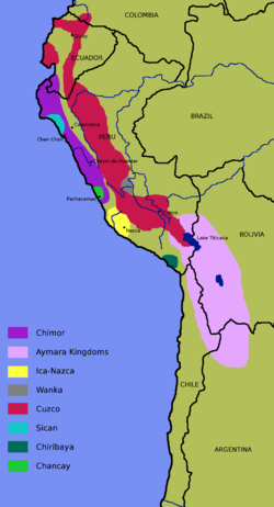
The Lupaca, Lupaka, or Lupaqa people were one of the divisions of the ancestral Aymaras. The Lupaca lived for many centuries near Lake Titicaca in Peru and their lands possibly extended into Bolivia. The Lupacas and other Aymara peoples formed powerful kingdoms after the collapse of the Tiwanaku Empire in the 11th century. In the mid 15th century they were conquered by the Inca Empire and in the 1530s came under the control of the Spanish Empire.

The Chiribaya Dog or Peruvian Shepherd Dog is an extinct pre-Columbian breed of dog from the southwest of Peru. It has been established that it was a llama herding dog. The dogs were not only an important part of the social structure of the ancient Peruvians, but they received special treatment after death as well. The remains were 1,000 years old.

<span class="mw-page-title-main">Andean civilizations</span> Civilizations of South Americas Andes Mountains

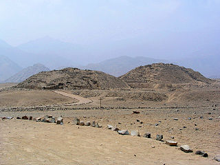
The Andean civilizations were complex societies of many cultures and peoples mainly developed in the river valleys of the coastal deserts of Peru. They stretched from the Andes of southern Colombia southward down the Andes to Chile and northwest Argentina. Archaeologists believe that Andean civilizations first developed on the narrow coastal plain of the Pacific Ocean. The Caral or Norte Chico civilization of Peru is the oldest known civilization in the Americas, dating back to 3200 BCE.

The prehispanic history of Chile refers to the period from the first human populations in the territory of Chile until the first European exploration of the region, by Spaniard Diego de Almagro in 1535-36.

<span class="mw-page-title-main">Osmore River</span> River in Moquegua Region, Peru

Osmore River system flows northeast to southwest in the Moquegua Region of southern coastal Peru. The river has its origin in the snow peaks of the Chuqi Ananta and Arundane mountains, at an elevation of 5,100 metres (16,700 ft) above sea level. It changes names as it descends from the Andes: From its origin it is called the Moquegua, then Osmore in the middle valley as Rio Coscori and Rio Tumilaca including where the river disappears into subterranean channels, and further down in the lower reaches as Rio Ilo.

<span class="mw-page-title-main">Andean preceramic</span>

The Andean preceramic refers to the early period of human occupation in the Andean area of South America that preceded the introduction of ceramics. This period is also called pre-ceramic or aceramic.

<span class="mw-page-title-main">Tiwanaku Empire</span> Pre-Columbian polity in Western Bolivia

The Tiwanaku Polity was a Pre-Columbian polity in western Bolivia based in the southern Lake Titicaca Basin. Tiwanaku was one of the most significant Andean civilizations. Its influence extended into present-day Peru and Chile and lasted from around 600 to 1000 AD. Its capital was the monumental city of Tiwanaku, located at the center of the polity's core area in the southern Lake Titicaca Basin. This area has clear evidence for large-scale agricultural production on raised fields that probably supported the urban population of the capital. Researchers debate whether these fields were administered by a bureaucratic state (top-down) or through a federation of communities with local autonomy. Tiwanaku was once thought to be an expansive military empire, based mostly on comparisons to the later Inca Empire. However, recent research suggests that labelling Tiwanaku as an empire or even different varieties of a state may even be misleading. Tiwanaku is missing a number of features used to define these types of polities: there is no defensive architecture at any Tiwanaku site or changes in weapon technology, there are no princely burials or other evidence of a ruling dynasty or a formal social hierarchy, no evidence of state-maintained roads or outposts, and no markets.

<span class="mw-page-title-main">Casma–Sechin culture</span>

The Casma–Sechin culture of Peru refers to the large concentration of pre-historic ruins in the valleys of the Casma River and its tributary the Sechin River and along the nearby coast of the Pacific Ocean. The ruins include major archaeological sites such as Sechin Bajo, Sechin Alto, Cerro Sechin, Mojeque, Chankillo, and Taukachi-Konkan, as well as other smaller sites. Most of these inland sites are found in the river valleys about 20 kilometres (12 mi) distant from the ocean. The seaside sites of Huaynuná and Las Haldas are found about 20 kilometres (12 mi) north and south of the mouth of the Casma River on the coast.

<span class="mw-page-title-main">Lomas</span> Areas of fog-watered vegetation in the coastal desert of Peru and northern Chile

Lomas, also called fog oases and mist oases, are areas of fog-watered vegetation in the coastal desert of Peru and northern Chile. About 100 lomas near the Pacific Ocean are identified between 5°S and 30°S latitude, a north–south distance of about 2,800 kilometres (1,700 mi). Lomas range in size from a small vegetated area to more than 40,000 hectares and their flora includes many endemic species. Apart from river valleys and the lomas the coastal desert is almost without vegetation. Scholars have described individual lomas as "an island of vegetation in a virtual ocean of desert."

<span class="mw-page-title-main">Pre-Columbian Bolivia</span>

Pre-Columbian Bolivia covers the historical period between 10,000 BCE, when the Upper Andes region was first populated and 1532, when Spanish conquistadors invaded Inca empire. The Andes region of Pre-Columbian South America was dominated by the Tiwanaku civilization until about 1200, when the regional kingdoms of the Aymara emerged as the most powerful of the ethnic groups living in the densely populated region surrounding Lake Titicaca. Power struggles continued until 1450, when the Incas incorporated upper Bolivia into their growing empire. Based in present-day Peru, the Incas instituted agricultural and mining practices that rivaled those put in place many years later by European conquerors. They also established a strong military force, and centralized political power. Despite their best efforts however, the Incas never completely controlled the nomadic tribes of the Bolivian lowlands, nor did they fully assimilate the Aymara kingdoms into their society. These internal divisions doomed the Inca Empire when European conquerors arrived.

<span class="mw-page-title-main">Chinchorro culture</span>

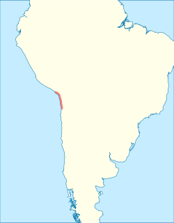
The Chinchorro culture of South America was a preceramic culture that lasted from 9,100 to 3,500 years BP. The people forming the Chinchorro culture were sedentary fishermen inhabiting the Pacific coastal region of current northern Chile and southern Peru. Presence of fresh water in the arid region on the coast facilitated human settlement in this area. The Chinchorro were famous for their detailed mummification and funerary practices. The area of the Chinchorro culture started to receive influences from the Andean Plateau around 4,000 BP, which led to the adoption of agriculture. Much later, it came under the influence of the Tiwanaku Empire.

<span class="mw-page-title-main">Aymara kingdoms</span>

The Aymara kingdoms, Aymara lordships or lake kingdoms were a group of native polities that flourished towards the Late Intermediate Period, after the fall of the Tiwanaku Empire, whose societies were geographically located in the Qullaw. They were developed between 1150 and 1477, before the kingdoms disappeared due to the military conquest of the Inca Empire. But the current Aymara population is estimated at two million located in the countries of Bolivia, Peru, Chile and Argentina. They used the Aymara and Puquina languages.

References

  1. "Yungay – the driest place in the world". Wondermondo. 3 November 2010. Retrieved 3 April 2013.
  2. Boehm, Richard G.; Armstrong, David G.; Hunkins, Francis P.; Reinhartz, Dennis; Lobrecht, Merry (2005). The World and its People (Teacher's wraparound ed.). New York: Glencoe/McGraw-Hill. p. 276. ISBN   978-0-07-860977-0.
  3. Ilo, Peru, Weatherbase
  4. Google Earth
  5. "World Wildlife Fund," http://wwf.panda.org/about_our_earth/ecoregions/humboldt_current.cfm, accessed 23 June 2016
  6. Zaro, Gregory (2007), "Diversity Specialists: Coastal Resource Management and Historical Contingency in the Osmore Desert of Southern Peru," Latin American Antiquity, Vol 18, No. 2, pp. 162-165. Downloaded from JSTOR.
  7. Lozada, Maria Cecilia, Buikstra, Jane E., Rakity, Gordon, and Wheeler, Jane, "Camelis Herders: The Forgotten Specialists in the Coastal Señorio of Chiribaya, Southern Peru", pp. 356-357, https://www.unf.edu/~grakita/Reprints/Lozada%20et%20al%202009.pdf, accessed 27 June 2016
  8. Ariazza, Bernardo T. (1995), "Chinchorro Bioarchaeology: Chronology and Mummy Seriation," Latin American Antiquity, Vol. 6, No. 1, pp 35, 52. Downloaded from JSTOR
  9. Costion, Kirk E. (2013), "Formative Period and Middle Horizon Occupations at the Huaracane Settlement of Yahuay Alta in the Middle Moquegua Valley, Peru," Chungara (Arica), Vol 45, No.4; "Archaeology of Peru", Paul Goldstein, UCD Archaeology, http://pages.ucsd.edu/~Formative.htm%5B%5D, accessed 25 June 2016
  10. Lozada, et al. p. 352
  11. Lozada, et al, pp. 351-361
  12. Zaro, pp 174-175.
  13. Sutter, Richard C. (2000) "Prehistoric Genetic and Cultural Change: A Bioarchaeological Search for Pre-Inka Altiplano colonies in the Coastal Valleys of Moquegua, Peru," Latin American Antiquity, Vol. 11, No. 1, pp. 65-66. Downloaded from JSTOR.
  14. Reycraft, Richard Martin (2005), "Style Change and Ethnogenesis among the Chiribaya of Far South Coastal Peru," Us and Them: Archaeology and Ethnicity in the Andes, Cotsen Institute of Archaeology, University of Southern California, Los Angeles, pp. 58-66
  15. "Dog Mummies Found in Ancient Peru Pet Cemetery", "Photo in the News: Dog Mummies Found in Ancient Peru Pet Cemetery". Archived from the original on 2015-09-14. Retrieved 2015-09-14., accessed 23 June 2016