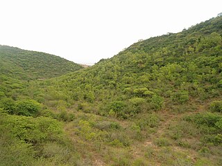
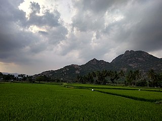
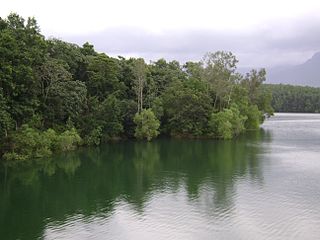
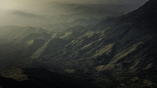
sitheri Hills (654.52km²) are one of the segments of Eastern Ghats of Tamil Nadu, within the geographical limit of 78°15’−78°45’E longitude and 11°44’−12°08’N latitude. The hill harbour various vegetation types such as the evergreen, the semi-evergreen, the riparian, the dry mixed deciduous, the dry deciduous scrub and the southern thorn scrub forests (Champion and Seth, 1968). The minimum and maximum temperature of the area is 19°C (in winter) and 40°C (in summer) respectively. The annual rainfall varies from 620 to 900mm and it received both northeast and southwest monsoons. The hills form a compact block consisting of several hill ranges, and contain tangled ridges and ravines running in the northeast and southwest directions, enclosing many narrow valleys (rivers), viz. Kallar, Varattar, Kambalai and Anaimaduvu. Topographically, the area is undulating with an altitude varying from 240 to 1266 m. The rocks on Chitteri hills are chiefly gneisses/granitic in composition. Soil is generally shallow and reddish-loam, varying in fertility and often mixed with gravel and boulders. Black soils are seldom found in the forests.
The Eastern Ghats are a discontinuous range of mountains along India's eastern coast. The Eastern Ghats run from the northern Odisha through Andhra Pradesh to Tamil Nadu in the south passing some parts of Karnataka and in the Wayanad region of Kerala. They are eroded and cut through by four major rivers of peninsular India, viz. Godavari, Mahanadi, Krishna, and Kaveri.
Tamil Nadu is one of the 29 states of India. Its capital and largest city is Chennai. Tamil Nadu lies in the southernmost part of the Indian subcontinent and is bordered by the union territory of Puducherry and the South Indian states of Kerala, Karnataka, and Andhra Pradesh. It is bounded by the Eastern Ghats on the north, by the Nilgiri Mountains, the Meghamalai Hills, and Kerala on the west, by the Bay of Bengal in the east, by the Gulf of Mannar and the Palk Strait on the southeast, and by the Indian Ocean on the south. The state shares a maritime border with the nation of Sri Lanka.
Monsoon is traditionally defined as a seasonal reversing wind accompanied by corresponding changes in precipitation, but is now used to describe seasonal changes in atmospheric circulation and precipitation associated with the asymmetric heating of land and sea. Usually, the term monsoon is used to refer to the rainy phase of a seasonally changing pattern, although technically there is also a dry phase. The term is sometimes incorrectly used for locally heavy but short-term rains, although these rains meet the dictionary definition of monsoon.
On 13 September 2011 at least 10 people have been reported killed and more than 70 injured when a passenger train from Chennai rammed into a stationary train near chitteri railway station close to Arakkonam, about 75km from here, late on Tuesday night.
On 11 April 2013, The Muzaffarpur-Yeswantpur Express train derailed around 6 am at Chitteri, Eleven coaches derailed in Tamil Nadu, killing one person and injuring 50 others. Six of these 50 people have suffered serious injuries.
This page is based on this Wikipedia article Text is available under the CC BY-SA 4.0 license; additional terms may apply. Images, videos and audio are available under their respective licenses.
Related Research Articles
In botany, an evergreen is a plant that has leaves throughout the year that are always green. This is true even if the plant retains its foliage only in warm climates, and contrasts with deciduous plants, which completely lose their foliage during the winter or dry season. There are many different kinds of evergreen plants, both trees and shrubs. Evergreens include:
The South Western Ghats montane rain forests are an ecoregion of southern India, covering the southern portion of the Western Ghats range in Karnataka, Kerala and Tamil Nadu, at elevations over 1000 meters. They are cooler and wetter than the lower-elevation South Western Ghats moist deciduous forests, which surround the montane rain forests.
The East Deccan dry evergreen forests are an ecoregion of southeastern India. The ecoregion includes the coastal region behind the Coromandel Coast on the Bay of Bengal, between the Eastern Ghats and the sea. It covers eastern Tamil Nadu, part of Puducherry and south eastern Andhra Pradesh.
The South Western Ghats moist deciduous forests is a tropical moist broadleaf forest ecoregion of southern India. It covers the southern portion of the Western Ghats range and the Nilgiri Hills between 250 and 1000 meters elevation in Kerala, Karnataka and Tamil Nadu states.
The Biligirirangana Hills, commonly called BR Hills, is a hill range situated in south-eastern Karnataka, at its border with Tamil Nadu in South India. The area is called Biligiriranganatha Swamy Temple Wildlife Sanctuary or simply BRT Wildlife Sanctuary. It is a protected reserve under the Wildlife Protection Act of 1972. Being at the confluence of the Western Ghats and the Eastern Ghats, the sanctuary is home to eco-systems that are unique to both the mountain ranges. The site was declared a tiger reserve in January 2011 by the Karnataka government, a few months after approval from India's National Tiger Conservation Authority.
Aanaimalai Tiger Reserve, earlier known as Indira Gandhi Wildlife Sanctuary and National Park (IGWLS&NP) and previously as Aanaimalai Wildlife Sanctuary, is a protected area located in the Aanaimalai Hills of Pollachi and Valparai taluks of Coimbatore District and Udumalaipettai taluk in Tiruppur District, Tamil Nadu, India. The Tamil Nadu Environment and Forests Department by a notification dated 27 June 2007, declared an extent of 958.59 km2 that encompassed the erstwhile IGWLS&NP or Aanaimalai Wildlife Sanctuary, as Aanaimalai Tiger Reserve under the Wildlife Protection Act, 1972. According to the National Tiger Conservation Authority, the Reserve presently includes a core area of 958.59 km2 and buffer/peripheral area of 521.28 km2 forming a total area of 1479.87 km2.
Marayur or Marayoor is a town in Idukki district of Kerala, India. It is located 42 kilometers north of Munnar on SH 17 connecting Munnar with Udumalpet, Tamil Nadu. Marayur is the only place in Kerala that has natural sandalwood forests. Ancient dolmens and rock paintings in Marayur date back to the Stone Age. In 1991 Marayur had a population of 9,590.
The Mudumalai National Park and Wildlife Sanctuary also a declared tiger reserve, lies on the northwestern side of the Nilgiri Hills, in Nilgiri District, about 150 kilometres (93 mi) north-west of Coimbatore city in Tamil Nadu. It shares its boundaries with the states of Karnataka and Kerala. The sanctuary is divided into five ranges – Masinagudi, Thepakadu, Mudumalai, Kargudi and Nellakota.
The term Malabar rainforests refers to one or more distinct ecoregions recognized by biogeographers:
the Malabar Coast moist forests formerly occupied the coastal zone to the 250 metre elevation
the South Western Ghats moist deciduous forests grow at intermediate elevations
the South Western Ghats montane rain forests cover the areas above 1000 metres elevation
The Lower Gangetic plains moist deciduous forests is a tropical moist broadleaf forest ecoregion of Bangladesh and eastern India. The ecoregion covers an area of 254,100 square kilometres (98,100 sq mi), covering most of Bangladesh and the Indian states of West Bengal, Bihar and Tripura, and extending into adjacent portions of Assam, Uttar Pradesh and Orissa states.
The Kalvarayan Hills are a major range of hills situated in the Eastern Ghats of the southern Indian state of Tamil Nadu. Along with the Pachaimalai, Alavaimalai, Javadi, and Shevaroy hills, they separate the Kaveri River basin to the south from the Palar River basin to the north. The hills range in height from 2000 feet to 3000 feet and extend over an area of 1095 square kilometres.
The Himalayan subtropical broadleaf forests is an ecoregion that extends from the middle hills of central Nepal through Darjeeling into Bhutan and also into the Indian State of Uttar Pradesh. It represents the east-west-directed band of subtropical broadleaf forest at an altitude of between 500 to 1,000 m along the Outer Himalayan Range, and includes several forest types traversing an east to west moisture gradient.
The Palani Hills Wildlife Sanctuary and National Park is a proposed protected area in Dindigul District, Tamil Nadu India. The park will be an upgrade and expansion of the 736.87 km2 (PRO) Palani (Kodaikanal) Wildlife Sanctuary which was to be established in 2008. The park includes about 36% of the 2,068 square kilometres (798 sq mi) in the Palani Hills. The park is located between latitude 10°7' - 10°28' N and longitude 77°16' - 77°46' E. Central location is 1.5 kilometres (0.93 mi) east northeast of Silver Cascade Waterfall and 4 kilometres (2.5 mi) E X NE of Kodaikanal Lake.
The Grizzled Squirrel Wildlife Sanctuary (GSWS), also known as Srivilliputhur Wildlife Sanctuary, was established in 1988 to protect the vulnerable grizzled giant squirrel. Occupying an area of 485.2 km2, it is bordered on the southwest by the Periyar Tiger Reserve and is one of the best preserved forests south of the Palghat Gap.
Phu Phra Bat Buabok is a forest park in Ban Phue District, Udon Thani Province, northeast Thailand.
The Peppara Wildlife Sanctuary is a wildlife sanctuary near Thiruvananthapuram in southern Kerala, India. It consists of the catchment area of the Karamana river, which originates from Chemmunjimottai, the tallest hill within the sanctuary. The sanctuary is named after the Peppara dam, commissioned in 1983 to augment the drinking water supply to Thiruvananthapuram city and suburban areas. Considering the ecological significance of the area, it was declared a sanctuary in 1983. The terrain is undulating with elevation ranging from 100 m to 1717 m. The area of the sanctuary is 75 km2 with tropical moist evergreen forests and myristica swamps. Peppara Wildlife Sanctuary is 44 kilometres (27 mi) by car from the nearest railway station, at Thiruvananthapuram, and 49 kilometres (30 mi) from the Thiruvananthapuram airport.
Phu Hin Rong Kla National Park is a national park located in the Loei, Phitsanulok and Phetchabun Provinces of Thailand. The protected area is located in the forested mountains of the Luang Prabang Range close to the border with Laos and is part of the Luang Prabang montane rain forests ecoregion.The park is the base of operations of the long fight of Thai combatant in communist war of Thailand.
The Melagiris are a range of hills on the Eastern Ghats, bound by the river Cauvery on the west. Melagiri contain an expanse of 1295 km2 of dry deciduous and semi-evergreen forests. It is an elephant country and contains two traditional elephant corridors. With the Bannerghatta National Park in the North east and Cauvery Wildlife Sanctuary in the south, the forest range stretches to sanctuaries of BR Hills and Sathyamangala and joins the tiger reserves of Nilgiri Biosphere. As the meeting point of the Western Ghats and Eastern Ghats, these forests form a vital link in the elephant corridors of South India, connecting the Bannerghatta National Park and the River Cauvery. It borders some of the prominent tiger sanctuaries of the south.
Sathyamangalam Wildlife Sanctuary and Tiger Reserve is a protected area and tiger reserve along the Western Ghats in the Erode District of the Indian state of Tamil Nadu. First declared as a wildlife sanctuary in 2008 and enlarged in 2011, it covers a forest area of 1,411.6 km2 (545.0 sq mi) and is the largest wildlife sanctuary in Tamil Nadu. In 2013, it became the fourth tiger reserve as a part of Project Tiger in the state of Tamil Nadu.
Sitheri (Sitteri) is a hill station in Dharmapuri district located in Tamil Nadu, India. Sitheri Hills are one of the segments of Eastern Ghats of Tamil Nadu. Which comes under the Pappireddipatti taluk. It is situated at an altitude of 1097.3 metres (3600 ft)The area comprises various vegetation
types such as the evergreen, semi-evergreen, riparian, dry deciduous scrub and southern thorn scrub forests. The minimum and
maximum temperature is 19 °C in winter and 40 °C in summer respectively. The average annual rainfall is 900 mm attained from both
northeast and southwest monsoons. Topographically, the area is undulating with an altitude varying from 240 to 1266 m.The total area of Sitheri village is found to be 400 km2 with a total population of 9045 as of 2010.
.