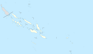
Solomon Islands is divided into nine provinces. The national capital, Honiara, on the island of Guadalcanal, is separately governed as the islands' Capital Territory.

The Choiseul Province is one of the nine provinces of Solomon Islands. It lies southeast of Bougainville (part of Papua New Guinea, west of Santa Isabel and north of Vella la Vella, Kolombangra & New Georgia. In the 2009 national census its population is 26,372.

British Solomon Islands Protectorate was first declared over the southern Solomons in 1893, when Captain Gibson R.N., of HMS Curacoa, declared the southern islands a British Protectorate. Other islands were subsequently declared to form part of the Protectorate over a period ending in 1900.

The Northern Solomons were the more northerly group of islands in the Solomon Islands archipelago over which Germany declared a protectorate in 1885. Initially the German Solomon Islands Protectorate included Choiseul, Santa Isabel, the Shortlands and Ontong Java Islands, but in 1900 these islands were transferred to the British Solomon Islands Protectorate. The largest of the Solomon Islands, Bougainville, continued under German administration until World War I when it fell to Australia, and after the war, it formally passed to Australian jurisdiction under a League of Nations mandate.

The National Parliament of Solomon Islands has 50 members, elected for a four-year term in 50 single-seat constituencies.
Fauro Island is an island of the Shortland Islands archipelago, located in the Western Province of the Solomon Islands, located at 6°55′S156°4′E. Along the center spine of the island are Mount Pauboleala with an elevation of 574', Mount Lalauka with an elevation of 517', and Sharp Peak with an elevation of 484'.
Jonathan Fiifii'i was a Kwaio at Ane'emae near Oloburi, Malaita, Solomon Islands. His father was Buumae and mother Dafua.

Balalae Island is an island of the Shortland Islands Group in the Western Province of the Solomon Islands.
Shortlands is a parliamentary constituency electing one representative to the National Parliament of Solomon Islands. It had a registered electorate of 2,556 in 2006. It is one of eight constituencies in Western Province and covers the Shortland Islands.

Sir George Gerea Dennis Lepping, GCMG, MBE served as the second Governor-General of the Solomon Islands from 7 July 1988 to 6 July 1994. Lepping is a native of the Shortland Islands of Western Province.
'Are'are was a single-member constituency of the Governing Council and Legislative Assembly of the Solomon Islands. Created in 1973 when the Governing Council was expanded from 17 to 24 seats, it was located on the island of Malaita. In the 1973 elections the seat was won by David Kausimae, who had been elected in the South Central Malaita constituency in the 1970 elections, defeating defeated Peter Kenilorea. It was abolished in 1976 and succeeded by East 'Are'are and West 'Are'are.
Central Solomons was a single-member constituency of the Legislative Council of the Solomon Islands. It was created in 1967 and abolished in 1970 when the Governing Council was created. Its sole elected member, John Plant Hoka stood for re-election in the Ngella/Savo/Russells constituency in the 1970 elections.

The Legislative Council (LegCo) was the legislature of the Solomon Islands between 1960 and 1970.
John Plant Hoka was a Solomon Islands politician.
East Guadalcanal is a single-member constituency of the National Parliament of Solomon Islands. Located on the island of Guadalcanal, it was established in 1970 when the Governing Council was created and the number of elected seats increased from 14 to 17.
Eastern Outer Islands was a single-member constituency of the Legislative Council, Governing Council and Legislative Assembly of the Solomon Islands between 1967 and 1976. It was succeeded by the First and Second Eastern Outer Islands constituencies, with the constituency's final MP, Moffat Bonunga, re-elected in the First constituency.


