Christianshavn is a neighbourhood in Copenhagen, Denmark. Part of the Indre By District, it is located on several artificial islands between the islands of Zealand and Amager and separated from the rest of the city centre by the Inner Harbour. It was founded in the early 17th century by Christian IV as part of his extension of the fortifications of Copenhagen. Originally, it was laid out as an independent privileged merchant's town with inspiration from Dutch cities but it was soon incorporated into Copenhagen proper. Dominated by canals, it is the part of Copenhagen with the most nautical atmosphere.

Islands Brygge station is a rapid transit station of the Copenhagen Metro in Copenhagen, Denmark. The first station on the M1 Line after its split from the M2 Line at Christianshavn, it is located in zone 1 in the northwestern section of the island of Amager.

Flintholm station is an S-train and Metro interchange junction station in Copenhagen, Denmark. It opened on 24 January 2004, and it is located in the west of Copenhagen where the Frederikssund S-train Line crosses the S-train Ring Line. It is located in fare zone 2.

Amagerbro station is a rapid transit station on the Copenhagen Metro, located in the Sundbyøster district of Copenhagen. It opened in 2002.

Fasanvej station is a rapid transit station on the Copenhagen Metro in Frederiksberg, Denmark. It was known as Solbjerg Station until 25 September 2006. The station opened 12 October 2003, and serves the M1 and M2 lines. It is located in fare zone 2.

Lindevang station is a rapid transit station on the Copenhagen Metro in Frederiksberg, Denmark. It serves the M1 and M2 lines. It is located where the Metro line crosses Dalgas Boulevard in Frederiksberg. It opened 12 October 2003. It is located in fare zone 2.

Bella Center station is a rapid transit station on the Copenhagen Metro. It is served by the M1 line. The station is elevated from ground level and opened on 19 October 2002. It is located in fare zone 3 and named after the Bella Center, a congress center located to the west of this station.

Femøren station is a rapid transit station on the Copenhagen Metro located in the Sundbyøster district of Copenhagen. It opened on 28 September 2007.

Kastrup station is a rapid transit station of the Copenhagen Metro, located in the Kastrup section of Tårnby. It opened on 28 September 2007.
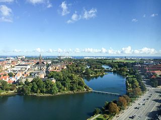
Christianshavns Vold is a former rampart which was part of the bastioned fortification ring which used to surround Copenhagen, Denmark. Running along the full south-eastern perimeter of Christianshavn and Holmen, it used to form a protective barrier towards the island of Amager. It consists of earthworks with 12 bastions and in front of it ran a moat, Stadsgraven, now forming a broad canal which separates Christianshavn from the rest of Amager. On the other side of Stadsgraven. on Amager, was a lower system of outworks called Christianshavns Enveloppe of which only the northern half survives. Along with Kastellet on the other side of the harbour, it is the only intact part of the fortification system.

Brøste House, also known as Potter House after its founder, Thomas Potter, a Scottish born industrialist, is a late 18th-century historic property at Overgaden Oven Vandet 10, overlooking Christianshavn Canal, in the Christianshavn neighbourhood of Copenhagen, Denmark. The building was listed in the Danish registry of protected buildings and places in 1918. It is now owned by Barfoed Group.
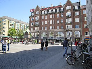
Christianshavns Torv is the central public square of the Christianshavn neighborhood in Copenhagen, Denmark. It is situated at the intersection of Torvegade and Christianshavn Canal, roughly at the center of the area.

Applebyes Plads is a triangular area located between Langebro Bridge and the southernmost portion of Christianshavn Canal at the southern tip of the Christianshavn neighbourhood in Copenhagen, Denmark. The area takes its name from Peter Applebye, Christian VI's rope maker, who ran his manufactury from the site in the late 18th century, although no buildings remain from that time. The Danish Sugar Factories' building along the waterfront dates from 1912 while the rest of the grounds have undergone residential redevelopment in later years.

Sankt Annæ Gade is a street in the Christianshavn district of Copenhagen, Denmark. It connects the main harbourfront at Asiatisk Plads in the west to Christianshavn Rampart in the east via the Snorrebroen bridge. Church of Our Saviour is located in the street.

The Women's Prison at Christianshavn in Copenhagen, Denmark, was a correctional facility which existed under various names from the mid 17th century until 1921. From 1870 it served as a women's prison. Earlier names included Børnehuset and Tugt- og Rasphuset. Its last building, which dated from 1861, was torn down in 1928 to make way for an expansion of Torvegade.

Torvegade is the central thoroughfare of Christianshavn in Copenhagen, Denmark, linking the city centre by way of Knippel Bridge with Amagerside Copenhagen at Christmas Møllers Plads. The street crosses Christianshavn Canal at Christianshavns Torv, the central square of the neighbourhood. The last section of the street runs on the embankment that across Stadsgraven.

Frørup is a village in central Denmark, located in Nyborg Municipality on the island of Funen in the Region of Southern Denmark. Frørup was a part of Ørbæk Municipality until 2007.
Sofiegade is a street in the Christianshavn neighbourhood of central Copenhagen, Denmark. It runs from Christianshavns Kanal in the northwest to Christianshavns Voldgade and Christianshavns Vold in the southeast, passing Dronningensgade and Prinsessegade on the way.

Amager Boulevard is a street on Amager in Copenhagen, Denmark. It begins at Langebro Bridge and initially follows Stadsgraven east to a Y-junction from where it continues inland to Amagerbrogade while the street Ved Stadsgraven continues along the water to the Christmas Møllers Plads.

The Andreas Bjørn House is a historic property located at the corner of Strandgade and Bådsmandsstræde in the Christianshavn neighbourhood of Copenhagen, Denmark. It was built for Andreas Bjørn in 1734 and listed on the Danish registry of protected buildings and places in 1918. A sugar refinery named Union House was from 1771 to 1811 located in a now demolished warehouse adjacent to the building by a group of British merchants and plantation owners from St. Croix in the Danish West Indies.