
Teesta River is a 414 km (257 mi) long river that rises in the Pauhunri Mountain of eastern Himalayas, flows through the Indian states of Sikkim and West Bengal through Rangpur, and enters the Bay of Bengal. It drains an area of 12,540 km2 (4,840 sq mi). In India, it flows through Mangan District, Gangtok District, Pakyong District, Kalimpong district, Darjeeling District, Jalpaiguri District, Cooch Behar districts and the cities of Rangpo, Jalpaiguri and Mekhliganj, Rangpur. It joins the Brahmaputra River at Phulchhari Upazila in Bangladesh. 305 km (190 mi) of the river lies in India and 109 km (68 mi) in Bangladesh. Teesta is the largest river of Sikkim and second largest river of West Bengal after the Ganges.
North Sikkim is a district of the Indian state of Sikkim. Its district headquarters is Mangan. It is the seventh least populous district in the country.

Lachung is a town and hill station in northeast Sikkim, India. It is located in the North Sikkim district near the border with Tibet. Lachung is at an elevation of about 9,600 feet (2,900 m) and at the confluence of the Lachen and Lachung Rivers, both tributaries of the River Teesta. The word Lachung means "small pass". The town is approximately 125 kilometres (78 mi) from the capital Gangtok.

The Lachen River is a tributary of the Teesta River in the state of Sikkim, India. It is one of the two main tributaries of the Teesta along with the Lachung River, which rise on opposite sides of the Donga Range in neighbouring Bhutan and converge in Chungthang in the North Sikkim district.

The Lachung River is a tributary of the Teesta River located in the East Indian state of Sikkim. It is a chief tributary of the Teesta, which is an important river in Sikkim along with Rangeet River. The village of Lachung is perched on the craggy bank of the river approximately 23 kilometres (14 mi) from Chungthang. It is at Chungthang where the Lachung and Lachen rivers converge and give rise to the Teesta. The river is 2,500 metres (8,200 ft) above sea level.

Chungthang is a town in Mangan District district in the Indian state of Sikkim. It is situated at the confluence of the Lachen and Lachung rivers, which combine to form the Teesta River. Located at a distance of 95 kilometres (59 mi) from the state capital Gangtok, the Indian Army has a major forward base with a medical centre in Chungthang.

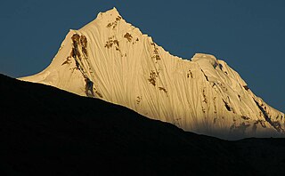
Gurudongmar Lake is one of the highest lakes in the world and in India, at an elevation of 5,430 m (17,800 ft) according to the Government of Sikkim. It is located in the Great Himalayas in the Mangan District in Indian state of Sikkim, and considered sacred by Buddhists, Sikhs and Hindus. The lake is named after Guru Padmasambhava—also known as Guru Rinpoche—founder of Tibetan Buddhism, who visited in the 8th century.

Singtam is a town which lies mostly in Gangtok District and partly in Pakyong District in the Indian state of Sikkim about 30 kilometres (19 mi) from the state capital Gangtok. The town lies on the banking of the rivers Teesta and Ranikhola, which join together just below the town. NH10 and NH510 meet in Singtam. The Indreni Bridge and Sherwani Bridge over the river Teesta are in the town. Singtam District Hospital, the district hospital of Pakyong District, lies at Golitar, Singtam.

Herona marathus, the pasha is a species of nymphalid butterfly found in India.

Amitabh Bachchan Falls (real name is Bhewma Falls) lies on the road connecting Chungthang to Yumthang Valley in Lachung, North Sikkim district of Sikkim. It has believed to have gotten the name Amitabh Bachchan Falls from the Bollywood star Amitabh Bachchan, who is very tall.
Mangan is the headquarter of the district of Mangan District in the Indian state of Sikkim. The town lying near River Teesta is connected to the capital Gangtok by a metalled road. Mangan District is the largest district of Sikkim in terms of area. The town lies in the geographic south of the district. After the opening up of the district, Mangan has witnessed a spurt in its economy, mostly due to organic farming. The town opens up the Tibetan Plateau. Mangan also serves the towns of Lachung, Chungthang and Lachen in the far north. Owing to its elevation, the town enjoys a temperate climate.
The 2011 Sikkim earthquake occurred with a moment magnitude of 6.9 and was centered within the Kanchenjunga Conservation Area, near the border of Nepal and the Indian state of Sikkim, at on Sunday, 18 September. The earthquake was felt across northeastern India, Nepal, Bhutan, Bangladesh and southern Tibet.
Shipgyer is a village in Chungthang subdivision, North Sikkim district, Sikkim, India. The Ministry of Home Affairs has given it a geographical code of 260862.
Tung is a village in the Chungthang subdivision of North Sikkim district in the north Indian state of Sikkim. The Ministry of Home Affairs has given it a geographical code of 260863.
Lachen Forest Block is a village in Chungthang subdivision, North Sikkim district, Sikkim, India. The Ministry of Home Affairs has given it a geographical code of 260864.
Thangu Forest Block is a village in Chungthang subdivision, North Sikkim district, Sikkim, India. The Ministry of Home Affairs has given it a geographical code of 260865.
Lachung Forest Block is a village in Chungthang subdivision, North Sikkim district, Sikkim, India. The Ministry of Home Affairs has given it a geographical code of 260866.

Chungthang subdivision is one of the two sub-districts of North Sikkim district, in the state of Sikkim, India. Chungthang is the headquarters. It contains nine census-designated villages:
Dikchu is a small town in the Gangtok District of the Indian state of Sikkim. The town lies at the confluence of the Dikchu River with the Teesta River and is the site of the 96 MW Dikchu River Hydroelectric Power Project as well as 510 MW Teesta V Hydroelectric Power Project. Dikchu is the last town of Gangtok District that lies on the North Sikkim Highway connecting Singtam to Chungthang, after crossing the town we enter Mangan District. Small market north of river Dikchu also lies on Mangan District.
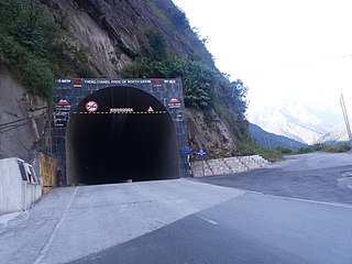
Theng Tunnel is a road tunnel on the Chungthang-Mangan (Gangtok-Chungthang) highway in North Sikkim. The 578 meters long tunnel is the longest tunnel in the state of Sikkim.

