
Gyalshing District or Geyzing District is a district of the Indian state of Sikkim. Its headquarter is Geyzing, also known as Gyalshing. The district is a favourite with trekkers due to the high elevations. Other important towns include Pelling and Yuksom. Local people also call it as Pallo-Sikkim and Sano-Sikkim commonly.
North Sikkim is a district of the Indian state of Sikkim. Its district headquarters is Mangan. It is the seventh least populous district in the country.

Namchi District is a district of the Indian state of Sikkim. Its headquarters is at Namchi.

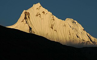
Lachung is a town and hill station in Mangan district in northeast Indian state of Sikkim. It is approx. 50 km Mangan town, the district headquarters. It is located in the Mangan district near the border with Tibet. Lachung is at an elevation of about 9,600 feet (2,900 m) and at the confluence of the Lachen and Lachung Rivers, both tributaries of the River Teesta. The word Lachung means "small pass". The town is approximately 125 kilometres (78 mi) from the capital Gangtok.

The Lachen River is a tributary of the Teesta River in the state of Sikkim, India. It is one of the two main tributaries of the Teesta along with the Lachung River, which rise on opposite sides of the Donga Range in neighbouring Bhutan and converge in Chungthang in the North Sikkim district.

The Lachung River is a tributary of the Teesta River located in the East Indian state of Sikkim. It is a chief tributary of the Teesta, which is an important river in Sikkim along with Rangeet River. The village of Lachung is perched on the craggy bank of the river approximately 23 kilometres (14 mi) from Chungthang. It is at Chungthang where the Lachung and Lachen rivers converge and give rise to the Teesta. The river is 2,500 metres (8,200 ft) above sea level.

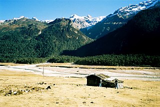
Chungthang is a town in Mangan district in the Indian state of Sikkim. It is located just 28 km from Mangan town, the district headquarters. It is situated at the confluence of the Lachen and Lachung rivers, which combine to form the Teesta River. Located at a distance of 95 kilometres (59 mi) from the state capital Gangtok, the Indian Army has a major forward base with a medical centre in Chungthang.
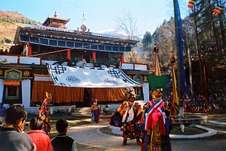
Lachung Monastery is a Nyingma Buddhist gompa in the Lachung Valley in Mangan district in Northeastern Indian state of Sikkim. It is approx. 50 km from Mangan town, the district headquarters. It was established in 1880.

Mangan is a town and the headquarter of the district of Mangan District in the Indian state of Sikkim. The town lying near River Teesta is connected to the capital Gangtok by a metalled road. Mangan District is the largest district of Sikkim in terms of area. The town lies in the geographic south of the district. After the opening up of the district, Mangan has witnessed a spurt in its economy, mostly due to organic farming. The town opens up the Tibetan Plateau. Mangan also serves the towns of Lachung, Chungthang and Lachen in the far north. Owing to its elevation, the town enjoys a temperate climate.
Shipgyer is a village in Chungthang subdivision, North Sikkim district, Sikkim, India. The Ministry of Home Affairs has given it a geographical code of 260862.
Tung is a village in the Chungthang subdivision of North Sikkim district in the north Indian state of Sikkim. The Ministry of Home Affairs has given it a geographical code of 260863.
Lachen Forest Block is a village in Chungthang subdivision, North Sikkim district, Sikkim, India. The Ministry of Home Affairs has given it a geographical code of 260864.
Thangu Forest Block is a village in Chungthang subdivision, North Sikkim district, Sikkim, India. The Ministry of Home Affairs has given it a geographical code of 260865.
Lachung Forest Block is a village in Chungthang subdivision, North Sikkim district, Sikkim, India. The Ministry of Home Affairs has given it a geographical code of 260866.
Chungthang Forest Block is a village in Chungthang subdivision, North Sikkim district, Sikkim, India. The Ministry of Home Affairs has given it a geographical code of 260867.
Mangan subdivision is one of the two sub-districts of North Sikkim district, in the state of Sikkim, India. Mangan is the headquarters.
Naga Forest Block is a village in Mangan subdivision, North Sikkim district, Sikkim, India. The Ministry of Home Affairs has given it a geographical code of 260910.
Mangan Forest Block is a village in Mangan subdivision, North Sikkim district, Sikkim, India. The Ministry of Home Affairs has given it a geographical code of 260911.

State Bank of Sikkim (SBS) is a state owned banking institution headquartered at Gangtok, Sikkim, India. In addition to banking services, State Bank of Sikkim handles treasury functions of the Sikkim State Government.
Makha is an important town lying on the bank of Teesta River in Gangtok district of Sikkim, India. Makha lies between Singtam and Dikchu.

