
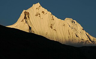
Sikkim is a state in Northeastern India. It borders the Tibet Autonomous Region of China in the north and northeast, Bhutan in the east, Province No. 1 of Nepal in the west and West Bengal in the south. Sikkim is also close to the Siliguri Corridor, which borders Bangladesh. Sikkim is the least populous and second smallest among the Indian states. Situated in the Eastern Himalaya, Sikkim is notable for its biodiversity, including alpine and subtropical climates, as well as being a host to Kangchenjunga, the highest peak in India and third highest on Earth. Sikkim's capital and largest city is Gangtok. Almost 35% of the state is covered by Khangchendzonga National Park – a UNESCO World Heritage Site.

Gangtok is a city, municipality, the capital and the largest populated place of the Indian state of Sikkim. It is also the headquarters of the Gangtok District. Gangtok is in the eastern Himalayan range, at an elevation of 1,650 m (5,410 ft). The city's population of 100,000 are from different ethnicities of Sikkimese people such as Indian Gorkhas, Bhutia and Lepchas. Within the higher peaks of the Himalayas and with a year-round mild temperate climate, Gangtok is at the centre of Sikkim's tourism industry.

The history of Sikkim, begins with indigenous Lepchas contact with early Tibetan settlers. Historically, Sikkim was a sovereign Monarchical State in the eastern Himalayas. Later a protectorate of India followed by merger with India and official recognition as a state of India. Lepchas were the main inhabitants as well as the Ruler of the land upto 1641. Lepchas are generally considered to be the first people, indigenous to Sikkim also includes Darjeeling.

West Sikkim is a district of the Indian state of Sikkim. Its headquarter is Geyzing, also known as Gyalshing. The district is a favourite with trekkers due to the high elevations. Other important towns include Pelling and Yuksom. Local people also call it as Pallo-Sikkim and Sano-Sikkim commonly.
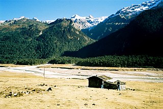
North Sikkim is a district of the Indian state of Sikkim. Its district headquarters is Mangan. It is the seventh least populous district in the country.

Namchi District is a district of the Indian state of Sikkim. Its headquarters is at Namchi.
The Kingdom of Sikkim, officially Dremoshong until the 1800s, was a hereditary monarchy in the Eastern Himalayas which existed from 1642 to 16 May 1975, when it merged with the Republic of India. It was ruled by Chogyals of the Namgyal dynasty.
The Sikkim Gold Cup, known as the Sikkim Governor's Gold Cup, is an Indian football tournament held in Sikkim and organized by Sikkim Football Association (SFA). Past champions include New Road Team of Nepal in 2007, Three Star Club of Nepal in 2008. and ONGC FC in 2010. Mohammedan S.C. became the champions for 2016 beating Jhapa XI 1–0 in the final.
Tung is a village in the Chungthang subdivision of North Sikkim district in the north Indian state of Sikkim. The Ministry of Home Affairs has given it a geographical code of 260863.

Chungthang subdivision is one of the two sub-districts of North Sikkim district, in the state of Sikkim, India. Chungthang is the headquarters. It contains nine census-designated villages:
Mangan subdivision is one of the two sub-districts of North Sikkim district, in the state of Sikkim, India. Mangan is the headquarters. It contains 46 census-designated villages:
Singchit is a village in Mangan subdivision, North Sikkim district, Sikkim, India. The Ministry of Home Affairs has given it a geographical code of 260870.
Lingthem is a village in Mangan subdivision, North Sikkim district, Sikkim, India. The Ministry of Home Affairs has given it a geographical code of 260875.
Lingdem is a village in Mangan subdivision, North Sikkim district, Sikkim, India. The Ministry of Home Affairs has given it a geographical code of 260876.
Chawang is a village in Mangan subdivision, North Sikkim district, Sikkim, India. The Ministry of Home Affairs has given it a geographical code of 260901.
Kabi is a village in Mangan subdivision, North Sikkim district, Sikkim, India. The Ministry of Home Affairs has given it a geographical code of 260906.
Tingda is a village in Mangan subdivision, North Sikkim district, Sikkim, India. The Ministry of Home Affairs has given it a geographical code of 260907.

The following outline is provided as an overview of and topical guide to Sikkim: