
William Butterfield was a British Gothic Revival architect and associated with the Oxford Movement. He is noted for his use of polychromy.

St Peter's College is one of the constituent colleges of the University of Oxford. Located on New Inn Hall Street, Oxford, United Kingdom, it occupies the site of two of the university's medieval halls dating back to at least the 14th century. The modern college was founded by Francis James Chavasse, former Bishop of Liverpool, opened as St Peter's Hall in 1929, and achieved full collegiate status as St Peter's College in 1961. Founded as a men's college, it has been coeducational since 1979.

A headstone, tombstone, or gravestone is a stele or marker, usually stone, that is placed over a grave. It is traditional for burials in the Christian, Jewish, and Muslim religions, among others. In most cases, it has the deceased's name, date of birth, and date of death inscribed on it, along with a personal message, or prayer, but may contain pieces of funerary art, especially details in stone relief. In many parts of Europe, insetting a photograph of the deceased in a frame is very common.

Chadlington is a village and civil parish in the Evenlode Valley about 3 miles (5 km) south of Chipping Norton, Oxfordshire. The village has four neighbourhoods: Brookend, Eastend, Greenend and Westend.

Steeple Aston is a village and civil parish on the edge of the Cherwell Valley, in the Cherwell District of Oxfordshire, England, about 12 miles (19 km) north of Oxford, 7 miles (11 km) west of Bicester, and 10 miles (16 km) south of Banbury. The 2011 Census recorded the parish population as 947. The village is 108 metres (354 ft) above sea level. The River Cherwell and Oxford Canal pass 1 mile (2 km) east of the village. The river forms part of the eastern boundary of the parish. The parish's southern boundary, 1⁄2 mile (800 m) south of the village, also forms part of Cherwell District's boundary with West Oxfordshire.

St Ebbe's is a Church of England parish church in central Oxford. The church is within the conservative evangelical tradition and participates in the Anglican Reform movement. It has members from many nations, many of whom are students at Oxford University. The rector is Vaughan Roberts who is also an author and conference speaker.

St Mary's Church, Handsworth, also known as Handsworth Old Church, is a Grade II* listed Anglican church in Handsworth, Birmingham, England. Its ten-acre (4 hectare) grounds are contiguous with Handsworth Park. It lies just off the Birmingham Outer Circle, and south of a cutting housing the site of the former Handsworth Wood railway station. It is noteworthy as the resting place of famous progenitors of the industrial age, and has been described as the "Cathedral of the Industrial Revolution".

Alvescot is a village and civil parish about 1+1⁄2 miles (2.4 km) south of Carterton, Oxfordshire, England. The 2011 Census recorded the parish's population as 472.

St Martin's Church in Bladon near Woodstock, Oxfordshire, England, is the Church of England parish church of Bladon-with-Woodstock. It is also the mother church of St Mary Magdalene at Woodstock, which was originally a chapel of ease. It is best known for the graves of the Spencer-Churchill family, including Sir Winston Churchill, in its churchyard.
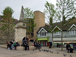
Bonn Square in Oxford, England, is named after the German city of Bonn with which Oxford is twinned. It is close to the original west gate of the city of Oxford, where the Westgate Shopping Centre is now located. To the east is Queen Street, a shopping street. New Inn Hall Street leads north from near here. Oxford Castle and the old Oxford Prison are also nearby, now converted into a hotel and restaurants.

Cuddesdon is a mainly rural village and former civil parish, now in the parish of Cuddesdon and Denton, in the South Oxfordshire district, in the county of Oxfordshire, England. centred 5.5 miles (9 km) ESE of Oxford. It has the largest Church of England clergy training centre, Ripon College Cuddesdon. Residents number approximately 430 in Cuddesdon's nucleated village centre and about 70 in the hamlets of Denton and Chippinghurst.
New Inn Hall Street is a street in central Oxford, England, and is one of Oxford's oldest streets. It is a shopping street running north–south parallel and to the west of Cornmarket Street, with George Street to the north and Bonn Square at the west end of Queen Street to the south. St Michael's Street leads off the street to the east near the northern end. Shoe Lane to the east leads to the Clarendon Centre, a modern shopping centre.

Tetsworth is a village and civil parish about 3 miles (5 km) south of Thame in Oxfordshire. Its Parish Council is made up of six elected Councillors. The estimated population in 2018 was 752 persons. According to the Council, business included the Zioxi educational furniture plant, the Swan antiques centre and some nearby equestrian and agricultural enterprises. The village no longer had a post office or many retail operations, but retained its "church, primary school, village hall, sports on the village green, and village pub and restaurant".

Brightwell Baldwin is a village and civil parish in Oxfordshire, about 4+1⁄2 miles (7 km) northeast of Wallingford. It was historically in the Hundred of Ewelme and is now in the District of South Oxfordshire. The 2011 Census recorded the parish's population as 208. The parish is roughly rectangular, about 2+1⁄2 miles (4 km) long north–south and about 1+1⁄4 miles (2 km) wide east–west. In 1848 the parish covered an area of 1,569 acres (635 ha). The B4009 road linking Benson and Watlington forms part of the southern boundary of the parish. The B480 road linking Oxford and Watlington forms a small part of its northern boundary. Rumbolds Lane forms much of its western boundary. For the remainder the parish is bounded largely by field boundaries.
The Tirah Memorial is a war memorial in Bonn Square, Oxford, England. It commemorates soldiers of the 2nd Battalion Oxfordshire Light Infantry who died in 1897–98 on the Tirah Expedition and Punjab Frontier Campaign to suppress rebel tribes on the North West Frontier of British India.
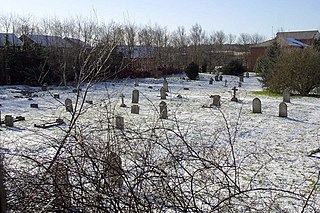
Osney Cemetery is a disused Church of England cemetery in Osney, west Oxford, England. Its entrance is in Osney Lane, which runs off the south end of Mill Street, south of Botley Road and near the site of Osney Abbey. It borders the Cherwell Valley Line railway a short distance south of Oxford railway station.

St Clement's Church is an evangelical Church of England parish church situated just to the east of central Oxford, England.
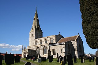
St Peter's Church is a Grade I listed Anglican parish church dedicated to Saint Peter, in Ropsley, Lincolnshire, England. The church is 5 miles (8 km) east from Grantham, and in the South Kesteven Lincolnshire Vales. St Peter's is in the ecclesiastical parish of Ropsley, and is part of the North Beltisloe Group of churches in the Deanery of Beltisloe, and the Diocese of Lincoln.


