
Torbay is a borough and unitary authority in Devon, south west England. It is governed by Torbay Council and consists of 62.87 square kilometres (24.27 sq mi) of land, including the resort towns of Torquay, Paignton and Brixham, located on east-facing Tor Bay, part of Lyme Bay on the English Channel. A popular tourist destination, Torbay's sandy beaches, mild climate and recreational and leisure attractions have given rise to its nickname of the "English Riviera".
Fairlight Glen lies about 2 miles (3.2 km) east of the fishing port of Hastings and 1.5 miles (2.4 km) west of the small village of Fairlight Cove on the East Sussex coast. It is a wooded area forming part of the Hastings Country Park Nature Reserve and leading down to Covehurst Bay. This is a naturist beach, but is shared by non-naturist visitors. The name Covehurst Bay is not normally used for the beach, but is marked on OS maps.

Paignton is a seaside town on the coast of Tor Bay in Devon, England. Together with Torquay and Brixham it forms the borough of Torbay which was created in 1998. The Torbay area is a holiday destination known as the English Riviera. Paignton's population in the United Kingdom Census of 2011 was 49,021. It has origins as a Celtic settlement and was first mentioned in 1086. It grew as a small fishing village and a new harbour was built in 1847. A railway line was opened to passengers in 1859 creating links to Torquay and London. As its population increased, it merged with the villages of Goodrington and Preston. Paignton is around 25 miles (40 km) north east of Plymouth and 20 miles (32 km) south of Exeter, and has the fourth largest population in Devon.

The Dartmouth Steam Railway, formerly known as the Paignton and Dartmouth Steam Railway, is a 6.7-mile (10.8 km) heritage railway on the former Great Western Railway branch line between Paignton and Kingswear in Devon, England. Much of the railway's business is from summer tourists from the resorts of Torbay, who travel to Kingswear, where the Dartmouth Passenger Ferry takes them across the River Dart to Dartmouth.

The Riviera Line is the railway between the city of Exeter, towns Dawlish, Teignmouth, and the "English Riviera" resorts of Torbay in Devon, England. Its tracks are shared with the Exeter to Plymouth Line along the South Devon sea wall. It is part of the Network Rail Route 12.

Church Ope Cove is a small secluded beach on the sheltered eastern side of the Isle of Portland in Dorset, southern England and is part of the Jurassic Coast. It is found close to the village of Wakeham. The beach has many unusual features for the Isle of Portland. The beach used to be sandy, but quarry debris now covers the sand, and has been worn into rounded pebbles. The pebbles cover a small stream which runs to the sea, which is one of the few active streams remaining on the Isle of Portland.

Treyarnon is a hamlet west of St Merryn in Cornwall, England, UK near Padstow. Treyarnon Beach is a small beach nearby with a caravan park, Youth Hostel and café.

The East Coast Trail (ECT) is a long-distance coastal footpath located in the Canadian province of Newfoundland and Labrador. It is a developed trail over 336 kilometres (209 mi) long, creation of which began in 1994. It is made up of 25 linked wilderness paths and passes through more than 30 communities. It was named one of the best adventure destinations by National Geographic in 2012 and is extended and improved yearly.
The Dartmouth and Torbay Railway was a broad gauge railway linking the South Devon Railway branch at Torquay with Kingswear in Devon, England. It was operated from the outset by the South Devon Railway.

The A379 is a road in the English county of Devon. It links points on the edges of that county's two principal cities, Exeter and Plymouth, by an indirect and largely coastal route. The A38 provides a faster and more direct inland route between Exeter and Plymouth, whilst the A380 provides a similarly faster route between Exeter and the Torbay area. However the A379 serves many small coastal communities and ports along the coast. The indented nature of the South Devon coast means that the road is usually out of sight of the sea, but the many rivers and estuaries are crossed by bridges and, in one case, a cable ferry.
Churston Ferrers Grammar School is a selective coeducational Grammar School with Academy status, situated in the village of Galmpton in Torbay, South Devon, England. It is also a specialist Humanities College. Year 7 annual intake is approximately 130 pupils.
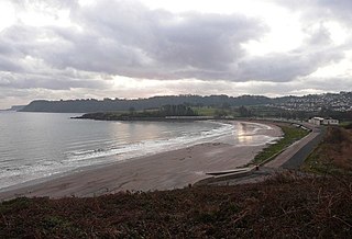
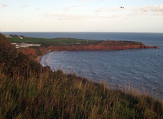
Broadsands is a beach on the coast of Torbay in South Devon, England. It is also the name of an area of housing inland from the beach, in the Churston Ferrers part of Torbay between Paignton and Brixham.

Galmpton is a semi-rural village in Torbay, in the ceremonial county of Devon, England. It is located in the ward of Churston-with-Galmpton and the historic civil parish of Churston Ferrers, though some areas historically considered parts of Galmpton, such as Greenway and Galmpton Creek, are situated in the Devon borough of South Hams.

St Oswald's Bay is located near Lulworth on the Jurassic Coast in Dorset, England.
Jordan Hill is located near the coast close to the village of Preston, just to the east of Weymouth, Dorset, England. The hill leads down to Furzy Cliff on the coast to the south. Close by to the east is Bowleaze Cove. The hill figure of the Osmington White Horse can be seen from the hill to the north. There are also views across Bowleaze Cove from the hill and nearby public footpaths. The hill is a short detour from the South West Coastal Path National Trail.
Straight Point is a coastal region, forming a headland, between Exmouth and Budleigh Salterton in Devon on the south coast of England.
Broadsands Beach is the marketing name given to a small cove located in Watermouth, originally known as Broadstrands Beach, North Devon. It is owned by Watermouth Valley Camping Park. It is accessed by 220 cliff steps from The Old Ilfracombe to Combe Martin Coast Road.

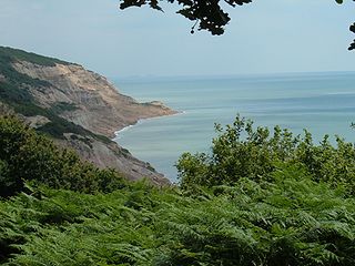
Elberry Cove, also known as Elbury Cove, is a shingle beach surrounded by woodland and fields, that lies between Brixham and Paignton in Devon, England. It is important for its eelgrass beds, breeding grounds for native seahorses, as well as mussels that are farmed in the waters nearby. It is on the South West Coast Path.

Churston Woods is an area of semi-ancient woodland near the village of Churston Ferrers and the town of Brixham. The woodland is made up of two main sections called The Grove and Ball Copse, both of which are owned by Torbay Council and managed by Torbay Coast and Countryside Trust.
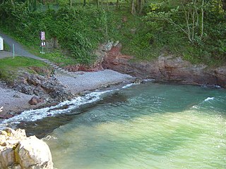
Fishcombe Cove is a small shingle beach on the south-west coast of England, on the outskirts of Brixham. The beach is surrounded by woodland, and an entrance to Churston Woods is located above Fishcombe Cove. It is important for its eelgrass beds, breeding grounds for native seahorses. It is on the South West Coast Path.
