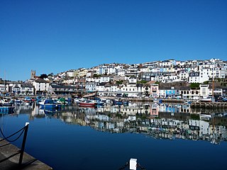
Brixham is a fishing town and civil parish in the district of Torbay in the county of Devon, in the south-west of England. Brixham is at the southern end of Torbay, across the bay from Torquay, and fishing and tourism are the major industries of the town. At the time of the 2011 census it had a population of 16,693.

Torbay is a borough and unitary authority in Devon, south west England. It is governed by Torbay Council and consists of 62.87 square kilometres (24.27 sq mi) of land, including the resort towns of Torquay, Paignton and Brixham, located on east-facing Tor Bay, part of Lyme Bay on the English Channel. A popular tourist destination, Torbay's sandy beaches, mild climate and recreational and leisure attractions have given rise to its nickname of the "English Riviera".

Paignton is a seaside town on the coast of Tor Bay in Devon, England. Together with Torquay and Brixham it forms the borough of Torbay which was created in 1998. The Torbay area is a holiday destination known as the English Riviera. Paignton's population in the United Kingdom Census of 2011 was 49,021. It has origins as a Celtic settlement and was first mentioned in 1086. It grew as a small fishing village and a new harbour was built in 1847. A railway line was opened to passengers in 1859 creating links to Torquay and London. As its population increased, it merged with the villages of Goodrington and Preston. Paignton is around 25 miles (40 km) north east of Plymouth and 20 miles (32 km) south of Exeter, and has the fourth largest population in Devon.

The South West Coast Path is England's longest waymarked long-distance footpath and a National Trail. It stretches for 630 miles (1,014 km), running from Minehead in Somerset, along the coasts of Devon and Cornwall, to Poole Harbour in Dorset. Because it rises and falls with every river mouth, it is also one of the more challenging trails. The total height climbed has been calculated to be 114,931 ft (35,031 m), almost four times the height of Mount Everest. It has been voted 'Britain's Best Walking route' twice in a row by readers of The Ramblers' Walk magazine, and regularly features in lists of the world's best walks.

The River Camel is a river in Cornwall, United Kingdom. It rises on the edge of Bodmin Moor and with its tributaries its catchment area covers much of North Cornwall. The river flows into the eastern Celtic Sea between Stepper Point and Pentire Point having covered about 30 miles, making it the second longest river wholly in Cornwall. The river is tidal upstream to Egloshayle and is popular for sailing, birdwatching and fishing. The name Camel comes from the Cornish language for 'the crooked one', a reference to its winding course. Historically the river was divided into three named stretches. Heyl was the name for the estuary up to Egloshayle, the River Allen was the stretch between Egloshayle and Trecarne, whilst the Camel was reserved for the stretch of river between its source and Trecarne.

The Dartmouth Steam Railway, formerly known as the Paignton and Dartmouth Steam Railway, is a 6.7-mile (10.8 km) heritage railway on the former Great Western Railway branch line between Paignton and Kingswear in Devon, England. Much of the railway's business is from summer tourists from the resorts of Torbay, who travel to Kingswear, where the Dartmouth Passenger Ferry takes them across the River Dart to Dartmouth.

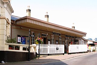
Churston railway station is on the Dartmouth Steam Railway, a heritage railway in Torbay, Devon, England. It is situated beside the main road to Brixham and close to the villages of Churston Ferrers and Galmpton.
The Dartmouth and Torbay Railway was a broad gauge railway linking the South Devon Railway branch at Torquay with Kingswear in Devon, England. It was operated from the outset by the South Devon Railway.
The Torbay and Brixham Railway was a 7 ft broad gauge railway in England which linked the Dartmouth and Torbay Railway at Churston railway station, Devon with the important fishing port of Brixham. It was a little over two miles long. Never more than a local branch line, it closed in 1963.

The South Devon Area of Outstanding Natural Beauty (AONB) covers 337 square kilometres, including much of the South Hams area of Devon and the rugged coastline from Jennycliff Bay to Elberry Cove near Brixham. The purpose of an Area of Outstanding Natural Beauty is to conserve and enhance the area's natural beauty. In South Devon this includes: undeveloped coastline, estuaries, geological and geomorphological features, expansive panoramic views, ancient agricultural field pattern, Devon banks, areas of high tranquility, dark night skies and natural nightscapes, historic features, green lanes, well known cultural associations, picturesque villages and hamlets. South Devon AONB was formally designated in August 1960 under the National Parks and Access to the Countryside Act 1949. The highest point in the AONB is Blackdown Camp at 199 metres above sea level.
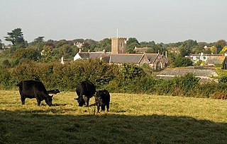
Churston Ferrers is an area and former civil parish, in the borough of Torbay, Devon, England, situated between the south coast towns of Paignton and Brixham. Today it is administered by local government as the Churston-with-Galmpton ward of the Torbay unitary authority. It contains the coastal village of Churston, the now larger village of Galmpton and the Broadsands area.
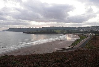
Broadsands is a beach on the coast of Torbay in South Devon, England. It is also the name of an area of housing inland from the beach, in the Churston Ferrers part of Torbay between Paignton and Brixham.

Galmpton is a semi-rural village in Torbay, in the ceremonial county of Devon, England. It is located in the ward of Churston-with-Galmpton and the historic civil parish of Churston Ferrers, though some areas historically considered parts of Galmpton, such as Greenway and Galmpton Creek, are situated in the Devon borough of South Hams.

Gribbin Head is a promontory on the south coast of Cornwall, England, UK, owned and managed by the National Trust. It separates St Austell Bay from the estuary of the River Fowey and is marked by a large tower used to aid navigation of ships approaching the local harbours. The nearest town is Fowey. The western point of the headland is called Little Gribbin.

North Devon's Biosphere Reserve is a UNESCO biosphere reserve in North Devon. It covers 55 square miles (140 km2) and is centred on Braunton Burrows, the largest sand dune system (psammosere) in England. The boundaries of the reserve follow the edges of the conjoined catchment basin of the Rivers Taw and the Torridge and stretch out to sea to include the island of Lundy. The biosphere reserve is primarily lowland farmland, and includes many protected sites including 63 Sites of Special Scientific Interest which protect habitats such as culm grassland and broadleaved woodlands. The most populous settlements in its buffer area are Barnstaple, Bideford, Northam, Ilfracombe, and Okehampton.

London Bridge is a natural arch on the coast of Torquay in Devon, England.
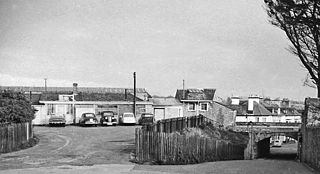
Brixham railway station was a railway station on the Torbay and Brixham Line, serving the town of Brixham, in Devon. The station opened in 1868 and closed in 1963. The station was subsequently demolished and the site was developed as a housing estate.

A statue of William III, also known as the Prince of Orange statue, stands in Brixham, Devon, England. It commemorates the landing of William of Orange and his army at the town on 5 November 1688. The monument has been a Grade II listed building since 1949.
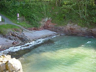
Fishcombe Cove is a small shingle beach on the south-west coast of England, on the outskirts of Brixham. The beach is surrounded by woodland, and an entrance to Churston Woods is located above Fishcombe Cove. It is important for its eelgrass beds, breeding grounds for native seahorses. It is on the South West Coast Path.
Churston Cove is a cove with a sand and shingle beach on the outskirts of Brixham, surrounded by cliffs and wooded hillsides. An entrance to Churston Woods is located at the back of the cove. There is a steep path leading down to the beach which also passes through Churston Woods. It is on the South West Coast Path.


