The History of Equatorial Guinea is marked by centuries of colonial domination by the Portuguese, British and Spanish empires, and by the local kingdoms.
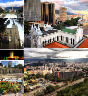
Caracas, officially Santiago de León de Caracas, is the capital and largest city of Venezuela, and centre of the Greater Caracas Area. Caracas is located along the Guaire River in the northern part of the country, following the contours of the narrow Caracas Valley on the Venezuelan coastal mountain range. Terrain suitable for building lies between 760 and 1,140 m above sea level, although there is some settlement above this range. The valley is close to the Caribbean Sea, separated from the coast by a steep 2,200-metre-high (7,200 ft) mountain range, Cerro El Ávila; to the south there are more hills and mountains. The Metropolitan Region of Caracas has an estimated population of 4,923,201.

Michoacán, formally Michoacán de Ocampo, officially the Free and Sovereign State of Michoacán de Ocampo, is one of the 31 states which, with the Federal District, comprise the 32 Federal Entities of Mexico. The State is divided into 113 municipalities and its capital city is Morelia. The city was named after José María Morelos, one of the main heroes of the Mexican War of Independence.

Florianópolis is the capital and second largest city of the state of Santa Catarina, in the South region of Brazil. The city encompasses Santa Catarina Island and surrounding small islands, as well as part of the mainland. It has a population of 477,798, according to the 2016 IBGE population estimate, the second most populous city in the state, and the 47th in Brazil. The metropolitan area has an estimated population of 1,111,702, the 21st largest in the country. The city is known for having the country's third highest Human Development Index score among all Brazilian cities (0.847). The city is considered safe by Brazilian standards. In 2014, Florianópolis had the second-lowest incidence of murders of Brazilian capitals.

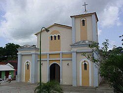
Coro is the capital of Falcón State and the oldest city in the west of Venezuela. It was founded on July 26, 1527 by Juan de Ampíes as Santa Ana de Coro. It is established at the south of the Paraguaná Peninsula in a coastal plain, flanked by the Médanos de Coro National Park to the north and the sierra de Coro to the south, at a few kilometers from its port in the Caribbean Sea at a point equidistant between the Ensenada de La Vela and Golfete de Coro.

Sisal is a seaport town in Hunucmá Municipality in the state of Yucatán, Mexico. It was the principal port of Yucatán during the henequen boom, later overshadowed when the more modern port of Progreso was built to the east. It lent its name to the agave-derived sisal fiber which was shipped through it.

Zihuatanejo, or Ixtapa-Zihuatanejo, is the fourth-largest city in the Mexican state of Guerrero. Politically the city belongs to the municipality of Zihuatanejo de Azueta in the western part of Guerrero, but both are commonly referred to as Zihuatanejo. It is on the Pacific Coast, about 240 km northwest of Acapulco, and belongs to a section of the Mexican Pacific Coast known as the Costa Grande. This town has been developed as a tourist attraction along with the modern tourist resort of Ixtapa, 5 km (3.1 mi) away. However, Zihuatanejo has kept its traditional town feel. The town is located on a well-protected bay which is popular with private boat owners during the winter months.
Ilhéus is a major city located in the southern coastal region of Bahia, Brazil, 211 km south of Salvador, the state's capital. The city was founded in 1534 as Vila de São Jorge dos Ilhéus and is known as one of the most important tourism centers of the northeast of Brazil.

Barcelona is the capital of Anzoátegui State, Venezuela and was founded in 1671. Together with Puerto La Cruz, Lecheria and Guanta, Barcelona forms one of the most important urban areas of Venezuela with a population of approximately 950,000.

Itacaré is a municipality in the cocoa zone of the state of Bahia in Brazil, south of Salvador.

Ocumare de la Costa is a small coastal town and the capital of the Ocumare de la Costa de Oro Municipality, located 25 miles north of Aragua, Venezuela. Called simply Ocumare, the colonial town sits at the skirts of the Venezuelan Coastal Range, adding the peculiar natural elements of the Henri Pittier National Park. Production of cocoa and fishing are the main industries in Ocumare. The valley leads into the Caribbean Sea, making Ocumare's beaches an important touristic area in the country.

Río Caribe is a colorful fishing town located 22 kilometers from Carúpano, Sucre State, in Eastern Venezuela. It is the capital city of the Arismendi municipality.

Soconusco is a region in the southwest corner of the state of Chiapas in Mexico along its border with Guatemala. It is a narrow strip of land wedged between the Sierra Madre de Chiapas mountains and the Pacific Ocean. It is the southernmost part of the Chiapas coast extending south from the Ulapa River to the Suchiate River, distinguished by its history and economic production. Abundant moisture and volcanic soil has always made it rich for agriculture, contributing to the flowering of the Mokaya and Olmec cultures, that were based on Theobroma cacao and rubber of Castilla elastica.

The Captaincy General of Venezuela also known as the Kingdom of Venezuela was an administrative district of colonial Spain, created on September 8, 1777, through the Royal Decree of Graces of 1777, to provide more autonomy for the provinces of Venezuela, previously under the jurisdiction of the Audiencia of Santo Domingo and then the Viceroyalty of New Granada. It established a unified government in political (governorship), military, fiscal (intendancy) and judicial (audiencia) affairs. Its creation was part of the Bourbon Reforms and laid the groundwork for the future nation of Venezuela, in particular by orienting the province of Maracaibo towards the province of Caracas.
The Royal Guipuzcoan Company of Caracas was a Spanish Basque trading company in the 18th century, operating from 1728 to 1785, which had a monopoly on Venezuelan trade. It was renamed in 1785 the Royal Philippine Company.

North Halmahera Regency is a regency of North Maluku Province, Indonesia. It was declared a Regency on 31 May 2003. The capital town of the regency lies at the port of Tobelo. The Regency, which has been considerably reduced by the separation of Tidore and of Morotai Island, now covers an area of 3,896.9 square kilometres (1,504.6 sq mi) and as at the 2010 Census had a population of 161,847 people. The latest official estimate was 177,980. The principal settlements are Tobelo, Kao and Galela. The area is noted for its white beaches and coral reefs.
Spanish expeditions led by Columbus and Alonso de Ojeda reached the coast of present-day Venezuela in 1498 and 1499. The first colonial exploitation was of the pearl oysters of the "Pearl Islands". Spain established its first permanent South American settlement in the present-day city of Cumaná in 1522, and in 1577 Caracas became the capital of the Province of Venezuela. There was also for a few years a German colony at Klein-Venedig.

Tourism in Venezuela has been developed considerably for decades, particularly because of its geographical position, the variety of landscapes, the richness of plant and wildlife, the artistic expressions and the privileged tropical climate of the country, which affords each region throughout the year. Since 2013 the country is having a very severe economical crisis affecting the tourism all over the country.

Barlovento is a sub-region of Miranda state, Venezuela. During Spanish colonization of the Americas, Barlovento was developed as estate owners founded cacao haciendas. The work on the estates was done by African slaves brought from what is now the Republic of the Congo, Democratic Republic of the Congo and Angola. These people were from the Kingdom of Kongo and Kingdom of Loango. There were also Yoruba slaves.