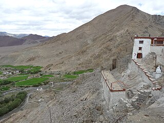
Ladakh is a region administered by India as a union territory and constitutes an eastern portion of the larger Kashmir region that has been the subject of a dispute between India and Pakistan since 1947 and India and China since 1959. Ladakh is bordered by the Tibet Autonomous Region to the east, the Indian state of Himachal Pradesh to the south, both the Indian-administered union territory of Jammu and Kashmir and the Pakistan-administered Gilgit-Baltistan to the west, and the southwest corner of Xinjiang across the Karakoram Pass in the far north. It extends from the Siachen Glacier in the Karakoram range to the north to the main Great Himalayas to the south. The eastern end, consisting of the uninhabited Aksai Chin plains, is claimed by the Indian Government as part of Ladakh, but has been under Chinese control.

Likir is a village and headquarter of eponymous Subdivision in the Leh district of Ladakh, India. It is located in the Likir tehsil, in the Ladakh region. Khalatse is a nearby trekking place.

Alchi is a village in the Leh district of Ladakh, India. It is located in the Likir tehsil, on the banks of the Indus River 70 km downstream from the capital Leh. Unlike the other gompas in Ladakh, Alchi is situated on lowland, not on a hilltop.

Upshi is a village and road junction on the Leh-Manali Highway in the union territory of Ladakh in India. It is located 47 km (29 mi) to the southeast of Leh along the Indus river valley and Tanglang La on the Leh-Manali highway. Gya is also to the south.

Nimo or Nyemo is a village and the headquarters of an eponymous community development block in the Leh district of Ladakh, India. It is located in the Leh tehsil, 35 km from Leh.

Nyoma is a principal village of southern Ladakh in India, the headquarters of an eponymous subdivision, tehsil, community development block and Indian Air Force Base in the Leh district. It is located on the bank of the Indus river after its 90-degree bend near Dungti east of Nyoma and before the valley narrows to a gorge near Mahe northwest of Nyoma. The Nyoma tehsil and subdivision cover all of southern Ladakh, including the Rupshu plains south of Nyoma, the Indus valley of Skakjung north of Nyoma, and the Hanle valley. Nyoma gompa, a Buddhist monastery, is located on the hill slope north of the village.

Ladakh Autonomous Hill Development Council, Kargil, is one among the two Autonomous District Councils of Ladakh union territory. LAHDC Kargil administers the Kargil District of Ladakh, India.

The Chutak Hydroelectric Plant is a run-of-the-river power project on the Suru River in Kargil district in the Indian union territory of Ladakh. The barrage of the project is at Sarze village and the powerhouse is located on the right bank of the Suru near Chutak village. The project construction began on 23 September 2006, and the first three generators were commissioned in November 2012. The fourth was commissioned in January 2013.
Kharnak is a village in the Leh district of Ladakh, India. It is located in the Nyoma tehsil.
Hemis-Shukpachan or Hemishok Pachan is a village in the Leh district of Ladakh, India. It is located in the Likir tehsil. Alternative transliterations of the village's name include Hemmis Shyk Pachan and Hemis Shukpachan.
Changa is a village in the Leh district of Ladakh, India. It is located in the Kharu tehsil, on the bank of the Indus River.

Gya or Gia is a village in the Leh district of Ladakh in India. It is located in the Kharu tehsil, off the Leh–Manali Highway, close to Tso Kar.
Umla is a village in the Leh district of Ladakh, India. It is located in the Likir tehsil.
Himya is a village in the Leh district in the Indian union territory of Ladakh. It is located in the Nyoma tehsil.
Miru or Meroo is a village in the Leh district of Ladakh, India. It is located in the Kharu tehsil. The Leh–Manali Highway passes through Miru.
Kharoo is a village in the Leh district in the union territory of Ladakh, India. It is located in the Kharu tehsil.
Suspol, also spelled Saspol, is a village and eponymous tehsil headquarter in the Leh district of Ladakh in India.
Panamic or Panamik is a village in the Leh district of Ladakh in India. It is located in the Nubra tehsil. Hot sulphur springs are found in the village. Panamik is a contraction of སྤང་ན་ཆུ་མིག་ 'Spang na Chumik', meaning 'the spring in the meadows'.

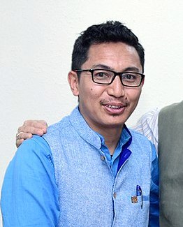
Jamyang Tsering Namgyal is an Indian politician and was a Member of Parliament from Ladakh, India's largest parliamentary seat geographically. Namgyal was elected, on 9 November 2018, to be the youngest and 8th Chief Executive Councillor (CEC) of Ladakh Autonomous Hill Development Council, Leh. He belongs to the Bharatiya Janata Party (BJP).
Shyok or Shayok is a village on the bank of the Shyok River in Durbuk tehsil of Leh district in Ladakh, India. It is located at the southern tip of the V-shaped course of the Shyok River, where the Tangtse river joins it from the left. Historically, the winter caravan route from Leh to Yarkand passed through the village. In modern times, India's strategic road to its border post at Daulat Beg Oldi uses the same route.


