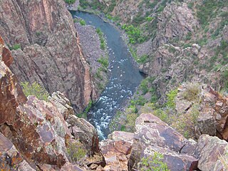
The Uncompahgre River is a tributary of the Gunnison River, approximately 75 mi (121 km) long, in southwestern Colorado in the United States. Lake Como at 12,215 ft (3723m) in northern San Juan County, in the Uncompahgre National Forest in the northwestern San Juan Mountains is the headwaters of the river. It flows northwest past Ouray, Ridgway, Montrose, and Olathe and joins the Gunnison at Confluence Park in Delta.

The North Fork Gunnison River is a tributary of the Gunnison River, 33.5 miles (53.9 km) long, in southwestern Colorado in the United States. It drains part of the southwestern flank of the Elk Mountains northeast of Delta.

The U.S State of Colorado includes the headwaters of several important rivers. The state is divided into two major hydrographic regions by the Continental Divide of the Americas. East of the Continental Divide, surface waters flow via the South Platte River, the North Platte River, the Republican River, the Arkansas River, the Cimarron River, the Canadian River, or the Rio Grande to the Gulf of Mexico. West of the Continental Divide, surface waters flow via the Green River, the upper Colorado River, or the San Juan River into the Colorado River and on to the Gulf of California. Colorado also has three significant endorheic basins: the San Luis Closed Basin in the San Luis Valley, and the Bear Creek Basin and the White Woman Basin spanning the Colorado-Kansas border north and south of the Arkansas River.

The Taylor River rises close to Castle Peak in Colorado’s Elk Mountains in the northeast part of Gunnison County, near the Continental Divide. Flowing southeast, the river goes through Taylor Park Reservoir, created by the Taylor Park Dam. From there it flows southwest. At Almont, the Taylor River joins with the East River to form the Gunnison River. The river is 48.2 miles (77.6 km) long.

East River is a 38.3-mile-long (61.6 km) stream in central Colorado. It flows south from Emerald Lake in the Maroon Bells Wilderness to a confluence with the Taylor River that forms the Gunnison River.
North Fork Cimarron River is a 169-mile-long (272 km) tributary of the Cimarron River that flows from a source in Comanche National Grassland in Baca County, Colorado. It joins the Cimarron River west of Satanta in Haskell County, Kansas.

Lake Fork Gunnison River or Lake Fork is a 64.7-mile-long (104.1 km) tributary of the Gunnison River in Colorado. The river's source is Sloan Lake near Handies Peak in the San Juan Mountains of Hinsdale County. Lake Fork flows through Lake San Cristobal and Lake City before a confluence with the Gunnison River in Blue Mesa Reservoir.
Little Cimarron River is a 24.6-mile-long (39.6 km) tributary that joins the Cimarron River in Montrose County, Colorado. The river's source is near Silver Peak in the Uncompahgre Wilderness of Hinsdale County.

Slate River is a 23.7-mile-long (38.1 km) tributary of the East River in Gunnison County, Colorado. It flows south from a source near Yule Pass in the Raggeds Wilderness to a confluence with the East River southeast of Crested Butte, Colorado.
Middle Fork Cimarron River is a 10.3-mile-long (16.6 km) tributary of the Cimarron River in Colorado. The river's source is east of Coxcomb Peak in the Uncompahgre Wilderness of Hinsdale County. It joins the East Fork Cimarron River in Gunnison County to form the Cimarron River.
West Fork Cimarron River is an 11.8-mile-long (19.0 km) tributary of the Cimarron River in Colorado. The river's source is west of Coxcomb Peak in the Uncompahgre Wilderness of Hinsdale County. It joins the Cimarron River in Gunnison County.
East Fork Cimarron River is a 12.6-mile-long (20.3 km) tributary of the Cimarron River in Colorado. The river's source is near Wetterhorn Peak in the Uncompahgre Wilderness of Hinsdale County. It joins the Middle Fork Cimarron River in Gunnison County to form the Cimarron River, and is impounded by Silver Jack Dam.
East Fork Little Cimarron River is a tributary of the Little Cimarron River in Gunnison County, Colorado. The stream flows north from a source in the Uncompahgre National Forest to a confluence with the Little Cimarron River.
North Fork Crystal River is a tributary of the Crystal RIver in Gunnison County, Colorado. The stream flows from a source in the Maroon Bells-Snowmass Wilderness to a confluence with the South Fork Crystal River in the White River National Forest that forms the Crystal River. Class VI rapids not usually run, do not attempt to run at peak or high flows. Short but very continuous whitewater.
South Fork Crystal River is a tributary of the Crystal River in Gunnison County, Colorado, United States. The stream's source is the confluence of Rock Creek and the East Fork in the White River National Forest. It flows through Crystal Canyon to a confluence with the North Fork Crystal River that forms the Crystal River.
East Fork South Fork Crystal River is a tributary of the South Fork Crystal River in Gunnison County, Colorado. The stream's source is on the west side of West Maroon Peak in the Maroon Bells-Snowmass Wilderness. It flows west to a confluence with Rock Creek in the White River National Forest that forms the South Fork Crystal River.

Smith Fork is a tributary of the Gunnison River that flows in Gunnison and Delta counties in western Colorado. The river is signed as "Smith Fork Creek" where it goes under Colorado State Highway 92 in Crawford, Colorado.


