Cimarron, Colorado

Last updated

Cimarron, Colorado
Cimarron, Colorado 1883.jpg
In 1883
USA Colorado location map.svg
Red pog.svg
Cimarron
Usa edcp location map.svg
Red pog.svg
Cimarron
Coordinates: 38°26′33″N107°33′24″W / 38.44250°N 107.55667°W / 38.44250; -107.55667
Country Flag of the United States.svg  United States
State Flag of Colorado.svg  State of Colorado
County Montrose County
Elevation
[1]
2,102 m (6,897 ft)
Time zone UTC-7 (MST)
  Summer (DST) UTC-6 (MDT)
ZIP Code
81220 [2]
GNIS feature ID188168 [1]

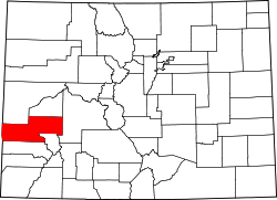
Cimarron is an unincorporated rural hamlet in Montrose County, Colorado, United States. It is located on the northern side of U.S. Highway 50, 19 miles from the town of Montrose to its west, and 42 miles from Gunnison, Colorado to its east. There is a store with fuel pumps and a post office at Cimarron. The post office services the rural ZIP Code 81220 area. [2]

Contents

Cimarron is located along the Cimarron River, just south of the Black Canyon of the Gunnison, and just outside Curecanti National Recreation Area. The D & RG Narrow Gauge Trestle crosses the Cimarron River gorge just northeast of town, and is on the National Register of Historic Places (#76000172).

Round-up in a ranch just south of the town, 1898. Colorado. Round up on the Cimarron.jpg
Round-up in a ranch just south of the town, 1898.

Climate

Cimarron has a humid continental climate (Köppen Dfb), bordering on a cold semi-arid climate (Köppen BSk).

Climate data for Cimarron, Colorado, 1991–2020 normals, 1951-2020 records: 6890ft (2100m)
MonthJanFebMarAprMayJunJulAugSepOctNovDecYear
Record high °F (°C)60
(16)
65
(18)
81
(27)
85
(29)
91
(33)
96
(36)
98
(37)
94
(34)
94
(34)
86
(30)
78
(26)
61
(16)
98
(37)
Mean maximum °F (°C)47.6
(8.7)
51.8
(11.0)
65.0
(18.3)
73.1
(22.8)
81.7
(27.6)
88.9
(31.6)
92.3
(33.5)
89.8
(32.1)
86.1
(30.1)
77.5
(25.3)
64.7
(18.2)
50.7
(10.4)
92.7
(33.7)
Mean daily maximum °F (°C)34.8
(1.6)
39.6
(4.2)
51.0
(10.6)
60.0
(15.6)
70.2
(21.2)
80.9
(27.2)
85.5
(29.7)
83.0
(28.3)
76.3
(24.6)
64.3
(17.9)
48.7
(9.3)
35.9
(2.2)
60.9
(16.0)
Daily mean °F (°C)18.8
(−7.3)
24.7
(−4.1)
34.8
(1.6)
43.0
(6.1)
51.1
(10.6)
59.2
(15.1)
65.4
(18.6)
63.8
(17.7)
56.4
(13.6)
45.0
(7.2)
32.5
(0.3)
21.0
(−6.1)
43.0
(6.1)
Mean daily minimum °F (°C)2.7
(−16.3)
9.8
(−12.3)
18.6
(−7.4)
26.1
(−3.3)
32.0
(0.0)
37.5
(3.1)
45.3
(7.4)
44.6
(7.0)
36.5
(2.5)
25.7
(−3.5)
16.4
(−8.7)
6.0
(−14.4)
25.1
(−3.8)
Mean minimum °F (°C)−18.4
(−28.0)
−15.1
(−26.2)
−1.4
(−18.6)
12.0
(−11.1)
20.1
(−6.6)
27.5
(−2.5)
34.6
(1.4)
34.3
(1.3)
23.2
(−4.9)
10.6
(−11.9)
−4.8
(−20.4)
−17.6
(−27.6)
−23.9
(−31.1)
Record low °F (°C)−43
(−42)
−40
(−40)
−26
(−32)
−9
(−23)
4
(−16)
19
(−7)
29
(−2)
27
(−3)
13
(−11)
−8
(−22)
−24
(−31)
−33
(−36)
−43
(−42)
Average precipitation inches (mm)1.09
(28)
0.94
(24)
0.91
(23)
1.22
(31)
1.28
(33)
0.68
(17)
1.37
(35)
1.41
(36)
1.82
(46)
1.35
(34)
1.04
(26)
1.17
(30)
14.28
(363)
Average snowfall inches (cm)14.50
(36.8)
11.60
(29.5)
8.20
(20.8)
5.70
(14.5)
1.10
(2.8)
0.00
(0.00)
0.00
(0.00)
0.00
(0.00)
0.00
(0.00)
1.40
(3.6)
9.70
(24.6)
14.50
(36.8)
66.7
(169.4)
Source 1: NOAA [3]
Source 2: XMACIS2 (records & monthly max/mins) [4]

Montrose 11 ENE is a weather station near Cimarron. [5] Montrose 11 ENE also has a humid continental climate (Köppen Dfb), but with a lower diurnal variation and a higher level of precipitation.

Climate data for Montrose 11 ENE, Colorado, 1991–2020 normals, 2004-2020 snowfall: 8402ft (2561m)
MonthJanFebMarAprMayJunJulAugSepOctNovDecYear
Record high °F (°C)50
(10)
55
(13)
68
(20)
73
(23)
79
(26)
88
(31)
89
(32)
87
(31)
85
(29)
76
(24)
64
(18)
52
(11)
89
(32)
Mean maximum °F (°C)43.6
(6.4)
46.1
(7.8)
56.5
(13.6)
66.5
(19.2)
73.9
(23.3)
82.4
(28.0)
85.1
(29.5)
83.0
(28.3)
79.0
(26.1)
69.4
(20.8)
59.8
(15.4)
46.5
(8.1)
85.6
(29.8)
Mean daily maximum °F (°C)31.1
(−0.5)
34.1
(1.2)
41.9
(5.5)
50.4
(10.2)
61.4
(16.3)
72.2
(22.3)
77.7
(25.4)
75.2
(24.0)
67.2
(19.6)
55.0
(12.8)
41.5
(5.3)
31.0
(−0.6)
53.2
(11.8)
Daily mean °F (°C)22.6
(−5.2)
25.6
(−3.6)
32.5
(0.3)
39.7
(4.3)
49.6
(9.8)
59.7
(15.4)
65.3
(18.5)
63.1
(17.3)
55.4
(13.0)
43.9
(6.6)
32.4
(0.2)
22.8
(−5.1)
42.7
(6.0)
Mean daily minimum °F (°C)14.2
(−9.9)
17.1
(−8.3)
23.1
(−4.9)
29.0
(−1.7)
37.9
(3.3)
47.2
(8.4)
53.0
(11.7)
51.0
(10.6)
43.7
(6.5)
32.9
(0.5)
23.3
(−4.8)
14.6
(−9.7)
32.3
(0.1)
Mean minimum °F (°C)−1.3
(−18.5)
0.6
(−17.4)
7.1
(−13.8)
13.9
(−10.1)
25.5
(−3.6)
35.3
(1.8)
45.8
(7.7)
44.2
(6.8)
31.9
(−0.1)
16.2
(−8.8)
5.5
(−14.7)
−2.5
(−19.2)
−6.8
(−21.6)
Record low °F (°C)−12
(−24)
−18
(−28)
−1
(−18)
6
(−14)
18
(−8)
30
(−1)
39
(4)
39
(4)
22
(−6)
−4
(−20)
−7
(−22)
−10
(−23)
−18
(−28)
Average precipitation inches (mm)1.67
(42)
1.70
(43)
2.18
(55)
2.58
(66)
1.81
(46)
0.63
(16)
1.19
(30)
1.83
(46)
2.11
(54)
1.92
(49)
1.81
(46)
1.73
(44)
21.16
(537)
Average snowfall inches (cm)18.2
(46)
21.4
(54)
17.6
(45)
11.7
(30)
4.8
(12)
0.1
(0.25)
0.0
(0.0)
0.0
(0.0)
0.6
(1.5)
4.7
(12)
13.0
(33)
24.2
(61)
116.3
(294.75)
Source 1: NOAA [6]
Source 2: XMACIS2 (Black Canyon snowfall, records & monthly max/mins) [4]

See also

Related Research Articles

<span class="mw-page-title-main">Salida, Colorado</span> City in Colorado, United States

Salida is the statutory city that is the county seat and the most populous municipality of Chaffee County, Colorado, United States. The population was 5,666 at the 2020 census.

<span class="mw-page-title-main">Montrose, Colorado</span> City in Colorado, United States

Montrose is a home rule municipality that is the county seat and the most populous municipality of Montrose County, Colorado, United States. The city population was 20,291 at the 2020 census, within a total area of 18.5 square miles. The main road that leads in and out of Montrose is U.S. Highway 50. The city is located in western Colorado, in the Uncompahgre Valley, and is an economic, labor, and transportation waypoint for the surrounding recreation industry. Montrose is the second-largest city in western Colorado, after Grand Junction.

<span class="mw-page-title-main">Yampa, Colorado</span> Town in Routt County, Colorado, United States

Yampa is a statutory town in Routt County, Colorado, United States. The population was 399 at the 2020 census.

<span class="mw-page-title-main">Bergland Township, Michigan</span> Civil township in Michigan, United States

Bergland Township is a civil township of Ontonagon County in the U.S. state of Michigan. As of the 2020 census, the township population was 438.

<span class="mw-page-title-main">McClure Pass</span>

McClure Pass is a mountain pass in the Rocky Mountains of western Colorado in the United States. It is located along the boundary between Pitkin and Gunnison counties, in a gap at the western side of the Elk Mountains. The pass is at an elevation of 8,755 feet (2,669 m)) and separates the headwaters of the Crystal River to the east with the headwaters of the North Fork Gunnison River to the west. The pass is named in honor of Thomas "Mack" McClure who in the late 19th Century owned a large house at the eastern base of the pass. The house served as a stage stop where McClure fed and lodged travelers.

<span class="mw-page-title-main">Grant, Colorado</span> Unincorporated community in Park County, Colorado, United States

Grant is an unincorporated community and a U.S. Post Office in Park County, Colorado, United States.

Keene is an unincorporated community in McKenzie County, North Dakota in the United States. In this zip code area, the 2000 census found 258 people.

<span class="mw-page-title-main">Blue Mesa Reservoir</span> Lake on the Gunnison River in Colorado, United States

Blue Mesa Reservoir is an artificial reservoir located on the upper reaches of the Gunnison River in Gunnison County, Colorado. The largest lake located entirely within the state, Blue Mesa Reservoir was created by the construction of Blue Mesa Dam, a 390 feet (120 m) tall earthen fill dam constructed on the Gunnison by the U.S. Bureau of Reclamation in 1966 for the generation of hydroelectric power. Managed as part of the Curecanti National Recreation Area, a unit of the National Park Service, Blue Mesa Reservoir is the largest lake trout and Kokanee salmon fishery in Colorado.

<span class="mw-page-title-main">Chromo, Colorado</span> Unincorporated community in State of Colorado, United States

Chromo is an unincorporated community and U.S. Post Office in Archuleta County, Colorado, United States. The Chromo Post Office has the ZIP Code 81128.

<span class="mw-page-title-main">Coalmont, Colorado</span> Unincorporated community in Jackson County, Colorado, United States

Coalmont is an unincorporated community and U.S. Post Office in Jackson County, Colorado, United States. The town is named for the open-pit lignite coal mines in the area, from which coal was shipped out on the Union Pacific Railroad to the mainline at Laramie, Wyoming.

Hamilton is an unincorporated community with a U.S. Post Office in Moffat County, Colorado, United States. The Hamilton Post Office has the ZIP Code 81638.

<span class="mw-page-title-main">Maybell, Colorado</span> Census-designated place in Moffat County, Colorado, United States

Maybell is an unincorporated community and census-designated place (CDP) in and governed by Moffat County, Colorado, United States. The CDP is a part of the Craig, CO Micropolitan Statistical Area.

<span class="mw-page-title-main">Sargents, Colorado</span> Unincorporated community in Saguache County, Colorado, United States

Sargents is an unincorporated community and a U.S. Post Office in Saguache County, Colorado, United States. The Sargents Post Office has the ZIP code 81248.

<span class="mw-page-title-main">Sapinero, Colorado</span> Unincorporated community in Gunnison County, Colorado, United States

Sapinero is an unincorporated community located on U.S. Route 50, along the shore of Blue Mesa Reservoir in the Curecanti National Recreation Area in Gunnison County, Colorado, United States.

<span class="mw-page-title-main">Bear Lake (Colorado)</span>

Bear Lake is a scenic trailhead and destination in Rocky Mountain National Park. Sitting at an elevation of 9,450 feet (2,880 m), the alpine lake rests beneath the sheer flanks of Hallett Peak and the Continental Divide at 40.31324°N 105.648222°W. Several trails, from easy strolls to strenuous hikes, start from the lake. The Bear Lake Road is open year-round, though it may temporarily close due to adverse weather conditions. An ample parking lot is provided close to the lake. The Bear Lake Road is approximately 10 miles (16 km) long and starts close to the Beaver Meadows Entrance station of the Rocky Mountain National Park.

<span class="mw-page-title-main">Elk City, Idaho</span> Census-designated place in Idaho, United States

Elk City is a census-designated place in Idaho County, Idaho, United States. As of the 2020 census, its population was 170.

<span class="mw-page-title-main">Upper Bear Creek, Colorado</span> Census Designated Place in Colorado, United States

Upper Bear Creek is an unincorporated community and a census-designated place (CDP) located in and governed by Clear Creek County, Colorado, United States. The CDP is a part of the Denver–Aurora–Lakewood, CO Metropolitan Statistical Area. The population of the Upper Bear Creek CDP was 984 at the United States Census 2020. The Evergreen post office serves the area.

<span class="mw-page-title-main">Lemon Dam</span> Dam in La Plata County, Colorado

The earthen dam is a project of the United States Bureau of Reclamation and was completed in 1963, at 284 feet (87 m) high and 1,360 feet (410 m) long at its crest. The dam impounds the Florida River for flood control and irrigation water storage, operated by the local Florida Water Conservancy District. 120 kW of hydroelectric power is generated here.

<span class="mw-page-title-main">Sula, Montana</span> Census-designated place in Montana, United States

Sula is a census-designated place (CDP) in Ravalli County, Montana, United States. It is named after the community of Sula, which it encompasses, and was established about 2010, prior to that year's census. The population of the CDP was 37 at the 2010 census.

Muddy Mountain is a peak in the Laramie Mountains approximately 12 miles (19 km) south-south-east of Casper, Wyoming. There is a two-mile (3.2 km) "interpretive nature trail" maintained by the Bureau of Land Management, as well as a series of trails popular with mountain bikers, horseback riders, and ATVs in the summer, and snowmobiles in the winter.

References

  1. 1 2 U.S. Geological Survey Geographic Names Information System: Cimarron, Colorado
  2. 1 2 "ZIP Code Lookup". United States Postal Service. December 15, 2006. Archived from the original (JavaScript/HTML) on September 3, 2007. Retrieved December 15, 2006.
  3. "Cimarron, Colorado 1991-2020 Monthly Normals" . Retrieved January 1, 2024.
  4. 1 2 "xmACIS". National Oceanic and Atmospheric Administration. Retrieved January 1, 2024.
  5. "Station Details - MONTROSE 11 ENE, CO US". NOAA. Retrieved January 1, 2024.
  6. "Montrose 11 ENE, Colorado 1991-2020 Monthly Normals" . Retrieved January 1, 2024.