City Creek (California)

Last updated
City Creek
River
City Creek, Highland CA.jpg
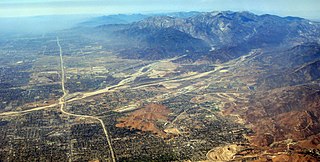
The nearly-dry bed of City Creek near Highland, California
Country United States
State California
Region San Bernardino County
Part of Santa Ana River
Tributaries
 - leftEast Fork City Creek
 - rightWest Fork City Creek
City Highland
SourceConfluence of East and West Forks
 - elevation2,280 ft (695 m)
 - coordinates 34°17′33″N117°18′22″W / 34.29250°N 117.30611°W / 34.29250; -117.30611   [1]
Mouth Santa Ana River
 - locationEast of San Bernardino International Airport
 - elevation1,037 ft (316 m) [1]
 - coordinates 34°09′55″N117°21′43″W / 34.16528°N 117.36194°W / 34.16528; -117.36194 Coordinates: 34°09′55″N117°21′43″W / 34.16528°N 117.36194°W / 34.16528; -117.36194   [1]
Length7.5 mi (12 km), North-south
Basin19.6 sq mi (51 km2) [2]
Discharge
 - average10.1 cu ft/s (0 m3/s) [2]
 - max7,000 cu ft/s (198 m3/s)
 - min2.6 cu ft/s (0 m3/s)
Relief map of California.png
Red pog.svg
Location of the mouth in California

City Creek is a 7.5-mile (12.1 km) tributary of the Santa Ana River in western San Bernardino County in the U.S. state of California. Its watershed drains about 19.6 square miles (51 km2) on the southwest slopes of the San Bernardino Mountains. Although short, the creek stretches about 12 miles (19 km) to its farthest source.

Santa Ana River river in California, United States

The Santa Ana River is the largest river entirely within Southern California in the United States. It rises in the San Bernardino Mountains and flows for most of its length through San Bernardino and Riverside Counties, before cutting through the northern Santa Ana Mountains via Santa Ana Canyon and flowing southwest through urban Orange County to drain into the Pacific Ocean. The Santa Ana River is 96 miles (154 km) long, and its drainage basin is 2,650 square miles (6,900 km2) in size.

San Bernardino County, California County in California, United States

San Bernardino County, officially the County of San Bernardino, is a county located in the southern portion of the U.S. state of California, and is located within the Greater Los Angeles area. As of the 2010 U.S. Census, the population was 2,035,210, making it the fifth-most populous county in California, and the 12th-most populous in the United States. The county seat is San Bernardino.

U.S. state constituent political entity of the United States

In the United States, a state is a constituent political entity, of which there are currently 50. Bound together in a political union, each state holds governmental jurisdiction over a separate and defined geographic territory and shares its sovereignty with the federal government. Due to this shared sovereignty, Americans are citizens both of the federal republic and of the state in which they reside. State citizenship and residency are flexible, and no government approval is required to move between states, except for persons restricted by certain types of court orders. Four states use the term commonwealth rather than state in their full official names.

It rises in two forks of similar length and size, West Fork City Creek and East Fork City Creek, in the San Bernardino National Forest. Both forks begin on the crest of the San Bernardino Mountains. The West Fork rises near Crest Summit south of the unincorporated community of Crest Park, at about 5,400 feet (1,600 m). It flows south then southeast and finally south again through multiple gorges, picking up several unnamed tributaries. The East Fork begins in a fan-shaped group of gulches south of Heaps Peak and Mount Sorenson, at about 6,000 feet (1,800 m). From there it runs south-southwest in a canyon past Fredalba, receiving Schenk Creek from the left near the mouth. The West Fork is about 4 miles (6.4 km) long; the East Fork stretches roughly 3 miles (4.8 km).

San Bernardino National Forest

The San Bernardino National Forest is a United States National Forest in Southern California encompassing 823,816 acres (3,333.87 km2) of which 677,982 acres (2,743.70 km2) are federal. The forest is made up of two main divisions, the eastern portion of the San Gabriel Mountains and the San Bernardino Mountains on the easternmost of the Transverse Ranges, and the San Jacinto and Santa Rosa Mountains on the northernmost of the Peninsular Ranges. Elevations range from 2,000 to 11,499 feet. The forest includes seven wilderness areas: San Gorgonio, Cucamonga, San Jacinto, South Fork San Jacinto, Santa Rosa, Cahuilla Mountain and Bighorn Mountain. Forest headquarters are located in the city of San Bernardino. There are district offices in Lytle Creek, Idyllwild, and Fawnskin.

Crest Park, California Unincorporated community in California, United States

Crest Park is an unincorporated community in San Bernardino County, California, United States. Crest Park is located in the San Bernardino Mountains on California State Route 18 1 mile (1.6 km) south of Lake Arrowhead. Crest Park had a post office with ZIP code 92326, which opened in 1949.

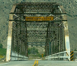
The two forks combine in a steep chasm just downstream of where the West Fork passes under a bridge of California State Route 330, also known as City Creek road. The main stem flows south in a thousand-foot-deep gorge between McKinley and Harrison Mountains, rapidly dropping to the plains near Highland, where most of its flow is diverted into canals for municipal and agricultural usage. Downstream of the diversions the creek fans out into alluvial deposits. Cook, Bledsoe and Elder Gulches as well as Plunge Creek all enter from the left as the creek flows along the east side of Highland in a wide flood control channel. It joins the Santa Ana River to the southeast of San Bernardino International Airport.

California State Route 330 highway in California

State Route 330 is a state highway in the U.S. state of California. It is also known as City Creek Road in the San Bernardino Mountains.

Highland, California City in California, United States

Highland is a city in San Bernardino County, California, United States. The population in 2010 was 53,104, up from 44,605 at the 2000 census. The term Highland also refers to a geographical area of the city of San Bernardino, and parts of unincorporated San Bernardino County. Highland is generally divided into two regions, East Highland and Highland

Flood control channel engineered canal designed to manage floodwater

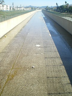
Flood control channels are large and empty basins which let water flow in and out or dry channels that run below the street levels of some larger cities, so that if and when a flood occurs, the water will run into these channels, and eventually drain into a river or other body of water. Flood channels are sometimes built on the former courses of waterways as a way to reduce flooding.

See also

Related Research Articles

Feather River river in the United States of America

The Feather River is the principal tributary of the Sacramento River, in the Sacramento Valley of Northern California. The river's main stem is about 73 miles (117 km) long. Its length to its most distant headwater tributary is just over 210 miles (340 km). The main stem Feather River begins in Lake Oroville, where its four long tributary forks join together—the South Fork, Middle Fork, North Fork, and West Branch Feather Rivers. These and other tributaries drain part of the northern Sierra Nevada, and the extreme southern Cascades, as well as a small portion of the Sacramento Valley. The total drainage basin is about 6,200 square miles (16,000 km2), with approximately 3,604 square miles (9,330 km2) above Lake Oroville.

Whitewater River (California) stream in California

The Whitewater River is a small permanent stream in western Riverside County, California, with a small upstream section in southwestern San Bernardino County. Its headwaters are in the San Bernardino Mountains and mouth—terminus in the Colorado Desert. The Whitewater River is in the endorheic Salton Sea drainage basin.

San Jacinto River (California)

The San Jacinto River is a 42-mile-long (68 km) river in Riverside County, California. The river's headwaters are in San Bernardino National Forest, but the lower portion of the 765-square-mile (1,980 km2) watershed is urban and agricultural land. As a partially endorheic watershed that is contiguous with other Great Basin watersheds, the western side of the San Jacinto Basin is a portion of the Great Basin Divide.

Lytle Creek (California) river in the United States of America

Lytle Creek, California, is an approximately 18-mile-long (29 km) stream in southwestern San Bernardino County near the city of San Bernardino. It is a tributary of Warm Creek, a tributary of the Santa Ana River. The Mormon settlers of San Bernardino named the stream "Lytle Creek" after their leader, Captain Andrew Lytle.

Chowchilla River river in the United States of America

The Chowchilla River is a river in central California, United States and a minor tributary of the San Joaquin River. It flows for 54.2 miles (87.2 km) from the western side of the Sierra Nevada Range to the San Joaquin River system in the San Joaquin Valley.

Piru Creek river in the United States of America

Piru Creek is a major stream, about 71 miles (114 km) long, in northern Los Angeles County and eastern Ventura County, California. It is a tributary of the Santa Clara River, the largest stream system in Southern California that is still relatively natural.

Salmon River (Clackamas County, Oregon) river in Oregons Cascade Range

The Salmon River is a 33.5-mile (53.9 km) river in the Cascade Range in the U.S. state of Oregon that drains part of southwestern Mount Hood. The entire length of the river is a protected National Wild and Scenic River. Several portions are in protected wilderness. It is affluent to the Sandy River, a tributary of the Columbia River.

South Fork Kern River river in the United States of America

The South Fork Kern River is a tributary of the Kern River in the Sierra Nevada of the U.S. state of California. It is one of the southernmost rivers on the western slope of the mountains, and drains a high, relatively dry plateau country of 982 square miles (2,540 km2) along the Sierra Crest. The upper South Fork flows through a series of rugged canyons, but it also drains a flat, marshy valley before joining the Kern River at Lake Isabella.

Coyote Creek (San Gabriel River tributary) stream in Southern California, tributary of the San Gabriel River

Coyote Creek is a principal tributary of the San Gabriel River in northwest Orange County, southeast Los Angeles County, and southwest Riverside County, California. It drains a land area of roughly 41.3 square miles (107 km2) covering five major cities, including Brea, Buena Park, Fullerton, La Habra, and La Palma. Some major tributaries of the creek in the highly urbanized watershed include Brea Creek, Fullerton Creek, and Carbon Creek. The mostly flat creek basin is separated by a series of low mountains, and is bounded by several small mountain ranges, including the Chino Hills, Puente Hills and West Coyote Hills.

South Fork Eel River river in the United States of America

The South Fork Eel River is the largest tributary of the Eel River in north-central California in the United States. The river flows 105 miles (169 km) north from Laytonville to Dyerville/Founders' Grove where it joins the Eel River. The South Fork drains a long and narrow portion of the Coast Range of California in parts of Mendocino and Humboldt counties. U.S. Route 101 follows the river for much of its length.

The Klamath River is a river in southern Oregon and northern California in the United States. This article describes its course.

Bear Creek (Santa Ana River tributary) tributary of the Santa Ana River in the San Bernardino Mountains of the U.S. state of California

Bear Creek is an approximately 17-mile (27 km) tributary of the Santa Ana River in the San Bernardino Mountains of the U.S. state of California.

Jemez River river in the United States of America

The Jemez River is a tributary of the Rio Grande in the U.S. state of New Mexico. The river is formed by the confluence of the East Fork Jemez River and San Antonio Creek, which drain a number of tributaries in the area of the Jemez Mountains and Santa Fe National Forest. The Jemez River is about 50 miles (80 km) long, or about 80 miles (130 km) long if its longest headwater tributary, San Antonio Creek, is included. The East Fork Jemez River is about 22 miles (35 km) long. Both San Antonio Creek and the East Fork Jemez River flow through intricate meanders along their courses. The East Fork Jemez is a National Wild and Scenic River.

North Fork American River river in the United States of America

The North Fork American River is the longest branch of the American River in Northern California. It is 88 miles (142 km) long from its source at the crest of the Sierra Nevada, near Lake Tahoe, to its mouth at Folsom Lake northeast of Sacramento. Prior to the construction of Folsom Dam the river was about 9 miles (14 km) longer making for a total length of 97 miles (156 km).

Chino Creek river in the United States of America

Chino Creek is a major stream of the Pomona Valley, in the western Inland Empire region of Southern California. It is a tributary of the Santa Ana River.

Arroyo Seco (Salinas River tributary)

The Arroyo Seco is a major tributary of the Salinas River in central California. About 40 miles (64 km) long, it drains a rugged area of the Coast Ranges east of Big Sur before flowing through the agricultural Salinas Valley.

Course of the Colorado River

The Colorado River is a major river of the western United States and northwest Mexico in North America. Its headwaters are in the Rocky Mountains where La Poudre Pass Lake is its source. Located in north central Colorado it flows southwest through the Colorado Plateau country of western Colorado, southeastern Utah and northwestern Arizona where it flows through the Grand Canyon. It turns south near Las Vegas, Nevada, forming the Arizona–Nevada border in Lake Mead and the Arizona–California border a few miles below Davis Dam between Laughlin, Nevada and Needles, California California before entering Mexico in the Colorado Desert. Most of its waters are diverted into the Imperial Valley of Southern California. In Mexico its course forms the boundary between Sonora and Baja California before entering the Gulf of California. This article describes most of the major features along the river.

Deep Creek (Mojave River tributary)

Deep Creek is a tributary of the Mojave River, 23.4 miles (37.7 km) long, in San Bernardino County, California.

East Fork San Gabriel River

The East Fork is the largest headwater of the San Gabriel River in Los Angeles County, California. It originates at the crest of the San Gabriel Mountains in the Angeles National Forest, at the confluence of the Prairie Fork and Vincent Gulch near Mount Baden-Powell. It then flows south and west for 17 miles (27 km) to San Gabriel Reservoir, where it joins with the West Fork San Gabriel River. Although the East Fork is colloquially considered a separate river, the U.S. Geological Survey officially lists the East Fork as the upper part of the main stem San Gabriel River, a fact is shown by topographical maps of the area.

References

  1. 1 2 3 "City Creek". Geographic Names Information System . United States Geological Survey. 1981-01-19. Retrieved 2010-06-22.
  2. 1 2 "11055800 City Creek near Highland, CA". 1999 California Hydrologic Date Report. U.S. Geological Survey. 1999. Retrieved 2010-06-22.