City walls of Paris

Last updated

The city limits of Paris, from the 4th century to present
.mw-parser-output .legend{page-break-inside:avoid;break-inside:avoid-column}.mw-parser-output .legend-color{display:inline-block;min-width:1.25em;height:1.25em;line-height:1.25;margin:1px 0;text-align:center;border:1px solid black;background-color:transparent;color:black}.mw-parser-output .legend-text{}
Gallo-Roman wall
First medieval wall
Wall of Philip II Augustus
Wall of Charles V
Wall of Louis XIII
Wall of the Ferme generale
Thiers wall
Today The city limits of Paris from the 4th century to 2015.svg
The city limits of Paris, from the 4th century to present
  Gallo-Roman wall
  First medieval wall
  Wall of Louis XIII
  Today

The city walls of Paris (French: enceintes de Paris or murs de Paris) refers to the city walls that surrounded Paris, France, as it grew from ancient times until the 20th century, built primarily to defend the city but also for administrative reasons. Several successive city walls were built over the centuries, either adding to existing walls or replacing demolished ones, through 1846, when construction of the Thiers wall was completed.

Contents

Overview

The city walls of Paris include:

As Paris rapidly expanded to become one of the largest cities in Europe, new walls were built to consolidate the existing city with new houses, gardens, and vegetable fields. Many historical walls were eventually destroyed (as in 1670, when Louis XIV ordered the demolition of the Louis XIII Wall), and the paths formerly occupied by the walls were often repurposed into streets or boulevards. Only a few sections of the Wall of the Farmers-General (pavilions of Claude Nicolas Ledoux) and the Wall of Philippe Auguste survive to the present day. The walls' influence on modern Paris can still be seen on some of its major streets and boulevards, such as:

Gaulish enclosure

Prior to the Roman occupation of Gaul, the settlement that eventually became the city of Paris was known to the Romans as Lutetia and inhabited by the Parisii tribe. The town lacked proper defenses and was therefore partially demolished at the beginning of the Roman occupation. The first wall of Paris was probably built by the Gauls on the River Seine, although its exact location is unknown. In his Commentaries on the Gallic War , Julius Caesar wrote: "Id est oppidum Parisiorum, quod positum est in insula fluminis Sequanae" ("This is a town of the Parisii, situated on an island on the river of the Seine"), indicating that Lutetia was a fortified camp on an island. The relationship between this island and the Île de la Cité has not been demonstrated, and excavations have not uncovered anything predating the reign of Augustus, the first Roman Emperor.[ citation needed ] Adding to the uncertainty is the 2003 discovery of the remains of a city on a site now occupied by Nanterre.

Gallo-Roman wall

Lutetia developed on the left bank of the Seine during Roman times, and to a lesser extent on the Île de la Cité. The right bank was largely uninhabitable due to marshes. During the first barbarian invasions in AD 285, the people of Lutetia abandoned the left bank, taking refuge on the Île de la Cité and destroying the bridges. The eastern half of the island was protected by a wall, constructed of rocks collected from the Arènes de Lutèce.

First medieval wall

Traces of an enclosure at the corner of the rue de l'Arbre-Sec and the rue de Rivoli were discovered in 2009 during excavations made by Institut national de recherches archéologiques préventives  [ fr ] (INRAP), the French National Institute for Preventive Archaeological Research. [1] This confirmed the probable existence of an enclosure around the centre of Paris on the right bank around the 10th century. This wall was most likely built as a result of a Viking siege in 885 and was constructed by either Odo of France or Robert I of France. The fortification wall consisted of a ditch 3-metre (9.8 ft) deep and 12-metre (39 ft) wide coupled with a raised bank likely topped by a timber pallisade.

Wall of Philip Augustus

The Wall of Philippe Auguste FranceEnglandCard2 052.jpg
The Wall of Philippe Auguste

Paris grew very quickly during the early Middle Ages and soon extended from the Montagne Sainte-Geneviève to the roads leading to the abbey of Saint-Denis. A new wall was begun in 1190 on the order and funding of King Philip II of France (also known as Philip Augustus) and was completed by 1213, [2] enclosing 253 hectares on both sides of the Seine. This new wall was 8 feet (2.4 m) thick in some places, protected by wide and deep ditches, and was fortified with as many as five hundred towers.

The Wall of Philippe Auguste ran from the current location of the Pont des Arts, approached the porte Saint-Honoré, opened at the porte Coquillière, reached the porte Saint-Denis, porte Mauconseil, porte Babette, came to rue Vielle-du-Temple, the rue des Francs-Bourgeois, to the porte Baudoyer and the quai des Célestins. On the south side, the wall picked up at the Palais de la Tournelle, opened at the porte Saint-Victor, porte Bordet, porte Saint-Jacques, Porte Saint-Michel, porte des Corderliers, near the cour de la Commerce, the porte de Buci, and ended at the Tour de Nesle. Many elements of the wall's structure were later incorporated into private buildings or into the subsequent Wall of Charles V.

Wall of Charles V

The Wall of Charles V was built from 1356 to 1383, during the reign of Charles V and his son and successor Charles VI. The area enclosed on the left bank remained the same as with the Wall of Philippe Auguste, but the area enclosed on the right bank increased to include the mansions of the Marais and the Templar enclosure. The new city limits totaled 439 hectares across the two banks. During the construction of the Wall of Louis XIII, the Wall of Charles V was partly incorporated into the new wall and partly destroyed.

Louis XIII Wall

Map of Paris in 1705 with the first boulevards and the remaining part of the Louis XIII Wall Plan de Paris 1705 BNF07710700.png
Map of Paris in 1705 with the first boulevards and the remaining part of the Louis XIII Wall

The Louis XIII Wall, also known as the "yellow ditches wall", was designed by Jacques Lemercier and built between 1633 and 1636. It enlarged the Wall of Charles V over the western part of the right bank (now the First and Second Arrondissements).

From 1670 onward, Louis XIV believed that Paris had been made a secure city as a result of his conquests, and he therefore ordered the wall destroyed. Its route was later replaced with the grands boulevards.

Wall of the Farmers-General

The Wall of the Farmers-General was built in the years between 1784 and 1791 under the direction of Claude Nicolas Ledoux and at the request of the Ferme Générale. It enclosed 3,402 hectares, including the village of Austerlitz, which was incorporated into Paris in 1818. Unlike previous walls, the goal of this wall was not to defend Paris, but to collect taxes and fees on behalf of the government which caused much resentment from the public. [3] It was destroyed when the city limits were extended to the Thiers wall in 1860.

This wall was later replaced by a second belt of boulevards: Charonne, Ménilmontant, Belleville, La Villette, La Chapelle, Clichy, Batignolles, Courcelles, avenue de Wagram and Iena, streets Benjamin Franklin and Alboni, boulevard de Grenelle, Garibaldi, Pasteur, Montparnasse, Edgar Quinet, Raspail, Saint-Jacques, Auguste-Blanqui, Vincent Auriol, Bercy, and Picpus.

Thiers Wall

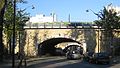
The Thiers wall was constructed from 1841 to 1846 after being proposed by prime minister and future President of France Adolphe Thiers. It enclosed 7,802 hectares along the present-day Boulevards des Maréchaux and a glacis extending to the location of today's Boulevard Périphérique. It was demolished between 1919 and 1929.

See also

Related Research Articles

<span class="mw-page-title-main">Boulevard Périphérique</span> Ring road

The Boulevard Périphérique, often called the Périph, is a controlled-access dual-carriageway ring road in Paris, France. With a few exceptions, it is situated along Paris's administrative limit.

<span class="mw-page-title-main">6th arrondissement of Paris</span> Municipal arrondissement in Île-de-France, France

The 6th arrondissement of Paris is one of the 20 arrondissements of the capital city of France. In spoken French, it is referred to as le sixième.

<span class="mw-page-title-main">Île de la Cité</span> Island in the river Seine, Paris, France

Île de la Cité is an island in the river Seine in the center of Paris. In the 4th century, it was the site of the fortress of the Roman governor. In 508, Clovis I, the first King of the Franks, established his palace on the island. In the 12th century, it became an important religious center, the home of Notre-Dame cathedral, and the royal chapel of Sainte-Chapelle, as well as the city's first hospital, the Hôtel-Dieu. It is also the site of the city's oldest surviving bridge, the Pont Neuf.

<span class="mw-page-title-main">History of Paris</span>

The oldest traces of human occupation in Paris are human bones and evidence of an encampment of hunter-gatherers dating from about 8000 BC, during the Mesolithic period. Between 250 and 225 BC, the Parisii, a sub-tribe of the Celtic Senones, settled on the banks of the Seine, built bridges and a fort, minted coins, and began to trade with other river settlements in Europe.

<span class="mw-page-title-main">Lutetia</span> Roman city, predecessor of Paris

Lutetia, also known as Lutecia and Lutetia Parisiorum, was a Gallo–Roman town and the predecessor of modern-day Paris. Traces of an earlier Neolithic settlement have been found nearby, and a larger settlement was established around the middle of the third century BC by the Parisii, a Gallic tribe. The site was an important crossing point of the Seine, the intersection of land and water trade routes.

<span class="mw-page-title-main">Musée Carnavalet</span> History Museum, Art museum, Historic site in Paris, France

The Musée Carnavalet in Paris is dedicated to the history of the city. The museum occupies two neighboring mansions: the Hôtel Carnavalet and the former Hôtel Le Peletier de Saint Fargeau. On the advice of Baron Haussmann, the civil servant who transformed Paris in the latter half of the 19th century, the Hôtel Carnavalet was purchased by the Municipal Council of Paris in 1866; it was opened to the public in 1880. By the latter part of the 20th century, the museum was full to capacity. The Hôtel Le Peletier de Saint Fargeau was annexed to the Carnavalet and opened to the public in 1989.

<span class="mw-page-title-main">Timeline of Paris</span>

The following is a timeline of the history of the city of Paris, France.

Wall of the <i>Ferme générale</i> 18th-century city wall of Paris

The Wall of the Ferme générale was one of the several city walls of Paris built between the early Middle Ages and the mid 19th century. Built between 1784 and 1791, the 24 km wall crossed the districts of the Place de l'Étoile, Batignolles, Pigalle, Belleville, Nation, the Place d'Italie, Denfert-Rochereau, Montparnasse and the Trocadéro, roughly following the route now traced by line 2 and line 6 of the Paris Métro. The wall was demolished in the early 1860s, although elements of some of its gates remain.

<span class="mw-page-title-main">Boulevards of Paris</span> Thoroughfare in Paris, France

The Boulevards of Paris are boulevards which form an important part of the urban landscape of Paris. The boulevards were constructed in several phases by central government initiative as infrastructure improvements, but are very much associated with strolling and leisurely enjoyment in the minds of Parisians.

<span class="mw-page-title-main">Boulevards of the Marshals</span> Thoroughfare in Paris, France

The Boulevards of the Marshals are a collection of thoroughfares that encircle the city of Paris, France, just inside its city limits. Most bear the name of a marshal of the First French Empire (1804–1814) who served under Napoleon I. The Île-de-France tramway Lines 3a and 3b today run on the Boulevards of the Marshals.

<span class="mw-page-title-main">City gates of Paris</span>

While Paris is encircled by the Boulevard Périphérique, the city gates of Paris are the access points to the city for pedestrians and other road users. As Paris has had successive ring roads through the centuries, city gates are found inside the modern-day Paris.

<span class="mw-page-title-main">Wall of Philip II Augustus</span> Oldest city wall of Paris, France

The Wall of Philip Augustus is the oldest city wall of Paris (France) whose plan is accurately known. Partially integrated into buildings, more traces of it remain than of the later fortifications.

<span class="mw-page-title-main">Wall of Charles V</span> City wall of Paris built by Charles V of France

The wall of Charles V, built from 1356 to 1383 is one of the city walls of Paris built on orders granted by Charles V of France. It was built on the right bank of the river Seine outside the wall of Philippe Auguste. In the 1640s, the western part of the wall of Charles V was demolished and replaced by the larger Louis XIII wall, with the demolished material reused for the new wall. This new enclosure (enceinte) was completely destroyed in the 1670s and was replaced by the Grands Boulevards.

<span class="mw-page-title-main">Thiers wall</span> Former defensive wall in Paris

The Thiers wall was the last of the defensive walls of Paris. It was an enclosure constructed between 1841 and 1846 and was proposed by the French prime minister Adolphe Thiers but was actually implemented by his successor. The 33 kilometres (21 mi) long wall and ditch made a complete circuit around the city as it stood at the time of the July Monarchy. It was bombarded by the Prussian Army during the Franco-Prussian War, captured by government troops during the Paris Commune and refortified at the start of the First World War. However, by then it had become obsolete as a fortification and was a barrier to the expansion of the city. The area immediately outside of it, known as "the zone", had become a shanty town. The wall was demolished in the interwar period; its path today can be traced by the Boulevards of the Marshals which originally ran just behind the fortifications and by the Boulevard Périphérique which was later built just outside. A few remnants of the wall can still be seen.

<span class="mw-page-title-main">Fortifications of Paris in the 19th and 20th centuries</span> List of forts in and around Paris, France

The fortifications of Paris in the 19th and 20th centuries comprise:

<span class="mw-page-title-main">Porte Saint-Antoine</span>

The Porte Saint-Antoine was one of the gates of Paris. There were two gates named the Porte Saint-Antoine, both now demolished, of which the best known was that guarded by the Bastille, on the site now occupied by the start of Rue de la Bastille in the 4th arrondissement of Paris.

This article presents the main landmarks in the city of Paris within administrative limits, divided by its 20 arrondissements. Landmarks located in the suburbs of Paris, outside of its administrative limits, while within the metropolitan area are not included in this article.

<span class="mw-page-title-main">Paris in the Middle Ages</span>

In the 10th century Paris was a provincial cathedral city of little political or economic significance, but under the kings of the Capetian dynasty who ruled France between 987 and 1328, it developed into an important commercial and religious center and the seat of the royal administration of the country. The Île de la Cité became the site of the royal palace and the new cathedral of Notre-Dame, begun in 1163. The Left Bank was occupied by important monasteries, including the Abbey of Saint-Germain-des-Prés and the Abbey of St Genevieve. In the late 1100s, the collection of colleges on the left bank became one of the leading universities in Europe. The Right Bank, where the ports, central markets, artisans and merchants were located, became the commercial center of the city, and the merchants assumed an important role in running the city. Paris became a center for the creation of illuminated manuscripts and the birthplace of Gothic architecture. Despite civil wars, the plague, and foreign occupation, Paris became the most populous city in the Western world during the Middle Ages.

<span class="mw-page-title-main">Outline of Paris</span> Overview of and topical guide to Paris

The following outline is provided as an overview of and topical guide to Paris:

References

  1. "Site archéologique : Sur les traces de la première enceinte médiévale de Paris | Inrap". Inrap (in French). 25 January 2011. Retrieved 17 January 2018.
  2. Jones, Colin (6 April 2006). Paris: Biography of a City. Penguin Adult. pp. 53–54. ISBN   978-0-14-028292-4.
  3. Bryson, Bill (2004). A Short History of Nearly Everything. Great Britain: Black Swan. p. 133.

Bibliography